193.174.119.243 - IP Lookup: Free IP Address Lookup, Postal Code Lookup, IP Location Lookup, IP ASN, Public IP
Country:
Region:
City:
Location:
Time Zone:
Postal Code:
IP information under different IP Channel
ip-api
Country
Region
City
ASN
Time Zone
ISP
Blacklist
Proxy
Latitude
Longitude
Postal
Route
Luminati
Country
Region
bb
City
frankfurtoder
ASN
Time Zone
Europe/Berlin
ISP
Verein zur Foerderung eines Deutschen Forschungsnetzes e.V.
Latitude
Longitude
Postal
IPinfo
Country
Region
City
ASN
Time Zone
ISP
Blacklist
Proxy
Latitude
Longitude
Postal
Route
IP2Location
193.174.119.243Country
Region
nordrhein-westfalen
City
lemgo
Time Zone
Europe/Berlin
ISP
Language
User-Agent
Latitude
Longitude
Postal
db-ip
Country
Region
City
ASN
Time Zone
ISP
Blacklist
Proxy
Latitude
Longitude
Postal
Route
ipdata
Country
Region
City
ASN
Time Zone
ISP
Blacklist
Proxy
Latitude
Longitude
Postal
Route
Popular places and events near this IP address

Lippe (district)
District in North Rhine-Westphalia, Germany
Distance: Approx. 3333 meters
Latitude and longitude: 52,8.91666667
Lippe (German pronunciation: [ˈlɪpə]) is a Kreis (district) in the east of North Rhine-Westphalia, Germany. Neighboring districts are Herford, Minden-Lübbecke, Höxter, Paderborn, Gütersloh, and district-free Bielefeld, which forms the region Ostwestfalen-Lippe. The district of Lippe is named after the Lords of Lippe, who originally lived on the river Lippe and founded Lippstadt there, and their Principality of Lippe.

Lemgo
Town in North Rhine-Westphalia, Germany
Distance: Approx. 871 meters
Latitude and longitude: 52.02722222,8.91166667
Lemgo (German pronunciation: [ˈlɛmɡoː]; Low German: Lemge, Lemje) is a University and Old Hanseatic town in the Lippe district of North Rhine-Westphalia, Germany. It is situated between the Teutoburg Forest and the Weser Uplands, 25 km east of Bielefeld and 70 km west of Hannover. Lemgo is the oldest town in the former principality of Lippe and has a population of c.

Dörentrup
Municipality in North Rhine-Westphalia, Germany
Distance: Approx. 6941 meters
Latitude and longitude: 52.03305556,9
Dörentrup is a municipality in the Lippe district of North Rhine-Westphalia, Germany. It has an area of 49.79 km2 and c. 8,000 inhabitants (2013).

Lipperlandhalle
Distance: Approx. 1368 meters
Latitude and longitude: 52.01694444,8.90805556
Lipperlandhalle is an indoor sporting arena located at the Innovation Campus Lemgo, Germany. The capacity of the arena is 5,000 people. It hosted some matches at the 2007 World Men's Handball Championship.

Lower Saxon Hills
Natural region in Germany
Distance: Approx. 7585 meters
Latitude and longitude: 52,9
The Lower Saxon Hills (German: Niedersächsisches Bergland) are one of the 73 natural regions in Germany defined by the Federal Agency for Nature Conservation (BfN). Geographically it covers roughly the same area as the Weser Uplands (German: Weserbergland) in its wider sense. The region is part of Germany's Central Uplands with hills ranging up to 528 m above sea level (NN) in height that extend across northeast North Rhine-Westphalia, southern Lower Saxony and northern Hesse.

Oettern-Bremke
Ortsteil of Detmold in North Rhine-Westphalia, Germany
Distance: Approx. 7025 meters
Latitude and longitude: 51.96722222,8.87083333
Oettern-Bremke is a village in the borough of Detmold in the district of Lippe in the German federal state of North Rhine-Westphalia and lies about 5 km north of the town centre. The neighbouring Detmold villages are, in a clockwise direction, Bentrup, Loßbruch, Klüt, Jerxen-Orbke and Niewald. Oettern-Bremke was probably in the 13th century, like the neighbouring villages of Nienhagen and Niewald, founded as a Hagenhufendorf.

Amelungsburg (Lippe Uplands)
Hill in North Rhine-Westphalia, Germany
Distance: Approx. 6238 meters
Latitude and longitude: 52.04778,8.98417
The Amelungsburg is a 292-metre (958 ft) high hill in the Lippe Uplands in central Germany, in the municipality of Dörentrup in the district of Lippe. The Amelungsburg is believed to be the observation hill (Warthberg) belonging to the Piepenkopf rampart system located on its south-southwestern spur. Investigations into the charred remains (Brandfunde) at the site of the settlement with its double-embankment have been dated to 250 B.C. and can thus be presumed to have belonged to the La Tène culture.

Passade (river)
River in Germany
Distance: Approx. 4034 meters
Latitude and longitude: 52.0156,8.9544
Passade is a river of North Rhine-Westphalia, Germany. It flows into the Bega east of Lemgo.

Ilse (Bega)
River in Germany
Distance: Approx. 4607 meters
Latitude and longitude: 52.02472222,8.83194444
Ilse is a river of North Rhine-Westphalia, Germany. It is a right tributary of the Bega near Lemgo.

Oetternbach
River in North Rhine-Westphalia, Germany
Distance: Approx. 5121 meters
Latitude and longitude: 52.024,8.8245
Oetternbach is a river of North Rhine-Westphalia, Germany. It is a left tributary of the Bega west of Lemgo.

Lemgo-Lüttfeld station
Railway station in Germany
Distance: Approx. 1116 meters
Latitude and longitude: 52.02083333,8.91055556
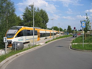
Lemgo-Lüttfeld is a railway station located in Lemgo, Germany. The station was opened on 28 July 2007 is located on the Bielefeld-Hameln railway. The train services are operated by Eurobahn.

Technische Hochschule OWL
Distance: Approx. 1381 meters
Latitude and longitude: 52.01611111,8.90527778
The Technische Hochschule Ostwestfalen-Lippe (abbreviated: THOWL) is a state tech university in the Ostwestfalen-Lippe area in Lemgo, which is part of North Rhine-Westphalia. Additional campuses are in Detmold and Höxter. About 6,600 students work closely with 173 professors and about 550 other staff members in research, teaching and administration.
Weather in this IP's area
light snow
-0 Celsius
-0 Celsius
-0 Celsius
0 Celsius
1008 hPa
91 %
1008 hPa
987 hPa
10000 meters
0.89 m/s
3.58 m/s
136 degree
100 %