Country:
Region:
City:
Latitude and Longitude:
Time Zone:
Postal Code:
IP information under different IP Channel
ip-api
Country
Region
City
ASN
Time Zone
ISP
Blacklist
Proxy
Latitude
Longitude
Postal
Route
Luminati
Country
Region
ia
City
iowacity
ASN
Time Zone
America/Chicago
ISP
IMONC
Latitude
Longitude
Postal
IPinfo
Country
Region
City
ASN
Time Zone
ISP
Blacklist
Proxy
Latitude
Longitude
Postal
Route
db-ip
Country
Region
City
ASN
Time Zone
ISP
Blacklist
Proxy
Latitude
Longitude
Postal
Route
ipdata
Country
Region
City
ASN
Time Zone
ISP
Blacklist
Proxy
Latitude
Longitude
Postal
Route
Popular places and events near this IP address

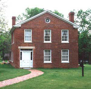
Plum Grove Historic House
Historic house in Iowa, United States
Distance: Approx. 2174 meters
Latitude and longitude: 41.64777778,-91.52444444
Plum Grove is a historic house located in Iowa City, United States. Plum Grove was the retirement home of Gov. Robert Lucas and the childhood home of the author Eleanor Hoyt Brainerd.

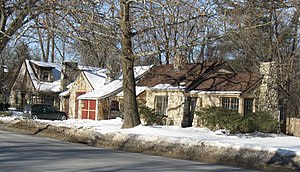
Muscatine Avenue Moffitt Cottage Historic District
Historic district in Iowa, US
Distance: Approx. 2670 meters
Latitude and longitude: 41.65722222,-91.51527778
The Muscatine Avenue Moffitt Cottage Historic District is a National Register of Historic Places district that includes five stone cottages in Iowa City epitomizing the eccentric vernacular architectural style of Howard Moffitt. Moffitt constructed more than 100 houses in Iowa City and Coralville, Iowa, and a few in Citrus City, Texas. These small houses represent one of the regional 20th-century vernacular architectural styles in the United States.
Murder of Shao Tong
2014 murder in Iowa; defendant convicted in China
Distance: Approx. 514 meters
Latitude and longitude: 41.63539,-91.49937
On September 26, 2014, police found a body later identified as 19-year-old Shao Tong (Chinese: 邵童, November 1994 – September 2014), a Chinese undergraduate at Iowa State University (ISU), in the trunk of a car registered in her name parked in an apartment complex on the outskirts of Iowa City, Iowa. She had been reported missing nine days earlier. The cause of death was found to be homicide by suffocation.
Murder of Yangjie Li
Crime in Germany
Distance: Approx. 514 meters
Latitude and longitude: 41.63539,-91.49937
The murder of Yangjie Li (simplified Chinese: 李洋洁; traditional Chinese: 李洋潔; pinyin: Lǐ Yángjié), a Chinese architecture student, occurred sometime during 11–13 May 2016 in Saxony-Anhalt, Germany. The event generated substantial media attention in Mainland China. A German man, Sebastian Flech, was convicted of the murder in 2017.

Clark House (Iowa City, Iowa)
Historic house in Iowa, United States
Distance: Approx. 2191 meters
Latitude and longitude: 41.64908333,-91.52294444
The Clark House is a historic building located in Iowa City, Iowa, United States. This property was originally part of Plum Grove, the estate of Iowa's first Territorial Governor, Robert Lucas. This lot was eventually sold to Florence A. Clark in 1870.

Kirkwood House
Historic house in Iowa, United States
Distance: Approx. 2006 meters
Latitude and longitude: 41.64902778,-91.51947222
The Kirkwood House is a historic building located in Iowa City, Iowa, United States. It was built for the local attorney and businessman Samuel J. Kirkwood who also served as Governor of Iowa, represented Iowa in the United States Senate, and was Secretary of the Interior in the cabinet of President James A. Garfield. The house was built after his second term as governor and remained his home until his death in 1893.

Oakes-Wood House
Historic house in Iowa, United States
Distance: Approx. 2728 meters
Latitude and longitude: 41.65697222,-91.51816667
The Oakes-Wood House, also known as the Grant Wood House, is a historic building located in Iowa City, Iowa, United States. Nicholas Oakes, who established one of the first brickyards in town, built this house in 1858. The two-story brick Italianate structure features a T-shape floor plan, low gable roof, bracketed eaves, and three brick chimneys.

James McCollister Farmstead
United States historic place
Distance: Approx. 1978 meters
Latitude and longitude: 41.63416667,-91.52916667
The James McCollister Farmstead, also known as the Old Charlie Showers Place, is a historic farmstead located in Iowa City, Iowa, United States. This property was first settled in 1840 by Philip Clark. He laid a claim on the land in 1836, but it was not available until after the Second Black Hawk Purchase of land from the Sauk, Meskwaki (Fox), and Ho-Chunk (Winnebago) tribes in 1837.

Longfellow Historic District
Historic district in Iowa, United States
Distance: Approx. 2411 meters
Latitude and longitude: 41.65444444,-91.51638889
The Longfellow Historic District is a nationally recognized historic district located in Iowa City, Iowa, United States. It was listed on the National Register of Historic Places in 2002. At the time of its nomination, it consisted of 355 resources, which included 250 contributing buildings, 103 non-contributing buildings, and two non-contributing structures.

Melrose Historic District (Iowa City, Iowa)
Historic district in Iowa, United States
Distance: Approx. 2411 meters
Latitude and longitude: 41.65444444,-91.51638889
The Melrose Historic District is a nationally recognized historic district located in Iowa City, Iowa, United States. It was listed on the National Register of Historic Places in 2004. At the time of its nomination it consisted of 134 resources, which included 112 contributing buildings, one contributing site, 20 non-contributing buildings, and one non-contributing structure.

South Summit Street District
Historic district in Iowa, United States
Distance: Approx. 2586 meters
Latitude and longitude: 41.65444444,-91.52111111
The South Summit Street District is a nationally recognized historic district located in Iowa City, Iowa, United States. It was listed on the National Register of Historic Places in 1973. At the time of its nomination it consisted of 50 contributing buildings, most of which were built between 1860 and 1910.
Elizabeth Tate Alternative High School
Public secondary school in Iowa City, Iowa, United States
Distance: Approx. 768 meters
Latitude and longitude: 41.64,-91.5
Elizabeth Tate Alternative High School (Tate High School) is an alternative high school in Iowa City, Iowa, that is part of the Iowa City Community School District. The school serves grades 9-12, with an enrollment of 164 students in the 2022-23 school year.
Weather in this IP's area
overcast clouds
12 Celsius
11 Celsius
10 Celsius
12 Celsius
1018 hPa
76 %
1018 hPa
992 hPa
10000 meters
1.34 m/s
4.02 m/s
96 degree
100 %
06:48:25
16:51:29