Country:
Region:
City:
Latitude and Longitude:
Time Zone:
Postal Code:
IP information under different IP Channel
ip-api
Country
Region
City
ASN
Time Zone
ISP
Blacklist
Proxy
Latitude
Longitude
Postal
Route
Luminati
Country
Region
ny
City
brooklyn
ASN
Time Zone
America/New_York
ISP
CORESITE
Latitude
Longitude
Postal
IPinfo
Country
Region
City
ASN
Time Zone
ISP
Blacklist
Proxy
Latitude
Longitude
Postal
Route
db-ip
Country
Region
City
ASN
Time Zone
ISP
Blacklist
Proxy
Latitude
Longitude
Postal
Route
ipdata
Country
Region
City
ASN
Time Zone
ISP
Blacklist
Proxy
Latitude
Longitude
Postal
Route
Popular places and events near this IP address

Cerritos, California
City in California, United States
Distance: Approx. 1141 meters
Latitude and longitude: 33.86833333,-118.0675
Cerritos (; Spanish for "Little hills") is a city in Los Angeles County, California, United States, and is one of several cities that constitute the Gateway Cities of southeast Los Angeles County. It was incorporated on April 24, 1956. As of 2019, the population was 49,859.
Cerritos High School
Public high school in the United States
Distance: Approx. 722 meters
Latitude and longitude: 33.864726,-118.063927
Cerritos High School, also called CHS, is a comprehensive, four-year public high school located in Cerritos, California, serving grades 9–12. It is part of the ABC Unified School District. As of the 2014–15 school year, the school had an enrollment of 2,176 students and 86.2 classroom teachers (on an FTE basis), for a student–teacher ratio of 25.2:1.
Artesia High School (California)
Public high school in Lakewood, California, United States
Distance: Approx. 1695 meters
Latitude and longitude: 33.845571,-118.075065
Artesia High School is a public high school in Lakewood, California, with a student population of around 1,500. It is one of the five high schools in the ABC Unified School District.

Cerritos Center for the Performing Arts
Entertainment venue in California, U.S.
Distance: Approx. 1079 meters
Latitude and longitude: 33.86759,-118.06168
The Cerritos Center for the Performing Arts (or CCPA) is a 154,000-square-foot (14,300 m2) entertainment and music venue located in the Cerritos Towne Center of Cerritos, California. It is owned and operated by the City of Cerritos and it opened its doors to the public on January 9, 1993, and hosts opera, cabaret, jazz, dance, magic, drama, musicals and comedy performances as well as private functions. Its season runs from August of one year to May of the following year.

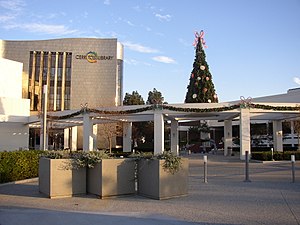
Cerritos Library
Public library in Cerritos, California
Distance: Approx. 969 meters
Latitude and longitude: 33.867001,-118.064797
The Cerritos Library is the civic library for the City of Cerritos, California, United States. It was rededicated on March 16, 2002, with the new moniker and the current futuristic design. It feature an exterior clad with titanium panels.
Cerritos Towne Center
Retail park in Cerritos, California, U.S.
Distance: Approx. 1588 meters
Latitude and longitude: 33.871904,-118.059822
The Cerritos Towne Center is a retail park located in the center of Cerritos, California that combines retailing, office, and entertainment in one master project. The Cerritos Center for the Performing Arts is located within the southwestern part of the project.
Pat Nixon Park
Childhood home of Pat Nixon
Distance: Approx. 279 meters
Latitude and longitude: 33.85834,-118.06802
Pat Nixon Park is a neighborhood park in Cerritos, California, named for the late First Lady Pat Nixon (1912-1993). The 4-acre (1.6 ha) park occupies the site of the former First Lady's childhood home and truck farm, where she lived from 1914 until 1931, a Senior Center that now sits on the site of the home after it was destroyed by a fire in 1978, and the Patricia Nixon Elementary School.
Cerritos Veterans Memorial
Veterans memorial located in California, U.S.A.
Distance: Approx. 877 meters
Latitude and longitude: 33.86616389,-118.06437222
The Cerritos Veterans Memorial, located in Cerritos, California is a 20-foot-high (6.1 m) sculpture dedicated in honor of local veterans. The sculpture is part of a "Cerritos Veterans Project," which seeks to preserve the stories of veterans who are current or former residents of the City of Cerritos. The sculpture, which was designed and built by artist James T. Russell, sits on the grounds of the Cerritos Civic Center.

Don Knabe Community Regional Park
Park in Cerritos, California
Distance: Approx. 995 meters
Latitude and longitude: 33.850185,-118.060498
Don Knabe Community Regional Park, previously known as Cerritos Community Regional Park, is an urban park in Cerritos, California. It contains a few large sculptures, two fishing lakes, and many other amenities. The park was retitled to its current name on November 30, 2016, to honor the former supervisor Don Knabe.

Holy Family Catholic Church (Artesia, California)
Church in Artesia, California
Distance: Approx. 1409 meters
Latitude and longitude: 33.8622,-118.0795
Holy Family Catholic Church is a Catholic church located in Artesia, California. Established in 1930, it holds masses in English, Spanish, Tagalog, Portuguese, and Mandarin Chinese. It is named after the Holy Family of Jesus and is a part of the San Pedro Pastoral Region in the Archdiocese of Los Angeles.

Heritage Park (Cerritos, California)
Park in California
Distance: Approx. 727 meters
Latitude and longitude: 33.8643,-118.0619
Heritage Park is an urban park in Cerritos, California. It measures 15 acres (6.1 ha) in area. It is close to the center of the city, with Cerritos High School, Cerritos Library, and Cerritos Towne Center all located nearby.

Artesia Water Tower
Water tower in California
Distance: Approx. 1523 meters
Latitude and longitude: 33.8651,-118.0793
The Artesia Water Tower is a water tower in Artesia, California. It is one of the main landmarks in the city and can hold 50,000 US gal (190,000 L), although it is inactive. Not much is known about the tower's history.
Weather in this IP's area
clear sky
18 Celsius
17 Celsius
16 Celsius
20 Celsius
1012 hPa
41 %
1012 hPa
1010 hPa
10000 meters
3.09 m/s
180 degree
06:26:08
16:48:26
