97.68.25.38 - IP Lookup: Free IP Address Lookup, Postal Code Lookup, IP Location Lookup, IP ASN, Public IP
Country:
Region:
City:
Location:
Time Zone:
Postal Code:
IP information under different IP Channel
ip-api
Country
Region
City
ASN
Time Zone
ISP
Blacklist
Proxy
Latitude
Longitude
Postal
Route
Luminati
Country
Region
fl
City
orlando
ASN
Time Zone
America/New_York
ISP
BHN-33363
Latitude
Longitude
Postal
IPinfo
Country
Region
City
ASN
Time Zone
ISP
Blacklist
Proxy
Latitude
Longitude
Postal
Route
IP2Location
97.68.25.38Country
Region
florida
City
port orange
Time Zone
America/New_York
ISP
Language
User-Agent
Latitude
Longitude
Postal
db-ip
Country
Region
City
ASN
Time Zone
ISP
Blacklist
Proxy
Latitude
Longitude
Postal
Route
ipdata
Country
Region
City
ASN
Time Zone
ISP
Blacklist
Proxy
Latitude
Longitude
Postal
Route
Popular places and events near this IP address

Port Orange, Florida
City in Florida, United States
Distance: Approx. 2271 meters
Latitude and longitude: 29.11888889,-81.00277778
Port Orange is a city in Volusia County, Florida, United States. The city is part of the Deltona–Daytona Beach–Ormond Beach metropolitan area. Port Orange is a principal city in the Fun Coast region of the state of Florida.

South Daytona, Florida
City in Florida, United States
Distance: Approx. 3280 meters
Latitude and longitude: 29.16527778,-81.00916667
South Daytona is a city in Volusia County, Florida, United States. The population was 12,865 at the 2020 census.
Allandale, Florida
Unincorporated community in Florida, U.S.
Distance: Approx. 2630 meters
Latitude and longitude: 29.12166667,-80.97638889
Allandale is an unincorporated community in Volusia County, Florida, United States. Allandale is surrounded on three sides by the city of Port Orange, with the remainder bordering the Halifax River.

Dunlawton Avenue Historic District
Historic district in Florida, United States
Distance: Approx. 599 meters
Latitude and longitude: 29.14222222,-80.99138889
The Dunlawton Avenue Historic District is a U.S. historic district (designated as such on February 5, 1998) located in Port Orange, Florida. The district runs roughly along Dunlawton Avenue to Lafayette Avenue, and Orange Avenue and Wellman Street. It contains 17 historic buildings.

Halifax Drive Historic District
United States historic place
Distance: Approx. 1073 meters
Latitude and longitude: 29.14361111,-80.98638889
The Halifax Drive Historic District was a U.S. historic district (designated as such on February 5, 1998) located in Port Orange, Florida. The district ran roughly along Halifax Drive from Dunlawton to Herbert Street. It contained 17 historic buildings.
WDJZ
Radio station in South Daytona, Florida
Distance: Approx. 3151 meters
Latitude and longitude: 29.15444444,-81.02222222
WDJZ (1590 AM) is a commercial radio station licensed to South Daytona, Florida, and serving the Daytona Beach metropolitan area. It is owned by Glenn Cherry and it broadcasts a smooth jazz radio format. WDJZ is powered at 1,000 watts by day, 47 watts at night, using a non-directional antenna.

Dunlawton Plantation and Sugar Mill
United States historic place
Distance: Approx. 1060 meters
Latitude and longitude: 29.14083333,-81.00611111
The Dunlawton Plantation and Sugar Mill, a 19th-century cane sugar plantation in north-central Florida, was destroyed by the Seminoles at the beginning of the Second Seminole War. The ruins are located at 950 Old Sugar Mill Road, Port Orange, Florida. On August 28, 1973, the site was added to the United States National Register of Historic Places under the title of Dunlawton Plantation-Sugar Mill Ruins.

Port Orange station
United States historic place
Distance: Approx. 612 meters
Latitude and longitude: 29.14333333,-80.99305556
Port Orange Florida East Coast Railway Freight Depot is a historic Florida East Coast Railway passenger depot in Port Orange, Florida, United States. It is located at 415C Herbert Street, off U.S. 1. The depot was originally constructed in 1894 as two buildings.

Grace Episcopal Church and Guild Hall (Port Orange, Florida)
Historic church in Florida, United States
Distance: Approx. 971 meters
Latitude and longitude: 29.14305556,-80.98722222
Grace Episcopal Church and Guild Hall is a historic site in Port Orange, Florida, United States. It is located at 4100 Ridgewood Avenue. On February 5, 1998, it was added to the U.S. National Register of Historic Places.
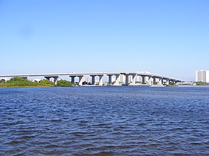
Port Orange Causeway
Bridge in Florida, United States of America
Distance: Approx. 2231 meters
Latitude and longitude: 29.14805556,-80.97555556
The Port Orange Causeway, commonly called the Port Orange Bridge or the Dunlawton Bridge, spans the Halifax River and Intracoastal Waterway in Port Orange, Volusia County, Florida. The bridge carries approximately 29,000 vehicles per day across four lanes of State Road A1A and Dunlawton Avenue.
Mount Moriah Baptist Church (Port Orange, Florida)
Distance: Approx. 1127 meters
Latitude and longitude: 29.1483,-80.9938
Mount Moriah Baptist Church was built in Port Orange, Florida in 1911. Built to serve black residents, it was located in an area that came to be known as Freemanville and is believed to be the last remaining building from the settlement. Freed blacks settled the area to work at a lumber company started by John Milton Hawks, but sandy soil, corruption, and planning issues led to a rapid decline as the colony struggled.
Freemanville, Florida
Distance: Approx. 1127 meters
Latitude and longitude: 29.1483,-80.9938
Freemanville is a section of Port Orange, Florida, settled by freed blacks after the U.S. Civil War. John Milton Hawks brought freed blacks to the area to work at his sawmill, but various issues caused it to fail, leading to struggles for the colony. Despite these challenges, some colonists remained and settled the area that became known as Freemanville.
Weather in this IP's area
scattered clouds
11 Celsius
10 Celsius
10 Celsius
11 Celsius
1023 hPa
81 %
1023 hPa
1022 hPa
10000 meters
4.47 m/s
5.81 m/s
309 degree
40 %
