96.9.87.60 - IP Lookup: Free IP Address Lookup, Postal Code Lookup, IP Location Lookup, IP ASN, Public IP
Country:
Region:
City:
Location:
Time Zone:
Postal Code:
ISP:
ASN:
language:
User-Agent:
Proxy IP:
Blacklist:
IP information under different IP Channel
ip-api
Country
Region
City
ASN
Time Zone
ISP
Blacklist
Proxy
Latitude
Longitude
Postal
Route
db-ip
Country
Region
City
ASN
Time Zone
ISP
Blacklist
Proxy
Latitude
Longitude
Postal
Route
IPinfo
Country
Region
City
ASN
Time Zone
ISP
Blacklist
Proxy
Latitude
Longitude
Postal
Route
IP2Location
96.9.87.60Country
Region
baat dambang
City
battambang
Time Zone
Asia/Phnom_Penh
ISP
Language
User-Agent
Latitude
Longitude
Postal
ipdata
Country
Region
City
ASN
Time Zone
ISP
Blacklist
Proxy
Latitude
Longitude
Postal
Route
Popular places and events near this IP address
Battambang
City in Cambodia
Distance: Approx. 358 meters
Latitude and longitude: 13.1,103.2
Battambang (Khmer: បាត់ដំបង, UNGEGN: Bătdâmbâng [ɓatɗɑmɓɑːŋ]) is the capital of Battambang Province and the third largest city in Cambodia. Founded in the 11th century by the Khmer Empire, Battambang is the leading rice-producing province of the country. For nearly 100 years, it was a major commercial hub and the capital of the Siamese province of Inner Cambodia (1795–1907), though it was always populated by Khmer people, with some ethnic Vietnamese, Lao, Thai, and Chinese.
Battambang Airport
Airport in Cambodia
Distance: Approx. 2926 meters
Latitude and longitude: 13.09555556,103.22416667
Battambang (Vealbekchan) Airport (Khmer: ព្រលានយន្តហោះវាលបែកចានខេត្តបាត់តំបង) (IATA: BBM, ICAO: VDBG) is an airport serving Battambang, a city in Battambang Province, Cambodia. The airport is 3 kilometers from the city center in Battambang. It has a total land area of 128.68 hectares.
Tuol Ta Aek
Quarter in Battambang Province, Cambodia
Distance: Approx. 2692 meters
Latitude and longitude: 13.08333333,103.18333333
Tuol Ta Aek (សង្កាត់ទួលតាឯក) is a khum (commune) of Battambang District in Battambang Province in north-western Cambodia.
Chamkar Samraong
Sangkat in Krong Battambang, Cambodia
Distance: Approx. 2538 meters
Latitude and longitude: 13.1214,103.1848
Chamkar Samraong (Khmer: ចំការសំរោង) is a sangkat (previously khum/commune) of Battambang Municipality (previously Battambang District) in Battambang Province in north-western Cambodia.
Sla Kaet
Commune in Battambang, Cambodia
Distance: Approx. 3954 meters
Latitude and longitude: 13.13333333,103.21666667
Sla Kaet (Khmer: ស្លាកែត) is a commune (sangkat) of Battambang Municipality in Battambang Province in north-western Cambodia.
Voat Kor
Commune in Battambang Province, Cambodia
Distance: Approx. 2165 meters
Latitude and longitude: 13.08333333,103.2
Voat Kor (Khmer: ឃុំវត្តគរ) is a khum (commune) of Battambang District in Battambang Province in north-western Cambodia. It is the birthplace of Nuon Chea, one of the leaders of the Khmer Rouge.
Ou Char
Commune in Battambang Province, Cambodia
Distance: Approx. 1640 meters
Latitude and longitude: 13.1,103.18333333
Ou Char (Khmer: ឃុំអូរចារ) is a khum (commune) of Battambang District in Battambang Province in north-western Cambodia.
Samraong Knong
Commune in Battambang Province, Cambodia
Distance: Approx. 3954 meters
Latitude and longitude: 13.13333333,103.21666667
Samraong Knong is a khum (commune) of Aek Phnum District in Battambang Province in north-western Cambodia.
Peam Aek
Commune in Battambang Province, Cambodia
Distance: Approx. 5633 meters
Latitude and longitude: 13.15,103.21666667
Peam Aek is a khum (commune) of Aek Phnum District in Battambang Province in north-western Cambodia. Close to this place is the temple site of Wat Ek Phnom.
Anlong Vil
Commune in Battambang, Cambodia
Distance: Approx. 4377 meters
Latitude and longitude: 13.08333333,103.23333333
Anlong Vil (Khmer: អន្លង់វិល) is a commune (khum) of Sangkae District in Battambang Province in north-western Cambodia.
Norea (commune)
Commune in Battambang, Cambodia
Distance: Approx. 2535 meters
Latitude and longitude: 13.11666667,103.21666667
Norea (Khmer: នរា) is a commune (khum) of Sangkae District in Battambang Province in north-western Cambodia.

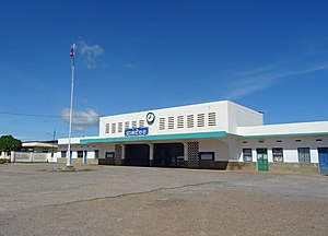
Battambang Royal railway station
Railway station in Battambang, Cambodia
Distance: Approx. 668 meters
Latitude and longitude: 13.097868,103.194539
Battambang Royal railway station is a railway station in Battambang, the capital city of Battambang province in northwestern Cambodia. It was opened in 1953 and is operated by Royal Railways of Cambodia (Chemins de Fer Royaux du Cambodge).
Weather in this IP's area
broken clouds
22 Celsius
22 Celsius
22 Celsius
22 Celsius
1009 hPa
75 %
1009 hPa
1007 hPa
10000 meters
1.64 m/s
1.71 m/s
279 degree
80 %