Country:
 USA
USARegion:
City:
Latitude and Longitude:
Time Zone:
Postal Code:
IP information under different IP Channel
ip-api
Country
Region
City
ASN
Time Zone
ISP
Blacklist
Proxy
Latitude
Longitude
Postal
Route
IPinfo
Country
Region
City
ASN
Time Zone
ISP
Blacklist
Proxy
Latitude
Longitude
Postal
Route
MaxMind
Country
Region
City
ASN
Time Zone
ISP
Blacklist
Proxy
Latitude
Longitude
Postal
Route
Luminati
Country
USASN
Time Zone
America/Chicago
ISP
ASN-DIS
Latitude
Longitude
Postal
db-ip
Country
Region
City
ASN
Time Zone
ISP
Blacklist
Proxy
Latitude
Longitude
Postal
Route
ipdata
Country
Region
City
ASN
Time Zone
ISP
Blacklist
Proxy
Latitude
Longitude
Postal
Route
Popular places and events near this IP address

Texas Stadium
Former stadium in Texas, United States
Distance: Approx. 3040 meters
Latitude and longitude: 32.83972222,-96.91083333
Texas Stadium was an American football stadium located in Irving, Texas, a suburb west of Dallas. Opened on October 24, 1971, it was known for its distinctive hole in the roof, the result of abandoned plans to construct a retractable roof. The stadium was the home field of the NFL's Dallas Cowboys for 38 seasons, through 2008, and had a seating capacity of 65,675.
American Airlines Flight 157
1949 aviation accident
Distance: Approx. 2791 meters
Latitude and longitude: 32.84805556,-96.85111111
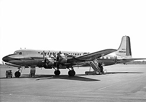
American Airlines Flight 157, a Douglas DC-6, departed on November 29, 1949, from New York City bound for Mexico City with 46 passengers and crew. After one engine failed in mid-flight, a series of critical mistakes by the flight crew caused the pilot to lose control of the plane during the final approach to a routine stopover at Love Field in Dallas, Texas. The airliner slid off the runway and struck a parked airplane, a hangar, and a flight school before crashing into a business across from the airport.

Bachman Lake
Artificial lake in Northwest Dallas, Texas
Distance: Approx. 1400 meters
Latitude and longitude: 32.84888889,-96.87111111
Bachman Lake is a small freshwater lake located in the Bachman Lake community of northwest Dallas, Texas (USA). It covers 205 acres (0.83 km2) and lies on the northwest boundary of Dallas Love Field in the airport's landing path and the western boundary of the upscale Bluffview neighborhood. At the Western end of the lake, DART provides transit service at Bachman Station, including light rail service via the Green Line and Orange Line.
Love Field, Dallas
Place in Texas, United States
Distance: Approx. 2231 meters
Latitude and longitude: 32.834,-96.855
Love Field is a neighborhood located in northwest Dallas, Texas (USA). It lies southwest of and is adjacent to Dallas Love Field Airport and is bounded by Denton Drive, Inwood Road, Harry Hines Boulevard, and Webb Chapel Extension. The neighborhood takes its name from Love Field Airport.
American Airlines Flight 910
1952 mid-air collision
Distance: Approx. 2791 meters
Latitude and longitude: 32.84805556,-96.85111111
American Airlines Flight 910, a four-engine Douglas DC-6 propliner, collided in mid-air with a single engine Temco Swift on final approach to Dallas Love Field on June 28, 1952, over Dallas, Texas. The DC-6 was carrying 55 passengers and 5 crew members from San Francisco, California. The DC-6 landed with no injuries to any of its 60 occupants, while both occupants of the two-person Swift died when their aircraft impacted the ground.
Consulate-General of Mexico, Dallas
Diplomatic mission of Mexico in Dallas, Texas, United States
Distance: Approx. 2779 meters
Latitude and longitude: 32.8163,-96.8635
The Consulate-General of Mexico in Dallas (Spanish: Consulado-General de México en Dallas) is a diplomatic mission of Mexico in Dallas, Texas, United States. In 2009, Alfredo Corchado of The Dallas Morning News called it the thirdmost important Mexican consulate after Los Angeles and Chicago's, in terms of activity and Mexican population size. It moved from 8855 North Stemmons Freeway to 1210 River Bend Drive that January.

Bachman station
DART light rail station in Dallas, Texas
Distance: Approx. 1800 meters
Latitude and longitude: 32.854044,-96.877338
Bachman station is a Dallas Area Rapid Transit station in Dallas, Texas. It serves DART's Green Line and Orange Line. The station opened as part of the Green Line's expansion in December 2010.

Burbank station (DART)
DART light rail station in Dallas, Texas
Distance: Approx. 1637 meters
Latitude and longitude: 32.842689,-96.861854
Burbank station is a DART light rail station located near Dallas Love Field airport for service on the Green Line and Orange Line. The station opened as part of the Green Line's expansion in December 2010, and serves the headquarters for Southwest Airlines and an adjacent residential neighborhood. This station was originally proposed to serve the airport terminal directly with an underground station (much like Cityplace/Uptown station), but a 2004 study showed that costs would be well beyond acceptable levels and jeopardize a federal grant.

Center for BrainHealth
Research institute
Distance: Approx. 3232 meters
Latitude and longitude: 32.82462,-96.847675
The Center for BrainHealth, part of The University of Texas at Dallas' school of Behavioral and Brain Sciences, is a research institute focused exclusively on brain health that combines brain research with clinical interventions. Founded by Dr. Sandra Bond Chapman in 1999, the Center for BrainHealth houses 125 researchers, postdoctoral research fellows, doctoral students, master's students, and research clinicians who work on 60 privately and federally funded research projects.
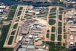
Dallas Love Field
Municipal airport in Dallas, Texas, United States
Distance: Approx. 2707 meters
Latitude and longitude: 32.84722222,-96.85166667
Dallas Love Field (IATA: DAL, ICAO: KDAL, FAA LID: DAL) is a city-owned public airport in the neighborhood of Love Field, 6 miles (9.7 km; 5.2 nmi) northwest of downtown Dallas, Texas. It was Dallas' main airport until 1974 when Dallas Fort Worth International Airport (DFW) opened. Love Field covers an area of 1,300 acres (530 ha) at an elevation of 487 feet (148 m) above mean sea level and has two runways.

Gas Monkey Bar N' Grill
American restaurant and live music bar in Dallas, Texas
Distance: Approx. 3039 meters
Latitude and longitude: 32.8608,-96.8961
Gas Monkey Bar N' Grill was an American restaurant and live music bar in Dallas, Texas started by entrepreneur Richard Rawlings, who is also the star of Discovery Channel reality television show Fast N' Loud.

Gas Monkey Live
Music venue in Dallas, Texas, 2014–2020
Distance: Approx. 2598 meters
Latitude and longitude: 32.8577,-96.8931
Gas Monkey Live was an American music venue in Dallas, Texas, owned by Richard Rawlings, star of American television program Fast N' Loud and owner of both Gas Monkey Garage and Gas Monkey Bar N' Grill.
Weather in this IP's area
clear sky
19 Celsius
18 Celsius
18 Celsius
21 Celsius
1025 hPa
39 %
1025 hPa
1010 hPa
10000 meters
6.69 m/s
9.77 m/s
120 degree
07:34:08
18:50:38