Country:
Region:
City:
Latitude and Longitude:
Time Zone:
Postal Code:
IP information under different IP Channel
ip-api
Country
Region
City
ASN
Time Zone
ISP
Blacklist
Proxy
Latitude
Longitude
Postal
Route
Luminati
Country
ASN
Time Zone
America/Chicago
ISP
NTT-GLOBAL-DATA-CENTERS-AMERICA-INC
Latitude
Longitude
Postal
IPinfo
Country
Region
City
ASN
Time Zone
ISP
Blacklist
Proxy
Latitude
Longitude
Postal
Route
db-ip
Country
Region
City
ASN
Time Zone
ISP
Blacklist
Proxy
Latitude
Longitude
Postal
Route
ipdata
Country
Region
City
ASN
Time Zone
ISP
Blacklist
Proxy
Latitude
Longitude
Postal
Route
Popular places and events near this IP address
Folsom High School
Public school in Folsom, California, United States
Distance: Approx. 2146 meters
Latitude and longitude: 38.649,-121.156
Folsom High School is a public secondary school in the western United States, located in Folsom, California, a suburb east of Sacramento. Established 102 years ago in 1922, it is a part of the Folsom Cordova Unified School District.
Hawkins' School of Performing Arts
Ballet school in Folsom, California
Distance: Approx. 544 meters
Latitude and longitude: 38.65694444,-121.18444444
Hawkins' School of Performing Arts is primarily a ballet school in Folsom, California, USA. It is the ballet school and training space for the Folsom Lake Civic Ballet.

Sacramento California Temple
LDS temple
Distance: Approx. 2378 meters
Latitude and longitude: 38.63511111,-121.19391667
The Sacramento California Temple is the 123rd operating temple of the Church of Jesus Christ of Latter-day Saints (LDS Church). The temple was the seventh built by the church in California, more than any state except Utah. The Sacramento California Temple serves a membership which totals approximately 80,000 in the area.
Lake Natoma
Reservoir in Sacramento County, California
Distance: Approx. 1045 meters
Latitude and longitude: 38.654,-121.192
Lake Natoma is a small lake in the Western United States, along the lower American River, between Folsom and Nimbus Dams in Sacramento County, California. The lake is located within the Folsom Lake State Recreation Area which maintains the facilities and bike trails surrounding the lake. Lake Natoma is located 15 miles (24 km) east of Sacramento, and has 500 surface acres of water.

Iron Point station
SacRT light rail station
Distance: Approx. 1324 meters
Latitude and longitude: 38.64472222,-121.19027778
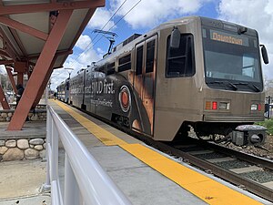
Iron Point station is a side platformed SacRT light rail station in Folsom, California, United States. The station was opened on October 15, 2005, and is operated by the Sacramento Regional Transit District. It is served by the Gold Line.

Glenn station
Light rail station in Folsom, California, United States
Distance: Approx. 1109 meters
Latitude and longitude: 38.66305556,-121.18361111
Glenn station (also known as Glenn/Robert G Holderness station) is a side platformed SacRT light rail station in Folsom, California, United States. The station was opened on October 15, 2005, and is operated by the Sacramento Regional Transit District. It is served by the Gold Line.

Historic Folsom station
Light rail station in Folsom, California, U.S.
Distance: Approx. 2487 meters
Latitude and longitude: 38.67583333,-121.18055556
Historic Folsom station is a side platformed SacRT light rail station in Folsom, California, United States. The station was opened on October 15, 2005, is operated by the Sacramento Regional Transit District and is the current eastern terminus of the Gold Line. The station is located near the intersection of Sutter Street and Reading Street, adjacent to the Western-themed city center.
Rancho Río de los Americanos
Former Mexican land grant in Sacramento, California
Distance: Approx. 2032 meters
Latitude and longitude: 38.67,-121.19
Rancho Río de los Americanos was a 35,521-acre (143.75 km2) Mexican land grant in present-day Sacramento County, California given in 1844 by Governor Manuel Micheltorena to William Leidesdorff (1810–1848). The grant takes its name from Río de los Americanos, the name of the American River during the Mexican-rule era. The grant originally consisted of 8 square leagues and extended from the eastern border of John Sutter's New Helvetia (east of Sacramento) 4 leagues along the south bank of the American River, to the eastern end of present-day Folsom, and included present-day cities of Rancho Cordova and Folsom.

Chung Wah Cemetery
Historic cemetery in Folsom, California
Distance: Approx. 2230 meters
Latitude and longitude: 38.67333333,-121.18361111
The Chung Wah Cemetery, also known as China Mission-Chung Wah Chinese Cemetery, in Folsom, California is a cemetery from 1906. The city of Folsom had a thriving Chinese community of about 3,000 that was drawn by the gold mining in the area. The size and shape of the cemetery suggests that it was not planned well.

Willow Creek (Sacramento County, California)
River in Folsom, California
Distance: Approx. 1061 meters
Latitude and longitude: 38.6499,-121.1913
Willow Creek in Folsom, California flows into Lake Natoma. The Humbug Willow Creek trail offers walking and cycling along the creek.

Murer House and Gardens
Historic house in California, United States
Distance: Approx. 2227 meters
Latitude and longitude: 38.67342222,-121.18229167
The Murer House and Gardens in Folsom, California is a building, designed and built by Giuseppe Murer in the Italian Renaissance architecture style, built in 1927. The house currently operates as a museum, and showcases the history of Italian immigration to the US and the early formation of Folsom. The Murer House and Gardens was listed on the National Register of Historic Places in 2022.
Southern Pacific Railroad Section Superintendent House
Historic house in California, United States
Distance: Approx. 1814 meters
Latitude and longitude: 38.66972222,-121.18194444
The Southern Pacific Railroad Section Superintendent House located in Folsom, California is a historic company housing building built by the Southern Pacific Railroad for the section superintendent and his family that oversaw the Folsom junction railroad operations. The house was in use as the superintendent's house until the 1950, and as a residence until 2002.
Weather in this IP's area
clear sky
13 Celsius
12 Celsius
10 Celsius
18 Celsius
1022 hPa
56 %
1022 hPa
1015 hPa
10000 meters
06:39:50
16:57:15

