Country:
 country.xk
Region:
City:
Latitude and Longitude:
Time Zone:
Postal Code:
IP information under different IP Channel
ip-api
Country
Region
City
ASN
Time Zone
ISP
Blacklist
Proxy
Latitude
Longitude
Postal
Route
IPinfo
Country
Region
City
ASN
Time Zone
ISP
Blacklist
Proxy
Latitude
Longitude
Postal
Route
MaxMind
Country
Region
City
ASN
Time Zone
ISP
Blacklist
Proxy
Latitude
Longitude
Postal
Route
Luminati
Country
XKCity
pristina
ASN
Time Zone
Europe/Belgrade
ISP
TelKos L.L.C
Latitude
Longitude
Postal
db-ip
Country
Region
City
ASN
Time Zone
ISP
Blacklist
Proxy
Latitude
Longitude
Postal
Route
ipdata
Country
Region
City
ASN
Time Zone
ISP
Blacklist
Proxy
Latitude
Longitude
Postal
Route
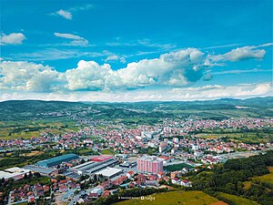
Popular places and events near this IP address

Rahovec
Town and municipality in District of Gjakova, Kosovo
Distance: Approx. 7545 meters
Latitude and longitude: 42.39944444,20.65472222
Rahovec (Albanian definite form: Rahoveci) or Orahovac (Serbian Cyrillic: Ораховац), is a town and municipality located in the District of Gjakova in western Kosovo. According to the 2011 census, the town of Rahovec has 15,892 inhabitants, while the municipality has 56,208 inhabitants.
Suva Reka
Town and municipality in Prizren, Kosovo
Distance: Approx. 7925 meters
Latitude and longitude: 42.38,20.82194444
Suva Reka (Serbian Cyrillic: Сува Река) or Suharekë (Albanian definite form: Suhareka) or Therandë (Albanian definite form: Theranda) is a town and municipality located in the Prizren district of central-southern Kosovo. According to the 2011 census, the town has 10,422 inhabitants, while the municipality has 59,722 inhabitants. Suva Reka is located 18 km (11 mi) from the city of Prizren, and 57 km (35 mi) from Kosovo's capital, Pristina.
Hoçë e Madhe
Village in Gjakova, Kosovo
Distance: Approx. 6699 meters
Latitude and longitude: 42.3842,20.6767
Hoçë e Madhe (Serbian Cyrillic: Велика Хоча) is a village in the municipality of Rahovec, in Kosovo. It was one of the Serb enclaves in Kosovo, and houses some 13 Orthodox church buildings, most of which date to the Serbian Middle Ages. The village has 124 inhabitants, of whom 75 are ethnic Albanians and 49 are Serbs according to the 2011 census.
Studençan
Village in Prizren District, Kosovo
Distance: Approx. 6966 meters
Latitude and longitude: 42.35861111,20.75861111
Studençan (Serbian: Studenčane, Serbian Cyrillic: Студенчане) is a village in the municipality of Suva Reka, Kosovo. The new name was given after the Kosovo War. Studençan is close to Suva Reka, 5 km west.
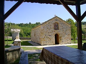
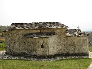
Zočište Monastery
Distance: Approx. 5965 meters
Latitude and longitude: 42.37527778,20.70222222
The Zočište Monastery (Serbian: Манастир Зочиште, romanized: Manastir Zočište; Albanian: Manastiri i Zoçishtës) or formally St. Cosmas and Damian's Monastery (Serbian: Манастир Св. Козме и Дамјана, romanized: Manastir Sv.
Banjë, Malishevë
Village in Prizren, Kosovo
Distance: Approx. 5797 meters
Latitude and longitude: 42.464385,20.779106
Banja (Albanian: Banjë;Serbian: Бања) is a village in municipality of Malisheva in Republic of Kosovo. The village has an area of 1305 ha. The village is named after a local spring with warm water that has healing properties.
KF Malisheva
Kosovo football club
Distance: Approx. 7072 meters
Latitude and longitude: 42.4822,20.7247
Klubi Futbollistik Malisheva (transl. Football Club Malisheva), commonly known as Malisheva, is a professional football club based in Malisheva, Kosovo and their home ground is the Liman Gegaj Stadium which has a seating capacity of 1,800. The club plays in the Football Superleague of Kosovo, which is the top tier of football in the country.
Peqan
Village in Prizren, Kosovo
Distance: Approx. 7846 meters
Latitude and longitude: 42.382499,20.823013
Peqan (Albanian: Peqan, Serbian Cyrillic: Пећане/Pećane) is a village in Suharekë municipality, Kosovo.
Samadrexhë
Village in Prizren, Kosovo
Distance: Approx. 6279 meters
Latitude and longitude: 42.36361111,20.74027778
Samadrexhë (Albanian: Samadrexhë, Serbian Cyrillic: Самодража/Samodraža) is a village in Suharekë municipality, Kosovo.
Astrazup
Village in Prizren, Kosovo
Distance: Approx. 4762 meters
Latitude and longitude: 42.447797,20.698146
Astrazup (Albanian: Astrazup, Serbian Cyrillic: Острозуб/Ostrozub) is a village in Malishevë municipality, Kosovo.
Zočište
Village in Gjakova, Kosovo
Distance: Approx. 5965 meters
Latitude and longitude: 42.37527778,20.70222222
Zočište (Serbian Cyrillic: Зочиште; Albanian: Zoçishtë) is a village in the Gjakova Municipality in western Kosovo.

Kasterc Fortress
Fortress in Kosovo
Distance: Approx. 4193 meters
Latitude and longitude: 42.4146,20.7927
The Kasterc Fortress site (Albanian: Kalaja e Kastercit) is an archeological site at the location of a former fortress in Kosovo.
Weather in this IP's area
overcast clouds
14 Celsius
14 Celsius
14 Celsius
15 Celsius
1018 hPa
92 %
1018 hPa
955 hPa
10000 meters
1.01 m/s
1.03 m/s
43 degree
100 %
06:22:28
18:38:24