Country:
Region:
City:
Latitude and Longitude:
Time Zone:
Postal Code:
IP information under different IP Channel
ip-api
Country
Region
City
ASN
Time Zone
ISP
Blacklist
Proxy
Latitude
Longitude
Postal
Route
Luminati
Country
Region
vic
ASN
Time Zone
Australia/Melbourne
ISP
Kinetix Networks
Latitude
Longitude
Postal
IPinfo
Country
Region
City
ASN
Time Zone
ISP
Blacklist
Proxy
Latitude
Longitude
Postal
Route
db-ip
Country
Region
City
ASN
Time Zone
ISP
Blacklist
Proxy
Latitude
Longitude
Postal
Route
ipdata
Country
Region
City
ASN
Time Zone
ISP
Blacklist
Proxy
Latitude
Longitude
Postal
Route
Popular places and events near this IP address

Timeline of Melbourne history
Distance: Approx. 142 meters
Latitude and longitude: -37.814167,144.963056
The following is a timeline of the history of the city of Melbourne, Victoria, Australia.

Hoddle Grid
Layout of the Melbourne central business district
Distance: Approx. 142 meters
Latitude and longitude: -37.81416667,144.96305556
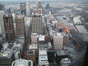
The Hoddle Grid is the contemporary name given to the approximately 1.61-by-0.80-kilometre (1.00 mi × 0.50 mi) grid of streets that form the Melbourne central business district, Australia. Bounded by Flinders Street, Spring Street, La Trobe Street, and Spencer Street, it lies at an angle to the rest of the Melbourne suburban grid, and so is easily recognisable. It is named after the surveyor Robert Hoddle, who marked it out in 1837 (to Lonsdale Street, extended to La Trobe Street the next year), based on the city grid established in the first survey of Melbourne conducted by Robert Russell (architect) in 1836, establishing the first formal town plan.

385 Bourke Street
High-rise office building located in Melbourne, Australia
Distance: Approx. 109 meters
Latitude and longitude: -37.814776,144.962888
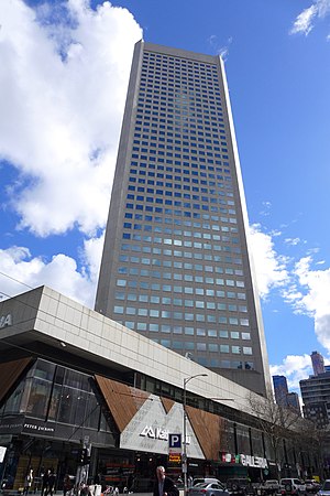
385 Bourke Street is a high-rise office building located in Melbourne, Australia, located at 385 Bourke Street, on the corner of Elizabeth Street. It was built in 1975-1983 as the State Bank Centre, the head office of the State Bank of Victoria, which was taken over by the Commonwealth Bank of Australia in 1990. It replaced their previous headquarters, a classical style office building, built in stages between 1912 and 1935.

Royal Arcade, Melbourne
Shopping arcade in Melbourne, Victoria
Distance: Approx. 78 meters
Latitude and longitude: -37.8145,144.9641
The Royal Arcade is a historic shopping arcade in the central business district of Melbourne, Victoria, Australia. Opened in 1870, it connects Bourke Street Mall to Little Collins Street, with a side offshoot to Elizabeth Street. It is the oldest surviving arcade in Australia, known for its elegant light-filled interior, and the large carved mythic figures of Gog and Magog flanking the southern entry.

Howey Place
Shopping arcade in Melbourne, Victoria
Distance: Approx. 125 meters
Latitude and longitude: -37.81527778,144.96541667
Howey Place, formerly known as "Cole's Walk" is a shopping arcade in Melbourne, Victoria. It is a short, narrow covered laneway, running south from Little Collins Street between Swanston Street and Elizabeth Street in the central business district of Melbourne. Located in the heart of the shopping precinct, Howey Place is currently flanked with small designer fashion shops.

Block Place
Street in Melbourne, Victoria
Distance: Approx. 28 meters
Latitude and longitude: -37.81527778,144.96430556
Block Place is a street in Melbourne. It is a short, narrow partially covered laneway, running south from Little Collins Street between Swanston Street and Elizabeth streets in the Melbourne central business district. Block Place is a pedestrian only laneway that is trendy and popular with both Melbourne locals and tourists for its intimate alfresco cafes close to the shopping heart of Melbourne it is crowded with cafes and shops in a number of pre-war buildings.

Block Arcade, Melbourne
Shopping centre in Melbourne, Australia
Distance: Approx. 81 meters
Latitude and longitude: -37.81583333,144.96444444
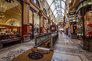
The Block Arcade is a historic shopping arcade in the central business district of Melbourne, Victoria, Australia. Constructed between 1891 and 1893, it is considered one of the late Victorian era's finest shopping arcades and ranks among Melbourne's most popular tourist attractions. Designed by architects Twentyman & Askew, the Block is one of Melbourne's most richly decorated interior spaces, replete with mosaic tiled flooring, glass canopy supported in cast and wrought iron, and tall, elaborate timber shop fronts.

Melbourne
Capital city of Victoria, Australia
Distance: Approx. 142 meters
Latitude and longitude: -37.81416667,144.96305556
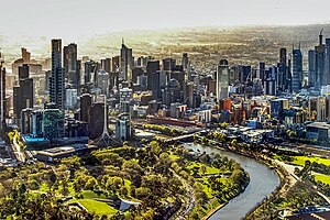
Melbourne ( MEL-bərn, locally [ˈmæɫbən] ; Boonwurrung/Woiwurrung: Narrm or Naarm) is the capital and most populous city of the Australian state of Victoria, and the second-most populous city in Australia, after Sydney. Its name generally refers to a 9,993 km2 (3,858 sq mi) metropolitan area also known as Greater Melbourne, comprising an urban agglomeration of 31 local municipalities, although the name is also used specifically for the local municipality of City of Melbourne based around its central business area. The metropolis occupies much of the northern and eastern coastlines of Port Phillip Bay and spreads into the Mornington Peninsula, part of West Gippsland, as well as the hinterlands towards the Yarra Valley, the Dandenong Ranges, and the Macedon Ranges.

Deva House
Distance: Approx. 112 meters
Latitude and longitude: -37.8142,144.96414
Deva House is a 1926 commercial building in Melbourne, Australia designed by Harry Norris, one of the most prolific architects in the city during the period from 1920 to 1930, and noted for his Art Deco buildings, incorporating both emerging Australian and American architectural styles.

Altson's Corner
Distance: Approx. 88 meters
Latitude and longitude: -37.81597,144.96423
Altson's Corner is a heritage listed Edwardian building located on the corner of Elizabeth Street and Collins St in CBD of Melbourne, Australia, built for tobacconist Richard Altson in 1904, and extended in 1914.
Yule House
Distance: Approx. 32 meters
Latitude and longitude: -37.815069,144.964324
Yule House is a five-story office building situated at 309-311 Little Collins Street, Melbourne, Australia. It was constructed in 1932 from a design by Melbourne-based architecture firm, Oakley & Parkes. Yule House was one of Melbourne’s first commercial buildings to exhibit the Streamline Moderne style (a branch of Art Deco) of architecture and began the style's rise in popularity throughout the 1930s.

260 Collins
Shopping mall in Melbourne, Australia
Distance: Approx. 111 meters
Latitude and longitude: -37.8159,144.9649
260 Collins (formerly St. Collins Lane) is a shopping centre completed in 2016, designed by ARM Architecture, which stretches between Collins and Little Collins streets in Melbourne, Australia. The centre runs under a budget hotel occupying the upper nine floors.
Weather in this IP's area
clear sky
12 Celsius
11 Celsius
10 Celsius
13 Celsius
1019 hPa
63 %
1019 hPa
1014 hPa
10000 meters
1.54 m/s
230 degree
06:05:58
20:01:51
