Country:
Region:
City:
Latitude and Longitude:
Time Zone:
Postal Code:
IP information under different IP Channel
ip-api
Country
Region
City
ASN
Time Zone
ISP
Blacklist
Proxy
Latitude
Longitude
Postal
Route
Luminati
Country
Region
sh
City
wedel
ASN
Time Zone
Europe/Berlin
ISP
TNG Stadtnetz GmbH
Latitude
Longitude
Postal
IPinfo
Country
Region
City
ASN
Time Zone
ISP
Blacklist
Proxy
Latitude
Longitude
Postal
Route
db-ip
Country
Region
City
ASN
Time Zone
ISP
Blacklist
Proxy
Latitude
Longitude
Postal
Route
ipdata
Country
Region
City
ASN
Time Zone
ISP
Blacklist
Proxy
Latitude
Longitude
Postal
Route
Popular places and events near this IP address

Rissen
Quarter of Hamburg in Germany
Distance: Approx. 3894 meters
Latitude and longitude: 53.57916667,9.75277778
Rissen () is a quarter of the city of Hamburg in Germany. It is located in the borough of Altona and is the westernmost quarter of Hamburg, bordering the German federal state of Schleswig-Holstein in the west, north, and northeast and the Elbe river to the south. In 2020, the population was 16,051.

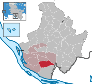
Wedel
Town in Schleswig-Holstein, Germany
Distance: Approx. 1144 meters
Latitude and longitude: 53.58333333,9.7
Wedel is a town in the district of Pinneberg, in Schleswig-Holstein, in northern Germany. It is situated on the right bank of the Elbe, approximately 20 kilometres (12 mi) south of Elmshorn, and 17 kilometres (11 mi) west of Hamburg.

Fachhochschule Wedel University of Applied Sciences
German non-profit university of applied sciences
Distance: Approx. 2576 meters
Latitude and longitude: 53.5784,9.7285
The Fachhochschule Wedel University of Applied Sciences gGmbH is one of the few private but non-profit universities of applied sciences in Germany. It is state-recognized and offers eleven twelve bachelor's and six eight master's degrees in the fields of computer science, technology and economics. It is located on the western outskirts of Hamburg in Schleswig-Holstein and is financed through tuition fees, a state grant and third-party funding.

Holm, Pinneberg
Municipality in Schleswig-Holstein, Germany
Distance: Approx. 3344 meters
Latitude and longitude: 53.61666667,9.66666667
Holm is a municipality in the district of Pinneberg, in Schleswig-Holstein, Germany. It is part of the Amt Geest und Marsch Südholstein. In the eastern part is the local recreation area Holmer Sandberge, to the west of Holm begins the Elbmarsch.
Wittmoor Measurement and Reception Station
Distance: Approx. 4085 meters
Latitude and longitude: 53.62722222,9.72388889
The Wittmoor Measurement and Reception Station in Holm, Pinneberg district, northern Germany, is an equipment of the Norddeutscher Rundfunk (North German broadcasting company) for the supervision of the broadcasting frequencies in the southern Pinneberg district and the western area of Hamburg. Also, it accommodates a big archive of sound carriers which is accommodated in several buildings and serves for the broadcast of the radio program of N-Joy on 95.6 MHz with 200 W ERP. The reception aerials and broadcasting aerials of the station are on a 118-metre (387 ft) high, guyed lattice steel mast with a square cross-section which replaced an older 80-metre (260 ft) high guyed lattice steel mast which was dismantled, after the erection of the new mast. Also, there is a dish aerial on the station area for satellite reception with approx.

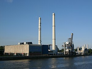
Wedel Power Station
Distance: Approx. 3462 meters
Latitude and longitude: 53.56666667,9.72527778
Wedel Power Station is a coal-fired power station in Wedel, Germany. Its two 151 metres tall chimneys were built by HEW between 1961 and 1965. It consists of 2 units with an output power of 200 MW. The station is fronted by a 320-meter quay.

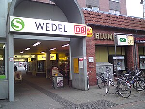
Wedel station
Railway station in Wedel, Germany
Distance: Approx. 1384 meters
Latitude and longitude: 53.58166667,9.705
Wedel station (officially Wedel (Holst), meaning Wedel in Holstein) is a railway station on the Altona-Blankenese line, served by the rapid transit trains of the Hamburg S-Bahn, located in Wedel, Germany. It is a terminus of the line S1.

Wedeler Au
River in Germany
Distance: Approx. 2687 meters
Latitude and longitude: 53.5761,9.6711
Wedeler Au (German pronunciation: [ˈveːdəlɐ ˈaʊ̯] ; in older texts also named Wedelbe(c)k) is a river of Hamburg and Schleswig-Holstein, Germany. It flows into the Elbe near Wedel.

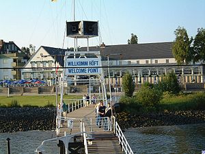
Willkomm-Höft
Distance: Approx. 2852 meters
Latitude and longitude: 53.56805556,9.7025
The Schiffsbegrüßungsanlage Willkomm-Höft (literally, Ship Greeting Station Welcome Point, Höft being Low German for headland or point) is a facility at the Schulauer Fährhaus (Schulau Ferry Building, a restaurant) in Schulau, the southern district of Wedel on the Lower Elbe. It was founded by Otto Friedrich Behnke on 12 June 1952. Currently, it is sponsored by Nautische Kameradschaft HANSEA. Ships heading upriver for or downriver from the port of Hamburg are welcomed or bid farewell by dipping the Hamburg flag and by hoisting the international flag signal for "bon voyage" (letters U and W).

Klövensteen
Forest in Hamburg and Schleswig-Holstein, Germany
Distance: Approx. 3134 meters
Latitude and longitude: 53.5964,9.7463
The Klövensteen is a woodland area west of Hamburg, Germany. The forest covers an area of more than 513 ha (1,270 acres). The Klövensteen is located in the districts of Hamburg in Rissen and Sülldorf and also has parts in Schleswig-Holstein namely in the towns of Pinneberg and Wedel and in the communities of Appen and Holm.

Schnaakenmoor
Distance: Approx. 4141 meters
Latitude and longitude: 53.6008,9.7606
The Schnaakenmoor is a nature reserve area located in the northwest of the forest district Klövensteen in Hamburg, Germany. The Klövensteen is a forest district and a recreational area in the west of Hamburg. Schnaakenmoor covers also some areas from the Grotenmoor, the Spitzendorfer Moorflagen, Babenbischenweg and Feldweg 83.

Rissen station
Railway station in Hamburg, Germany
Distance: Approx. 4016 meters
Latitude and longitude: 53.5832,9.7573
Rissen railway station in Hamburg, Germany, is located on the extended Altona-Blankenese line and is served by the trains of the Hamburg S-Bahn. The rapid transit trains of the line S1 of the Hamburg S-Bahn call the station in the Rissen quarter of the Hamburg borough of Altona.
Weather in this IP's area
moderate rain
5 Celsius
0 Celsius
4 Celsius
5 Celsius
1003 hPa
94 %
1003 hPa
1002 hPa
10000 meters
6.17 m/s
240 degree
100 %
07:51:36
16:21:08