Country:
Region:
City:
Latitude and Longitude:
Time Zone:
Postal Code:
IP information under different IP Channel
ip-api
Country
Region
City
ASN
Time Zone
ISP
Blacklist
Proxy
Latitude
Longitude
Postal
Route
Luminati
Country
ASN
Time Zone
Europe/Skopje
ISP
Drustvo za telekomunikaciski uslugi TELEKABEL DOOEL Stip
Latitude
Longitude
Postal
IPinfo
Country
Region
City
ASN
Time Zone
ISP
Blacklist
Proxy
Latitude
Longitude
Postal
Route
db-ip
Country
Region
City
ASN
Time Zone
ISP
Blacklist
Proxy
Latitude
Longitude
Postal
Route
ipdata
Country
Region
City
ASN
Time Zone
ISP
Blacklist
Proxy
Latitude
Longitude
Postal
Route
Popular places and events near this IP address

Bitola
City in Pelagonia, North Macedonia
Distance: Approx. 61 meters
Latitude and longitude: 41.03194444,21.33472222
Bitola (; Macedonian: Битола [ˈbitɔɫa] ) is a city in the southwestern part of North Macedonia. It is located in the southern part of the Pelagonia valley, surrounded by the Baba, Nidže, and Kajmakčalan mountain ranges, 14 kilometres (9 miles) north of the Medžitlija-Níki border crossing with Greece. The city stands at an important junction connecting the south of the Adriatic Sea region with the Aegean Sea and Central Europe, and it is an administrative, cultural, industrial, commercial, and educational centre.

Battle of Monastir
Battle during the First Balkan War
Distance: Approx. 495 meters
Latitude and longitude: 41.032799,21.34029
The Battle of Monastir took place near the town of Bitola, Macedonia (then known as Monastir) during the First Balkan War, between Serbian and Ottoman forces from 16 to 19 November 1912. It resulted in a Serbian victory after heavy fighting north of the city, the routed Turks fled abandoning their guns.

Bitola Municipality
Municipality of North Macedonia
Distance: Approx. 244 meters
Latitude and longitude: 41.03333333,21.33333333
Bitola (Macedonian: Битола [ˈbitɔɫa] ) is a municipality in the southern part of North Macedonia. Bitola is also the name of the city where the municipal seat is located. The municipality is located in the Pelagonia Statistical Region.
New Mosque, Bitola
Former mosque in Bitola, North Macedonia
Distance: Approx. 68 meters
Latitude and longitude: 41.03083333,21.335
The Yeni Mosque (Macedonian: Јени џамија, romanized: Jeni džamija, Albanian: Jeni Xhamia, Turkish: Yeni Cami) situated in Bitola, North Macedonia, was built in 1558 by Kadi Mahmud-efendi. It is well known for its exquisite decorative ornaments and stalactites. The glazed decorative features found on the Yeni Mosque are the only examples of their kind in the country.
Battle of Bitola (1015)
1015 battle of the Byzantine-Bulgarian Wars
Distance: Approx. 61 meters
Latitude and longitude: 41.03194444,21.33472222
The battle of Bitola (Bulgarian: Битка при Битоля) took place near the town of Bitola, in Bulgarian territory, between a Bulgarian army under the command of the voivode Ivats and a Byzantine army led by the strategos George Gonitsiates. It was one of the last open battles between the First Bulgarian Empire and the Byzantine Empire. The Bulgarians were victorious and the Byzantine Emperor Basil II had to retreat from the Bulgarian capital Ohrid, whose outer walls were by that time already breached by the Bulgarians.

Magnolia Square
Distance: Approx. 148 meters
Latitude and longitude: 41.0301029,21.3350791
Magnolia Square (Macedonian: Плоштад Магнолија, romanized: Ploštad Magnolija) is a public space and a town square of the City of Bitola, located near the Clock Tower. Around the square are old houses from the Macedonian and Ottoman architecture that are purchased from various companies, firms and coffee bars. Bitola, which was a major cultural center in the Ottoman Empire has very interesting buildings from the Turks from which many on Main Street and Magnolia Square.

Clock Tower (Bitola)
Distance: Approx. 93 meters
Latitude and longitude: 41.03083333,21.33388889
The Clock Tower of Bitola, known as Saat Kula (Macedonian: Саат кула), is a clock tower and one of the landmarks of the Macedonian city of Bitola. The clock tower in Bitola is a very practical monument aiding people with the time of day. The original clock tower was first built in 1664 by Mahmut Bey when the city was part of the Ottoman Empire and known as Manastır.

Gazi Hajdar Kadi Mosque
Mosque in Bitol, North Macedonia
Distance: Approx. 510 meters
Latitude and longitude: 41.03499167,21.338475
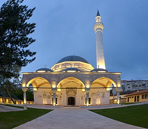
The Gazi Hajdar Kadi Mosque, (Macedonian: Ајдар Кади Џамија, Ajdar Kadi Džamija; Albanian: Xhamia e Gazi Hajdar Kadiut, Turkish: Gazi Haydar Kadi Cami) is a mosque, situated in Bitola, North Macedonia. In the past the religious building has been transformed into a warehouse by the local Macedonian authorities. A thorough reconstruction was undergoing for several years with the assistance and cooperation of the Turkish Republic, and finally it was fully put into service and opened to public in November 2016.

Co-Cathedral of the Sacred Heart, Bitola
Church in Bitola, North Macedonia
Distance: Approx. 309 meters
Latitude and longitude: 41.02879,21.33594
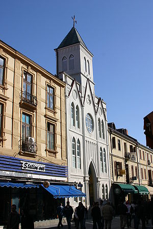
The Co-Cathedral of the Sacred Heart (Macedonian: Црква Пресвето Срце Исусово) is the name given to a religious building of the Catholic church that is located in the city of Bitola in North Macedonia and is the co-cathedral of the Diocese of Skopje. The establishment of the church dates back to the nineteenth century, by the Vincentians, who set out to spread the Catholic faith among the Orthodox population of the Ottoman Empire. The founder of the Church was Juan Jose Lepavek, who in 1857 bought a hotel from which to develop a future church, which was completed in 1870, but destroyed by fire in 1900.
Zandan Tower
Distance: Approx. 798 meters
Latitude and longitude: 41.02781,21.32648
Zandan Tower (Macedonian: Зандан куле) is a former Ottoman defensive and prison tower in Bitola, North Macedonia. It was built in the early 17th century by Haci Mahmud Efendi, the mufti of Bitola, on a private homestead next to a multi-family housing block in which Turkish and Albanian residents lived. It is accessed via a staircase leading up to the double door made of thick oak wood on the tower's south façade.

Church of the Nativity of the Virgin Mary, Bitola
Distance: Approx. 373 meters
Latitude and longitude: 41.030278,21.338889
The Church of the Nativity of the Virgin Mary (Macedonian: Црква „Св. Богородица“) is a Macedonian Orthodox church of the Prespa-Pelagona Diocese in Bitola, North Macedonia. The church was built in 1870 and consecrated in 1876 by the Bulgarian Exarchist community and has icons dating from the 19th century.

Church of Saint Demetrius, Bitola
Distance: Approx. 199 meters
Latitude and longitude: 41.029722,21.333889
The Church of Saint Demetrius (Macedonian: Црква „Св. Димитриј“) is the main Macedonian Orthodox church of Bitola, North Macedonia, part of the Prespa-Pelagonia Diocese. It was built in 1830 and its most remarkable feature is considered to be its wood-carved iconostasis.
Weather in this IP's area
light rain
8 Celsius
8 Celsius
8 Celsius
8 Celsius
1020 hPa
96 %
1020 hPa
947 hPa
3198 meters
1.17 m/s
1.76 m/s
118 degree
100 %
06:21:24
16:17:05

