Country:
 Croatia
Region:
City:
Latitude and Longitude:
Time Zone:
Postal Code:
IP information under different IP Channel
ip-api
Country
Region
City
ASN
Time Zone
ISP
Blacklist
Proxy
Latitude
Longitude
Postal
Route
IPinfo
Country
Region
City
ASN
Time Zone
ISP
Blacklist
Proxy
Latitude
Longitude
Postal
Route
MaxMind
Country
Region
City
ASN
Time Zone
ISP
Blacklist
Proxy
Latitude
Longitude
Postal
Route
Luminati
Country
HRRegion
14
City
nasice
ASN
Time Zone
Europe/Zagreb
ISP
Telemach Hrvatska d.o.o.
Latitude
Longitude
Postal
db-ip
Country
Region
City
ASN
Time Zone
ISP
Blacklist
Proxy
Latitude
Longitude
Postal
Route
ipdata
Country
Region
City
ASN
Time Zone
ISP
Blacklist
Proxy
Latitude
Longitude
Postal
Route
Popular places and events near this IP address
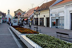
Đakovo
Town in Osijek-Baranja, Croatia
Distance: Approx. 7748 meters
Latitude and longitude: 45.31,18.41
Đakovo (Croatian pronunciation: [ˈdʑakɔʋɔ]; Hungarian: Diakovár, German: Diakowar, Serbian Cyrillic: Ђаково) is a town in the region of Slavonia, Croatia. Đakovo is the centre of the fertile and rich Đakovo region (Croatian: Đakovština [d͡ʑakǒːʋʃtina]).
Drenje, Osijek-Baranja County
Municipality in Osijek-Baranja, Croatia
Distance: Approx. 5138 meters
Latitude and longitude: 45.38,18.28
Drenje (Hungarian: Drenye, Serbian Cyrillic: Дрење) is a municipality in Osijek-Baranja County, Croatia. In the 2021 census, there were a total of 2,700 inhabitants, in the following settlements: Borovik, population 6 Bračevci, population 209 Bučje Gorjansko, population 73 Drenje, population 583 Kućanci Đakovački, population 148 Mandićevac, population 284 Paljevina, population 183 Podgorje Bračevačko, population 70 Potnjani, population 497 Preslatinci, population 160 Pridvorje, population 198 Slatinik Drenjski, population 289 In the same census, 95.7% of the population were Croats.
Gorjani, Croatia
Municipality in Osijek-Baranja, Croatia
Distance: Approx. 6772 meters
Latitude and longitude: 45.4,18.37
Gorjani (Hungarian: Gara; German: Gerendau, Görrach) is a village and a municipality in Osijek-Baranja County, Croatia. In the 2011 census, there were a total of 1,550 inhabitants, in the following settlements: Gorjani, population 1,008 Tomašanci, population 583 In the same census, 97% were Croats. Gorjani village was the seat of the House of Garai (Garay), a Hungarian-Croatian noble family, and a branch of the Dorozsma (Durusma) clan.
Satnica Đakovačka
Municipality in Osijek-Baranja, Croatia
Distance: Approx. 4144 meters
Latitude and longitude: 45.3558,18.3781
Satnica Đakovačka (Hungarian: Szatnica) is a village and a municipality in Osijek-Baranja County, in eastern Croatia. In the 2011 census, there were a total of 2,123 inhabitants, in the following settlements: Gašinci, population 691 Satnica Đakovačka, population 1,432 In the same census, 99% of the population were Croats.

Roman Catholic Archdiocese of Đakovo–Osijek
Roman Catholic archdiocese in Croatia
Distance: Approx. 7748 meters
Latitude and longitude: 45.31,18.41
The Archdiocese of Đakovo–Osijek (Croatian: Đakovačko-osječka nadbiskupija; Latin: Archidioecesis Diacovensis–Osijekensis) is a Latin archdiocese of the Catholic Church in Croatia. The archdiocese is centred on the city of Đakovo, in Croatia. Đuro Hranić was appointed Archbishop on 18 April 2013 by Pope Francis following the resignation of Marin Srakić.
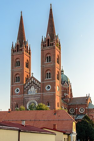
Đakovo Cathedral
Church in Croatia
Distance: Approx. 7973 meters
Latitude and longitude: 45.3075,18.4111
The Đakovo Cathedral or Cathedral basilica of St. Peter (Croatian: Katedrala bazilika Svetog Petra) is the cathedral of the Roman Catholic Archdiocese of Đakovo-Osijek in Đakovo, Croatia. Đakovo Cathedral is the biggest sacral newly built building of Croatian historicism.
Selci Đakovački
Village in Croatia
Distance: Approx. 3884 meters
Latitude and longitude: 45.31666667,18.35
Selci Đakovački is a village in Croatia. It is connected by the D38 highway. The local sport clubs include the football club NK Omladinac.
Potnjani
Village in Croatia
Distance: Approx. 5906 meters
Latitude and longitude: 45.4,18.31666667
Potnjani is a village in Croatia. It is connected by the D515 highway.

Đakovo internment camp
Internment camp run by the Ustaše in Croatia during World War II
Distance: Approx. 7842 meters
Latitude and longitude: 45.318063,18.417604
Đakovo was an internment camp for Jewish, and to a lesser extent Serb, women and children in the town of Đakovo in the Independent State of Croatia (NDH) that was operational between December 1941 and July 1942, during World War II. The camp was established on the site of an abandoned flour mill that was once used by the Roman Catholic Archdiocese of Đakovo-Osijek and was initially run autonomously by the Jewish community. It received its first arrivals on 2 December 1941. In early 1942, the camp experienced an outbreak of typhoid fever which was exacerbated by the arrival of Jewish deportees from Slovenia.
Tomašanci
Place
Distance: Approx. 8156 meters
Latitude and longitude: 45.38583333,18.41527778
Tomašanci is a village near Gorjani, Croatia. In the 2011 census, it had 583 inhabitants.
Gašinci
Place
Distance: Approx. 1927 meters
Latitude and longitude: 45.33388889,18.31111111
Gašinci is a village near Satnica Đakovačka, Croatia. In the 2011 census, it had 691 inhabitants.
Mandićevac
Village in Osijek-Baranja County, Croatia
Distance: Approx. 6580 meters
Latitude and longitude: 45.36972222,18.24861111
Mandićevac is a village near Drenje, Osijek-Baranja County, Croatia. In the 2011 census, it had 284 inhabitants.
Weather in this IP's area
light rain
16 Celsius
16 Celsius
16 Celsius
17 Celsius
1018 hPa
82 %
1018 hPa
1005 hPa
10000 meters
0.89 m/s
1.34 m/s
293 degree
93 %
06:31:32
18:48:39