Country:
 Croatia
Region:
City:
Latitude and Longitude:
Time Zone:
Postal Code:
IP information under different IP Channel
ip-api
Country
Region
City
ASN
Time Zone
ISP
Blacklist
Proxy
Latitude
Longitude
Postal
Route
IPinfo
Country
Region
City
ASN
Time Zone
ISP
Blacklist
Proxy
Latitude
Longitude
Postal
Route
MaxMind
Country
Region
City
ASN
Time Zone
ISP
Blacklist
Proxy
Latitude
Longitude
Postal
Route
Luminati
Country
HRRegion
13
City
zadar
ASN
Time Zone
Europe/Zagreb
ISP
Telemach Hrvatska d.o.o.
Latitude
Longitude
Postal
db-ip
Country
Region
City
ASN
Time Zone
ISP
Blacklist
Proxy
Latitude
Longitude
Postal
Route
ipdata
Country
Region
City
ASN
Time Zone
ISP
Blacklist
Proxy
Latitude
Longitude
Postal
Route
Popular places and events near this IP address
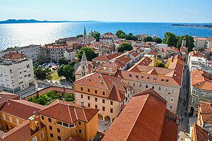
Zadar
City in Zadar County, Croatia
Distance: Approx. 830 meters
Latitude and longitude: 44.11944444,15.23194444
Zadar (US: ZAH-dar, Croatian: [zâdar] ; Italian: Zara [ˈdzaːra]; see also other names) is the oldest continuously inhabited city in Croatia. It is situated on the Adriatic Sea, at the northwestern part of Ravni Kotari region. Zadar serves as the seat of Zadar County and of the wider northern Dalmatian region.
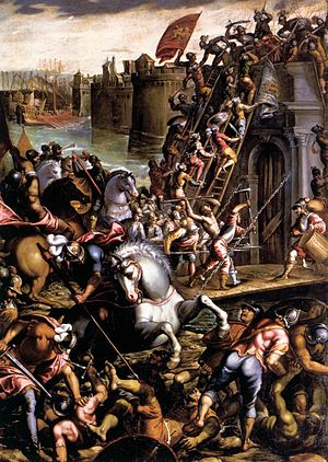
Siege of Zara
Part of the Fourth Crusade
Distance: Approx. 1330 meters
Latitude and longitude: 44.11416667,15.22777778
The siege of Zara or siege of Zadar (Croatian: opsada Zadra; Hungarian: Zára ostroma; 10–24 November 1202) was the first major action of the Fourth Crusade and the first attack against a Catholic city by Catholic crusaders. The crusaders had an agreement with Venice for transport across the sea, but the price far exceeded what they were able to pay. Venice set the condition that the crusaders help them capture Zadar (or Zara), a constant battleground between Venice on one side and Croatia and Hungary on the other, whose king, Emeric, pledged himself to join the Crusade.
1991 riot in Zadar
1991 riot in Croatia against the Yugoslav government
Distance: Approx. 675 meters
Latitude and longitude: 44.116677,15.235236
The 1991 riot in Zadar was an act of violence that took place in the Croatian city of Zadar on 2 May 1991. Following an incident in the Zadar hinterland in which a Croatian policeman was killed, reportedly by SAO Krajina militiamen, Croatian civilians vandalized, destroyed and looted properties belonging to ethnic Serbs and Yugoslav companies in the city.

Roman Catholic Archdiocese of Zadar
Catholic archdiocese in Croatia
Distance: Approx. 1494 meters
Latitude and longitude: 44.1159,15.2245
The Archdiocese of Zadar (Latin: Archidioecesis Iadrensis; Croatian: Zadarska nadbiskupija) is a Latin Church ecclesiastical territory or archdiocese of the Catholic church in Croatia. The diocese was established in the 3rd century AD and was made an archdiocese by the Pope Anastasius IV in 1154. Today, it is not part of any ecclesiastical province of Croatia, rather it is the only Croatian archdiocese directly subject to the Holy See.

Zadar Cathedral
Church in Zadar, Croatia
Distance: Approx. 1487 meters
Latitude and longitude: 44.11625,15.22444444
The Cathedral of St. Anastasia (Croatian: Katedrala sv. Stošije) is the Roman Catholic cathedral of Zadar, Croatia, seat of the Archdiocese of Zadar, and the largest church in all of Dalmatia (the coastal region of Croatia).
Battle of Zadar
Battle of the Croatian War of Independence
Distance: Approx. 983 meters
Latitude and longitude: 44.12,15.23
The Battle of Zadar (Croatian: Bitka za Zadar) was a military engagement between the Yugoslav People's Army (Jugoslovenska Narodna Armija, or JNA), supported by the Croatian Serb Serbian Autonomous Oblast of Krajina (SAO Krajina), and the Croatian National Guard (Zbor Narodne Garde, or ZNG), supported by the Croatian Police. The battle was fought north and east of the city of Zadar, Croatia, in the second half of September and early October 1991 during the Croatian War of Independence. Although the JNA's initial orders were to lift the Croatian siege of the JNA's barracks in the city and isolate the region of Dalmatia from the rest of Croatia, the orders were amended during the battle to include capturing the Port of Zadar in the city centre.
Stadion Stanovi
Football stadium in Zadar, Croatia
Distance: Approx. 893 meters
Latitude and longitude: 44.112667,15.246829
Stadion Stanovi (English: Stanovi Stadium) is a football stadium in Zadar, Croatia. It serves as the home ground for football club HNK Zadar. The stadium has a capacity of 5,860, of which 2,860 are seated.
Jazine Basketball Hall
Indoor arena in Croatia
Distance: Approx. 1260 meters
Latitude and longitude: 44.11083333,15.23305556
Jazine Basketball Hall (Croatian: Dvorana Jazine) is an indoor sports arena located in Jazine, Zadar, Croatia. The official seating capacity of the arena is 3,500 people. It was opened in 1968 after a construction period of 70 days.

Krešimir Ćosić Hall
Sports arena in Zadar, Croatia
Distance: Approx. 269 meters
Latitude and longitude: 44.1195,15.24558889
The Krešimir Ćosić Hall (Croatian: Dvorana Krešimir Ćosić) is a multi-purpose indoor sports arena located in Zadar, Croatia. The arena is home to the KK Zadar basketball club and also hosts concerts, conventions and other sporting, business and entertainment events. From October 2008, its official name became Krešimir Ćosić Hall, named after the legendary Croatian basketball player Krešimir Ćosić.

Chest of Saint Simeon
Distance: Approx. 1324 meters
Latitude and longitude: 44.11338889,15.22852778
The Chest of Saint Simeon or Saint Simeon's Casket (Croatian: Škrinja sv. Šimuna) is a rectangular cedarwood sarcophagus in the shape of a chasse, overlaid with silver and silver-gilt plaques, said to hold the relics of St Simon the God-receiver; it is located over the main altar in the Church of Saint Simeon in Zadar, Croatia. The chest, considered a masterpiece of medieval art and also a unique monument of the goldsmith's craft of the age, is one of the most interesting works in gold in Europe now under the protection of UNESCO. It was made by local goldsmiths to an Italian design between 1377 and 1380.

Church of Saint Chrysogonus, Zadar
Church in Zadar, Croatia
Distance: Approx. 1343 meters
Latitude and longitude: 44.1161,15.2264
The Church of St. Chrysogonus (Croatian: Crkva sv. Krševana) is a Roman Catholic church located in Zadar, Croatia, named after Saint Chrysogonus, the patron saint of the city.

St. Mary's Church, Zadar
Distance: Approx. 1497 meters
Latitude and longitude: 44.1152,15.2248
Church of St. Mary is a Benedictine monastery located in Zadar, Croatia. It was founded in 1066 on the eastern side of the town's old Roman forum.
Weather in this IP's area
scattered clouds
18 Celsius
18 Celsius
18 Celsius
18 Celsius
1015 hPa
68 %
1015 hPa
1013 hPa
10000 meters
2.06 m/s
120 degree
40 %
06:44:08
19:00:43