95.172.69.76 - IP Lookup: Free IP Address Lookup, Postal Code Lookup, IP Location Lookup, IP ASN, Public IP
Country:
Region:
City:
Location:
Time Zone:
Postal Code:
IP information under different IP Channel
ip-api
Country
Region
City
ASN
Time Zone
ISP
Blacklist
Proxy
Latitude
Longitude
Postal
Route
Luminati
Country
ASN
Time Zone
Europe/London
ISP
Packetfabric (uk) Ltd
Latitude
Longitude
Postal
IPinfo
Country
Region
City
ASN
Time Zone
ISP
Blacklist
Proxy
Latitude
Longitude
Postal
Route
IP2Location
95.172.69.76Country
Region
bayern
City
ludwigsvorstadt
Time Zone
Europe/Berlin
ISP
Language
User-Agent
Latitude
Longitude
Postal
db-ip
Country
Region
City
ASN
Time Zone
ISP
Blacklist
Proxy
Latitude
Longitude
Postal
Route
ipdata
Country
Region
City
ASN
Time Zone
ISP
Blacklist
Proxy
Latitude
Longitude
Postal
Route
Popular places and events near this IP address

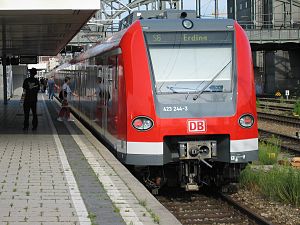
Munich S-Bahn
Electric rail transit system in Germany
Distance: Approx. 548 meters
Latitude and longitude: 48.1408,11.555
The Munich S-Bahn (German: S-Bahn München) is an electric rail transit system in Munich, Germany. "S-Bahn" is the German abbreviation for Stadtschnellbahn (literally, "urban rapid rail"), and the Munich S-Bahn exhibits characteristics of both rapid transit and commuter rail systems. The Munich S-Bahn network is operated by S-Bahn München, a subsidiary of DB Regio Bayern, which is itself a subsidiary of the German national railway company, Deutsche Bahn.

1960 Munich C-131 crash
1960 aviation disaster in Munich, West Germany
Distance: Approx. 555 meters
Latitude and longitude: 48.13888889,11.54972222
On 17 December 1960, a Convair C-131D Samaritan operated by the United States Air Force on a flight from Munich to RAF Northolt crashed shortly after take-off from Munich-Riem Airport, due to fuel contamination. All 20 passengers and crew on board as well as 32 people on the ground were killed.

Theresienwiese
Official ground of the Munich Oktoberfest
Distance: Approx. 511 meters
Latitude and longitude: 48.13333333,11.55
Theresienwiese is an open space in the Munich borough of Ludwigsvorstadt-Isarvorstadt. It serves as the official ground of the Munich Oktoberfest. A space of 420,000 square metres (4,500,000 sq ft), it is bordered in the west by the Ruhmeshalle and the Bavaria statue, symbolizing the State of Bavaria, and in the east by Esperantoplatz, a square named for the international language Esperanto.

München Hauptbahnhof
Main railway station in Munich, Germany
Distance: Approx. 552 meters
Latitude and longitude: 48.14083333,11.555
München Hauptbahnhof or Munich Central Station is the main railway station in the city of Munich, Germany. It is one of the three stations with long-distance services in Munich, the others being Munich East station (München Ost) and Munich-Pasing station (München-Pasing). München Hauptbahnhof sees about 450,000 passengers a day, which puts it on par with other large stations in Germany, such as Hamburg Hauptbahnhof and Frankfurt (Main) Hauptbahnhof.

Theresienwiese station
Station of the Munich U-Bahn
Distance: Approx. 184 meters
Latitude and longitude: 48.13638889,11.55333333
Theresienwiese is a station of Munich U-Bahn on the U4 and U5 line. It is the closest station to the Oktoberfest grounds on the Theresienwiese. During Oktoberfest, the station handles 21,000 passengers per hour each direction.

Geisel Privathotels
Distance: Approx. 645 meters
Latitude and longitude: 48.13972222,11.56222222
Geisel Privathotels is a privately owned hospitality group founded in 1900 operating three hotels and a restaurant in Munich, Germany.

Deutsches Theater (Munich)
Distance: Approx. 518 meters
Latitude and longitude: 48.13694444,11.5625
Deutsches Theater München ("German Theatre") is a theatre in Munich, Bavaria, Germany. It is Germany's largest theater for guest performances. In the theater especially musicals are staged.

Oktoberfest bombing
1980 neo-Nazi terrorist attack in Munich, West Germany
Distance: Approx. 443 meters
Latitude and longitude: 48.13592,11.549736
The Oktoberfest bombing (German: Oktoberfest-Attentat) was a far-right terrorist attack. On 26 September 1980, 13 people were killed (including the perpetrator) and more than 200 injured by the explosion of an improvised explosive device (IED) at the main entrance of the Oktoberfest festival in Munich, West Germany. The bombing was attributed to the right-wing extremist and geology student Gundolf Köhler, who was instantly killed in the attack as the bomb exploded prematurely.

St. Paul's Church, Munich
Catholic church in Munich, Germany
Distance: Approx. 264 meters
Latitude and longitude: 48.13638889,11.55222222
St. Paul's Church (German: St Paul or Paulskirche) is a large Catholic church in the Ludwigsvorstadt-Isarvorstadt quarter of Munich, Bavaria, Germany. It was built in 1892–1906, designed by the Austrian architect Georg von Hauberrisser in the Gothic Revival style, north of the Theresienwiese.

LMU Klinikum
Hospital in Bavaria, Germany
Distance: Approx. 595 meters
Latitude and longitude: 48.132478,11.561845
The LMU Klinikum (until 2020 Klinikum der Universität München) is the merged hospital complex of the Ludwig Maximilian University of Munich (LMU), including the Campus Innenstadt in the city center and the Campus Großhadern in Hadern. The hospital houses more than 2000 beds with 48 clinics, institutes and departments, making it one of the largest hospitals in Europe. In 2015, the Ludwig Maximilian University was ranked the leading German university in the subject area "Clinical, pre-clinical and health" according to the Times Higher Education World University Ranking.

Arnulfstraße
Street in Munich, Germany
Distance: Approx. 681 meters
Latitude and longitude: 48.1419,11.5575
The Arnulfstraße is a 3.8 km long urban street in Munich. It leads from the Bahnhofplatz in the Ludwigsvorstadt through the Maxvorstadt (north of the railway) west to Romanplatz in Neuhausen. Over the Hackerbrücke, there is a connection to the Landsberger Straße, which runs parallel to the south of the railway tracks.

Forum Queeres Archiv München
Distance: Approx. 338 meters
Latitude and longitude: 48.1383325,11.5529736
The Forum Queeres Archiv München (English: Forum Queer Archive Munich - LGBTIQ* in History and Culture) in Munich, Germany, is an association and archive with collections focusing on LGBTQ+ history and culture in Munich, Bavaria and Germany. It opened in 1999 and was named forum homosexualität münchen – Lesben und Schwule in Geschichte und Kultur e.V. till 2019.
Weather in this IP's area
broken clouds
-5 Celsius
-5 Celsius
-6 Celsius
-4 Celsius
1042 hPa
90 %
1042 hPa
973 hPa
10000 meters
0.89 m/s
1.79 m/s
68 degree
71 %