95.160.78.45 - IP Lookup: Free IP Address Lookup, Postal Code Lookup, IP Location Lookup, IP ASN, Public IP
Country:
 Poland
Region:
City:
Location:
Time Zone:
Postal Code:
ISP:
ASN:
language:
User-Agent:
Proxy IP:
Blacklist:
IP information under different IP Channel
ip-api
Country
Region
City
ASN
Time Zone
ISP
Blacklist
Proxy
Latitude
Longitude
Postal
Route
db-ip
Country
Region
City
ASN
Time Zone
ISP
Blacklist
Proxy
Latitude
Longitude
Postal
Route
IPinfo
Country
Region
City
ASN
Time Zone
ISP
Blacklist
Proxy
Latitude
Longitude
Postal
Route
IP2Location
95.160.78.45Country
plRegion
mazowieckie
City
wolomin
Time Zone
Europe/Warsaw
ISP
Language
User-Agent
Latitude
Longitude
Postal
ipdata
Country
Region
City
ASN
Time Zone
ISP
Blacklist
Proxy
Latitude
Longitude
Postal
Route
Popular places and events near this IP address

Wołomin
Place in Masovian Voivodeship, Poland
Distance: Approx. 1253 meters
Latitude and longitude: 52.35,21.23333333
Wołomin [vɔˈwɔmin] is a town in the Warsaw metropolitan area in the Masovian Voivodship, seat of Wołomin County. Wołomin is situated approximately 20 km (12 mi) east of Warsaw, the capital of Poland, near the railway to Białystok. It has approximately 43,000 inhabitants and covers an area of 14 km2 (5 sq mi).
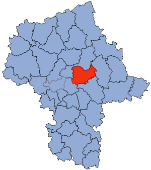
Wołomin County
County in Masovian Voivodeship, Poland
Distance: Approx. 1253 meters
Latitude and longitude: 52.35,21.23333333
Wołomin County (Polish: powiat wołomiński) is a territorial and administrative division in Masovian Voivodeship, east-central Poland. It came into being on January 1, 1999, as a result of the Polish local government reforms passed in 1998. The administrative seat of the county and also its largest town is Wołomin, which lies 22 kilometres (14 mi) north-east of Warsaw.

Kobyłka
Place in Masovian Voivodeship, Poland
Distance: Approx. 2961 meters
Latitude and longitude: 52.33333333,21.2
Kobyłka [kɔˈbɨu̯ka] is a town of almost 22,000 inhabitants in Poland within the Warsaw metropolitan area, located right outside of the Warsaw, near Wołomin in the Wołomin County in the Masovian Voivodeship.

Gmina Wołomin
Gmina in Masovian Voivodeship, Poland
Distance: Approx. 1253 meters
Latitude and longitude: 52.35,21.23333333
Gmina Wołomin is an urban-rural gmina (administrative district) in Wołomin County, Masovian Voivodeship, in east-central Poland. Its seat is the town of Wołomin, which lies approximately 22 kilometres (14 mi) north-east of Warsaw. The gmina covers an area of 59.52 square kilometres (23.0 sq mi), and as of 2006 its total population is 49,509 (out of which the population of Wołomin amounts to 36,711, and the population of the rural part of the gmina is 12,798).
Cięciwa, Wołomin County
Village in Masovian Voivodeship, Poland
Distance: Approx. 3831 meters
Latitude and longitude: 52.31666667,21.28333333
Cięciwa [t͡ɕɛnˈt͡ɕiva] is a village in the administrative district of Gmina Wołomin, within Wołomin County, Masovian Voivodeship, in east-central Poland. It lies approximately 6 kilometres (4 mi) south-east of Wołomin and 23 km (14 mi) north-east of Warsaw.
Czarna, Wołomin County
Village in Masovian Voivodeship, Poland
Distance: Approx. 3426 meters
Latitude and longitude: 52.36916667,21.22555556
Czarna [ˈt͡ʂarna] is a village in the administrative district of Gmina Wołomin, within Wołomin County, Masovian Voivodeship, in east-central Poland.
Leśniakowizna
Village in Masovian Voivodeship, Poland
Distance: Approx. 3226 meters
Latitude and longitude: 52.31666667,21.27
Leśniakowizna [lɛɕɲakɔˈvizna] is a village in the administrative district of Gmina Wołomin, within Wołomin County, Masovian Voivodeship, in east-central Poland.
Nowe Lipiny
Village in Masovian Voivodeship, Poland
Distance: Approx. 2847 meters
Latitude and longitude: 52.3575,21.27277778
Nowe Lipiny [ˈnɔvɛ liˈpinɨ] is a village in the administrative district of Gmina Wołomin, within Wołomin County, Masovian Voivodeship, in east-central Poland.
Stare Lipiny
Village in Masovian Voivodeship, Poland
Distance: Approx. 1715 meters
Latitude and longitude: 52.34138889,21.26722222
Stare Lipiny [ˈstarɛ liˈpinɨ] is a village in the administrative district of Gmina Wołomin, within Wołomin County, Masovian Voivodeship, in east-central Poland.
Stare Lipiny B
Village in Masovian Voivodeship, Poland
Distance: Approx. 1895 meters
Latitude and longitude: 52.34583333,21.26833333
Stare Lipiny B is a village in the administrative district of Gmina Wołomin, within Wołomin County, Masovian Voivodeship, in east-central Poland. It lies approximately 3 kilometres (2 mi) east of Wołomin and 24 km (15 mi) north-east of Warsaw.
Zagościniec
Village in Masovian Voivodeship, Poland
Distance: Approx. 3006 meters
Latitude and longitude: 52.36666667,21.25
Zagościniec [zaɡɔɕˈt͡ɕiɲɛt͡s] is a village in the administrative district of Gmina Wołomin, within Wołomin County, Masovian Voivodeship, in east-central Poland. It lies approximately 3 kilometres (2 mi) north-east of Wołomin and 24 km (15 mi) north-east of Warsaw.

Battle of Ossów
Distance: Approx. 3192 meters
Latitude and longitude: 52.311441,21.243789
The Battle of Ossów took place in the fields near Wołomin on 14 August 1920. It was a part of a much larger battle on the outskirts of Warsaw during the Polish-Bolshevist War (February 1919 - March 1921). During the day Soviet units managed to capture the strategically important village of Ossów, but were repelled in the evening by a Polish counter-attack.
Weather in this IP's area
clear sky
-5 Celsius
-11 Celsius
-6 Celsius
-4 Celsius
1032 hPa
90 %
1032 hPa
1020 hPa
10000 meters
5.04 m/s
12.65 m/s
121 degree