95.160.76.121 - IP Lookup: Free IP Address Lookup, Postal Code Lookup, IP Location Lookup, IP ASN, Public IP
Country:
 Poland
Region:
City:
Location:
Time Zone:
Postal Code:
ISP:
ASN:
language:
User-Agent:
Proxy IP:
Blacklist:
IP information under different IP Channel
ip-api
Country
Region
City
ASN
Time Zone
ISP
Blacklist
Proxy
Latitude
Longitude
Postal
Route
db-ip
Country
Region
City
ASN
Time Zone
ISP
Blacklist
Proxy
Latitude
Longitude
Postal
Route
IPinfo
Country
Region
City
ASN
Time Zone
ISP
Blacklist
Proxy
Latitude
Longitude
Postal
Route
IP2Location
95.160.76.121Country
plRegion
warminsko-mazurskie
City
bartoszyce
Time Zone
Europe/Warsaw
ISP
Language
User-Agent
Latitude
Longitude
Postal
ipdata
Country
Region
City
ASN
Time Zone
ISP
Blacklist
Proxy
Latitude
Longitude
Postal
Route
Popular places and events near this IP address

Bartoszyce
Place in Warmian-Masurian Voivodeship, Poland
Distance: Approx. 660 meters
Latitude and longitude: 54.25,20.8
Bartoszyce (pronounced Barto-shitse [bartɔˈʂɨt͡sɛ] ; German: Bartenstein, [ˈbaʁtn̩ʃtaɪn] ) is a town on the Łyna River in northern Poland, with 22,597 inhabitants as of December 2021. It is the capital of Bartoszyce County within the Warmian-Masurian Voivodeship.
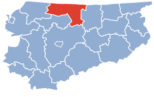
Bartoszyce County
County in Warmian-Masurian Voivodeship, Poland
Distance: Approx. 660 meters
Latitude and longitude: 54.25,20.8
Bartoszyce County (Polish: powiat bartoszycki) is a unit of territorial administration and local government (powiat) in Warmian-Masurian Voivodeship, northern Poland, on the border with Russia. It came into being on January 1, 1999, as a result of the Polish local government reforms passed in 1998. Its administrative seat and largest town is Bartoszyce, which lies 56 kilometres (35 mi) north of the regional capital Olsztyn.
Siege of Bartenstein
Distance: Approx. 316 meters
Latitude and longitude: 54.25111111,20.81083333
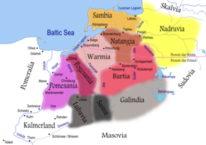
Siege of Bartenstein was a medieval siege laid upon the castle of Bartenstein (now Bartoszyce in Poland) by the Prussians during the Great Prussian Uprising. Bartenstein and Rößel (Reszel) were the two major Teutonic strongholds in Barta, one of the Prussian lands. The castle endured years of siege until 1264 and was one of the last to fall into the hands of the Prussians.

Gmina Bartoszyce
Gmina in Warmian-Masurian Voivodeship, Poland
Distance: Approx. 660 meters
Latitude and longitude: 54.25,20.8
Gmina Bartoszyce is a rural gmina (administrative district) in Bartoszyce County, Warmian-Masurian Voivodeship, in northern Poland, on the border with Russia. Its seat is the town of Bartoszyce, although the town is not part of the territory of the gmina. The gmina covers an area of 427.82 square kilometres (165.2 sq mi), and as of 2006 its total population is 10,769.
Ceglarki
Village in Warmian-Masurian Voivodeship, Poland
Distance: Approx. 2401 meters
Latitude and longitude: 54.23833333,20.83444444
Ceglarki [t͡sɛˈɡlarkʲi] (German: Ernsthof) is a village in the administrative district of Gmina Bartoszyce, within Bartoszyce County, Warmian-Masurian Voivodeship, in northern Poland, close to the border with the Kaliningrad Oblast of Russia.

Dąbrowa, Gmina Bartoszyce
Village in Warmian-Masurian Voivodeship, Poland
Distance: Approx. 2333 meters
Latitude and longitude: 54.27444444,20.80694444
Dąbrowa [dɔmˈbrɔva] (German: Damerau) is a village in the administrative district of Gmina Bartoszyce, within Bartoszyce County, Warmian-Masurian Voivodeship, in northern Poland, close to the border with the Kaliningrad Oblast of Russia.
Falczewo
Village in Warmian-Masurian Voivodeship, Poland
Distance: Approx. 2199 meters
Latitude and longitude: 54.26555556,20.835
Falczewo [falˈt͡ʂɛvɔ] (German: Fauthshof) is a village in the administrative district of Gmina Bartoszyce, within Bartoszyce County, Warmian-Masurian Voivodeship, in northern Poland, close to the border with the Kaliningrad Oblast of Russia.

Jarkowo, Warmian-Masurian Voivodeship
Village in Warmian-Masurian Voivodeship, Poland
Distance: Approx. 1843 meters
Latitude and longitude: 54.26694444,20.79166667
Jarkowo [jarˈkɔvɔ] (German: Erwienen) is a village in the administrative district of Gmina Bartoszyce, within Bartoszyce County, Warmian-Masurian Voivodeship, in northern Poland, close to the border with the Kaliningrad Oblast of Russia.
Okopa
Settlement in Warmian-Masurian Voivodeship, Poland
Distance: Approx. 2545 meters
Latitude and longitude: 54.25027778,20.84694444
Okopa [ɔˈkɔpa] (German: Erdmannshof) is a settlement in the administrative district of Gmina Bartoszyce, within Bartoszyce County, Warmian-Masurian Voivodeship, in northern Poland, close to the border with the Kaliningrad Oblast of Russia.
Połęcze
Village in Warmian-Masurian Voivodeship, Poland
Distance: Approx. 1905 meters
Latitude and longitude: 54.23638889,20.8075
Połęcze [pɔˈwɛnt͡ʂɛ] (German: Polenzhof) is a village in the administrative district of Gmina Bartoszyce, within Bartoszyce County, Warmian-Masurian Voivodeship, in northern Poland, close to the border with the Kaliningrad Oblast of Russia.
Wawrzyny
Village in Warmian-Masurian Voivodeship, Poland
Distance: Approx. 1949 meters
Latitude and longitude: 54.24166667,20.83027778
Wawrzyny [vaˈvʐɨnɨ] (German: Laurienen) is a village in the administrative district of Gmina Bartoszyce, within Bartoszyce County, Warmian-Masurian Voivodeship, in northern Poland, close to the border with the Kaliningrad Oblast of Russia.
Wiatrak, Warmian-Masurian Voivodeship
Village in Warmian-Masurian Voivodeship, Poland
Distance: Approx. 1994 meters
Latitude and longitude: 54.26055556,20.83638889
Wiatrak [ˈvʲatrak] (German: Schreibershöfchen) is a village in the administrative district of Gmina Bartoszyce, within Bartoszyce County, Warmian-Masurian Voivodeship, in northern Poland, close to the border with the Kaliningrad Oblast of Russia.
Weather in this IP's area
overcast clouds
1 Celsius
-3 Celsius
1 Celsius
1 Celsius
1044 hPa
82 %
1044 hPa
1033 hPa
10000 meters
5.08 m/s
8.71 m/s
118 degree
100 %