95.160.236.195 - IP Lookup: Free IP Address Lookup, Postal Code Lookup, IP Location Lookup, IP ASN, Public IP
Country:
 Poland
Region:
City:
Location:
Time Zone:
Postal Code:
ISP:
ASN:
language:
User-Agent:
Proxy IP:
Blacklist:
IP information under different IP Channel
ip-api
Country
Region
City
ASN
Time Zone
ISP
Blacklist
Proxy
Latitude
Longitude
Postal
Route
db-ip
Country
Region
City
ASN
Time Zone
ISP
Blacklist
Proxy
Latitude
Longitude
Postal
Route
IPinfo
Country
Region
City
ASN
Time Zone
ISP
Blacklist
Proxy
Latitude
Longitude
Postal
Route
IP2Location
95.160.236.195Country
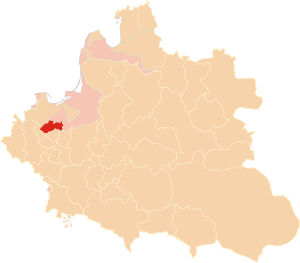
plRegion
kujawsko-pomorskie
City
chelmno
Time Zone
Europe/Warsaw
ISP
Language
User-Agent
Latitude
Longitude
Postal
ipdata
Country
Region
City
ASN
Time Zone
ISP
Blacklist
Proxy
Latitude
Longitude
Postal
Route
Popular places and events near this IP address

Chełmno
Town in Kuyavian-Pomeranian, Poland
Distance: Approx. 155 meters
Latitude and longitude: 53.34916667,18.42305556
Chełmno ([ˈxɛu̯mnɔ] ; older English: Culm; German: , formerly also Culm) is a town in northern Poland near the Vistula river with 18,915 inhabitants as of December 2021. It is the seat of the Chełmno County in the Kuyavian-Pomeranian Voivodeship. Due to its regional importance in the Middle Ages, the town gave its name to the entire area, Chełmno Land (and later an administrative unit of the Kingdom of Poland, the Chełmno Voivodeship), the local Catholic diocese and Kulm law, a municipal form of government for cities and towns around Poland, including the current capital city of Warsaw.
Chełmno Voivodeship
Former administrative division in Poland
Distance: Approx. 131 meters
Latitude and longitude: 53.349558,18.42422
The Chełmno Voivodeship (Polish: Województwo chełmińskie) was a unit of administrative division and local government in the Kingdom of Poland since 1454/1466 until the Partitions of Poland in 1772/1793. Its capital was at Chełmno. Together with the Pomeranian and Malbork Voivodeships and the Prince-Bishopric of Warmia it formed the province of Royal Prussia, and with several other voivodeships it formed the Greater Poland Province.

Chełmno County
County in Kuyavian-Pomeranian Voivodeship, Poland
Distance: Approx. 1936 meters
Latitude and longitude: 53.36583333,18.42277778
Chełmno County (Polish: powiat chełmiński) is a unit of territorial administration and local government (powiat) in Kuyavian-Pomeranian Voivodeship, north-central Poland. It came into being on 1 January 1999, as a result of the Polish local government reforms adopted in 1998. Its administrative seat and only town is Chełmno, which lies 40 km (25 mi) north of Toruń and 40 km (25 mi) north-east of Bydgoszcz.

Gmina Chełmno
Gmina in Kuyavian-Pomeranian Voivodeship, Poland
Distance: Approx. 1936 meters
Latitude and longitude: 53.36583333,18.42277778
Gmina Chełmno is a rural gmina (administrative district) in Chełmno County, Kuyavian-Pomeranian Voivodeship, in north-central Poland. Its seat is the town of Chełmno, although the town is not part of the territory of the gmina. The gmina covers an area of 114.05 square kilometres (44.0 sq mi), and as of 2006 its total population is 5,239.
Kosowo, Świecie County
Village in Kuyavian-Pomeranian Voivodeship, Poland
Distance: Approx. 4377 meters
Latitude and longitude: 53.36666667,18.36666667
Kosowo [kɔˈsɔvɔ] is a village in the administrative district of Gmina Świecie, within Świecie County, Kuyavian-Pomeranian Voivodeship, in north-central Poland. It lies approximately 8 kilometres (5 mi) south-west of Świecie, 37 km (23 mi) north-east of Bydgoszcz, and 41 km (25 mi) north-west of Toruń.
Brzozowo, Kuyavian-Pomeranian Voivodeship
Village in Kuyavian-Pomeranian Voivodeship, Poland
Distance: Approx. 3586 meters
Latitude and longitude: 53.31666667,18.43333333
Brzozowo [bʐɔˈzɔvɔ] is a village in the administrative district of Gmina Kijewo Królewskie, within Chełmno County, Kuyavian-Pomeranian Voivodeship, in north-central Poland. It lies approximately 5 kilometres (3 mi) north of Kijewo Królewskie, 6 km (4 mi) south of Chełmno, 34 km (21 mi) north of Toruń, and 37 km (23 mi) north-east of Bydgoszcz. It is located in the Chełmno Land in the historic region of Pomerania.
Kałdus
Village in Kuyavian-Pomeranian Voivodeship, Poland
Distance: Approx. 3431 meters
Latitude and longitude: 53.32194444,18.39888889
Kałdus [ˈkau̯dus] is a village in the administrative district of Gmina Chełmno, within Chełmno County, Kuyavian-Pomeranian Voivodeship, in north-central Poland. It lies 6 kilometres (4 mi) south of Chełmno, 36 km (22 mi) north-west of Toruń, and 36 km (22 mi) north-east of Bydgoszcz.
Osnowo
Village in Kuyavian-Pomeranian Voivodeship, Poland
Distance: Approx. 1860 meters
Latitude and longitude: 53.33194444,18.42888889
Osnowo [ɔsˈnɔvɔ] is a village in the administrative district of Gmina Chełmno, within Chełmno County, Kuyavian-Pomeranian Voivodeship, in north-central Poland. It lies 4 kilometres (2 mi) south of Chełmno, 36 km (22 mi) north of Toruń, and 38 km (24 mi) north-east of Bydgoszcz.

Grubno
Village in Kuyavian-Pomeranian Voivodeship, Poland
Distance: Approx. 3072 meters
Latitude and longitude: 53.34194444,18.47
Grubno [ˈɡrubnɔ] is a village in the administrative district of Gmina Stolno, within Chełmno County, Kuyavian-Pomeranian Voivodeship, in north-central Poland. It lies 4 kilometres (2 mi) north-west of Stolno, 5 km (3 mi) south-east of Chełmno, 36 km (22 mi) north of Toruń, and 41 km (25 mi) north-east of Bydgoszcz. It is located in Chełmno Land within the historic region of Pomerania.
Głogówko Królewskie
Village in Kuyavian-Pomeranian Voivodeship, Poland
Distance: Approx. 4221 meters
Latitude and longitude: 53.38333333,18.4
Głogówko Królewskie [ɡwɔˈɡufkɔ kruˈlɛfskʲɛ] is a village in the administrative district of Gmina Świecie, within Świecie County, Kuyavian-Pomeranian Voivodeship, in north-central Poland. It lies approximately 5 kilometres (3 mi) south-west of Świecie, 40 km (25 mi) north-east of Bydgoszcz, and 42 km (26 mi) north of Toruń.
Niedźwiedź, Świecie County
Village in Kuyavian-Pomeranian Voivodeship, Poland
Distance: Approx. 3434 meters
Latitude and longitude: 53.36666667,18.38333333
Niedźwiedź [ˈɲɛd͡ʑvjɛt͡ɕ] is a village in the administrative district of Gmina Świecie, within Świecie County, Kuyavian-Pomeranian Voivodeship, in north-central Poland. It lies approximately 7 kilometres (4 mi) south-west of Świecie, 38 km (24 mi) north-east of Bydgoszcz, and 41 km (25 mi) north-west of Toruń.

Church of the Assumption of the Blessed Virgin Mary in Chełmno
Church in Chełmno, Poland
Distance: Approx. 233 meters
Latitude and longitude: 53.348,18.42169444
The Church of the Assumption of the Blessed Virgin Mary (Polish: Kościół Wniebowzięcia Najświętszej Maryi Panny w Chełmnie) is a Catholic church in Chełmno, Poland. It was founded in the 13th century, and its gothic style is considered notably well preserved. The church was an influence for the Cathedral at Königsberg.
Weather in this IP's area
scattered clouds
2 Celsius
1 Celsius
1 Celsius
2 Celsius
1041 hPa
84 %
1041 hPa
1032 hPa
10000 meters
1.34 m/s
2.24 m/s
8 degree
25 %