95.160.16.6 - IP Lookup: Free IP Address Lookup, Postal Code Lookup, IP Location Lookup, IP ASN, Public IP
Country:
Region:
City:
Location:
Time Zone:
Postal Code:
ISP:
ASN:
language:
User-Agent:
Proxy IP:
Blacklist:
IP information under different IP Channel
ip-api
Country
Region
City
ASN
Time Zone
ISP
Blacklist
Proxy
Latitude
Longitude
Postal
Route
db-ip
Country
Region
City
ASN
Time Zone
ISP
Blacklist
Proxy
Latitude
Longitude
Postal
Route
IPinfo
Country
Region
City
ASN
Time Zone
ISP
Blacklist
Proxy
Latitude
Longitude
Postal
Route
IP2Location
95.160.16.6Country
Region
pomorskie
City
ustka
Time Zone
Europe/Warsaw
ISP
Language
User-Agent
Latitude
Longitude
Postal
ipdata
Country
Region
City
ASN
Time Zone
ISP
Blacklist
Proxy
Latitude
Longitude
Postal
Route
Popular places and events near this IP address

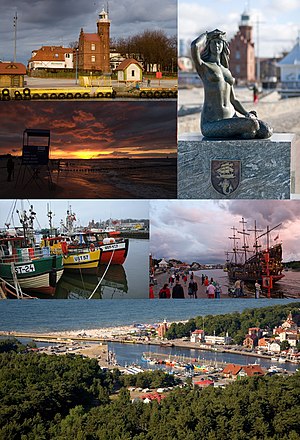
Ustka
Place in Pomeranian Voivodeship, Poland
Distance: Approx. 830 meters
Latitude and longitude: 54.58333333,16.85
Ustka (Polish pronunciation: [ˈustka], Kashubian: Ùskô, German: Stolpmünde) is a spa town in the Middle Pomerania region of northern Poland with 17,100 inhabitants (2001). It is part of Słupsk County in Pomeranian Voivodeship. It is located on the Slovincian Coast on the Baltic Sea.

Słupia
River in Poland
Distance: Approx. 1104 meters
Latitude and longitude: 54.5889,16.8528
Słupia (German: Stolpe) is a river in north-western Poland, a tributary of the Baltic Sea, with a length of 138 kilometres and the basin area of 1,623 km². Towns: Słupsk Ustka Affluents: Bytowa See also: Rivers of Poland, List of rivers of Europe.
Gmina Ustka
Gmina in Pomeranian Voivodeship, Poland
Distance: Approx. 830 meters
Latitude and longitude: 54.58333333,16.85
Gmina Ustka is a rural gmina (administrative district) in Słupsk County, Pomeranian Voivodeship, in northern Poland. Its seat is the town of Ustka, although the town is not part of the territory of the gmina. The gmina covers an area of 218.1 square kilometres (84.2 sq mi), and as of 2006 its total population is 7,335.
Grabno, Pomeranian Voivodeship
Village in Pomeranian Voivodeship, Poland
Distance: Approx. 3893 meters
Latitude and longitude: 54.56027778,16.91111111
Grabno [ˈɡrabnɔ] (German: Wintershagen) is a village in the administrative district of Gmina Ustka, within Słupsk County, Pomeranian Voivodeship, in northern Poland. It lies approximately 5 kilometres (3 mi) south-east of Ustka, 13 km (8 mi) north-west of Słupsk, and 114 km (71 mi) west of the regional capital Gdańsk. For the history of the region, see History of Pomerania.
Lędowo, Słupsk County
Village in Pomeranian Voivodeship, Poland
Distance: Approx. 3772 meters
Latitude and longitude: 54.56027778,16.815
Lędowo [lɛnˈdɔvɔ] (German: Lindow) is a village in the administrative district of Gmina Ustka, within Słupsk County, Pomeranian Voivodeship, in northern Poland. It lies approximately 4 kilometres (2 mi) south-west of Ustka, 18 km (11 mi) north-west of Słupsk, and 120 km (75 mi) west of the regional capital Gdańsk. For the history of the region, see History of Pomerania.
Lędowo-Osiedle
Village in Pomeranian Voivodeship, Poland
Distance: Approx. 2921 meters
Latitude and longitude: 54.57138889,16.81944444
Lędowo-Osiedle [lɛnˈdɔvɔ ɔˈɕɛdlɛ] is a village in the administrative district of Gmina Ustka, within Słupsk County, Pomeranian Voivodeship, in northern Poland. It lies approximately 3 kilometres (2 mi) south-west of Ustka, 18 km (11 mi) north-west of Słupsk, and 120 km (75 mi) west of the regional capital Gdańsk. For the history of the region, see History of Pomerania.

Przewłoka, Pomeranian Voivodeship
Village in Pomeranian Voivodeship, Poland
Distance: Approx. 2658 meters
Latitude and longitude: 54.57944444,16.90305556
Przewłoka [pʂɛˈvwɔka] (German: Strickershagen) is a village in the administrative district of Gmina Ustka, within Słupsk County, Pomeranian Voivodeship, in northern Poland. It lies approximately 4 kilometres (2 mi) east of Ustka, 16 km (10 mi) north-west of Słupsk, and 115 km (71 mi) west of the regional capital Gdańsk. For the history of the region, see History of Pomerania.
Wodnica-Kolonia
Settlement in Pomeranian Voivodeship, Poland
Distance: Approx. 4021 meters
Latitude and longitude: 54.54722222,16.88611111
Wodnica-Kolonia [vɔdˈnit͡sa kɔˈlɔɲa] is a settlement in the administrative district of Gmina Ustka, within Słupsk County, Pomeranian Voivodeship, in northern Poland. It lies approximately 5 kilometres (3 mi) south-east of Ustka, 13 km (8 mi) north-west of Słupsk, and 115 km (71 mi) west of the regional capital Gdańsk. For the history of the region, see History of Pomerania.
Zapadłe, Słupsk County
Village in Pomeranian Voivodeship, Poland
Distance: Approx. 3724 meters
Latitude and longitude: 54.58888889,16.91777778
Zapadłe [zaˈpadwɛ] is a village in the administrative district of Gmina Ustka, within Słupsk County, Pomeranian Voivodeship, in northern Poland. It lies approximately 5 kilometres (3 mi) east of Ustka, 16 km (10 mi) north-west of Słupsk, and 114 km (71 mi) west of the regional capital Gdańsk. For the history of the region, see History of Pomerania.
Zimowiska
Village in Pomeranian Voivodeship, Poland
Distance: Approx. 4263 meters
Latitude and longitude: 54.55861111,16.91611111
Zimowiska [ʑimɔˈviska] is a village in the administrative district of Gmina Ustka, within Słupsk County, Pomeranian Voivodeship, in northern Poland. It lies approximately 6 kilometres (4 mi) south-east of Ustka, 13 km (8 mi) north-west of Słupsk, and 114 km (71 mi) west of the regional capital Gdańsk. For the history of the region, see History of Pomerania.

Ustka railway station
Railway station in Ustka, Poland
Distance: Approx. 192 meters
Latitude and longitude: 54.57888889,16.86083333
Ustka railway station is in Ustka in the Pomeranian Voivodeship, Poland. According to the PKP classification the station is category D, meaning it has fewer than 300,000 passengers annually.

Ustka Lighthouse
Lighthouse in Poland
Distance: Approx. 950 meters
Latitude and longitude: 54.58791667,16.85461111
Ustka Lighthouse (Polish: Latarnia Morska Ustka) is a lighthouse located in Ustka (formerly Stolpmünde), on the Polish coast of the Baltic Sea. The lighthouse is located in between the Jarosławiec Lighthouse and the Czołpino Lighthouse.
Weather in this IP's area
moderate rain
4 Celsius
2 Celsius
4 Celsius
4 Celsius
1025 hPa
81 %
1025 hPa
1023 hPa
10000 meters
2.18 m/s
2.21 m/s
206 degree
5 %