Country:
Region:
City:
Latitude and Longitude:
Time Zone:
Postal Code:
IP information under different IP Channel
ip-api
Country
Region
City
ASN
Time Zone
ISP
Blacklist
Proxy
Latitude
Longitude
Postal
Route
Luminati
Country
Region
rp
City
enkenbachalsenborn
ASN
Time Zone
Europe/Berlin
ISP
VSE NET GmbH
Latitude
Longitude
Postal
IPinfo
Country
Region
City
ASN
Time Zone
ISP
Blacklist
Proxy
Latitude
Longitude
Postal
Route
db-ip
Country
Region
City
ASN
Time Zone
ISP
Blacklist
Proxy
Latitude
Longitude
Postal
Route
ipdata
Country
Region
City
ASN
Time Zone
ISP
Blacklist
Proxy
Latitude
Longitude
Postal
Route
Popular places and events near this IP address

Enkenbach-Alsenborn
Municipality in Rhineland-Palatinate, Germany
Distance: Approx. 1250 meters
Latitude and longitude: 49.49055556,7.9025
Enkenbach-Alsenborn is a municipality in the district of Kaiserslautern, in Rhineland-Palatinate, Germany. It is situated on the northern edge of the Palatinate forest, approx. 10 km north-east of Kaiserslautern.

Hochspeyer
Municipality in Rhineland-Palatinate, Germany
Distance: Approx. 4144 meters
Latitude and longitude: 49.44277778,7.89666667
Hochspeyer is a municipality in the district of Kaiserslautern, in Rhineland-Palatinate, Germany. It is situated in the Palatinate forest (Pfälzer Wald), approx. 10 km east of Kaiserslautern.

Sembach
Municipality in Rhineland-Palatinate, Germany
Distance: Approx. 4560 meters
Latitude and longitude: 49.51361111,7.86055556
Sembach is a municipality in the district of Kaiserslautern in the state of Rhineland-Palatinate, Germany. It forms part of the Verbandsgemeinde of Enkenbach-Alsenborn. The town is nestled in the Palatinate Forest Nature Park between Kaiserslautern and Donnersbergkreis.
Enkenbach-Alsenborn (Verbandsgemeinde)
Verbandsgemeinde in Rhineland-Palatinate, Germany
Distance: Approx. 1250 meters
Latitude and longitude: 49.49055556,7.9025
Enkenbach-Alsenborn is a Verbandsgemeinde ("collective municipality") in the district of Kaiserslautern, in Rhineland-Palatinate, Germany. Its seat is located in Enkenbach-Alsenborn. It consists of the following Ortsgemeinden ("local municipalities"): Enkenbach-Alsenborn Fischbach Frankenstein Hochspeyer Mehlingen Neuhemsbach Sembach Waldleiningen Originally established on 7 June 1969 from the combination of the villages of Enkenbach and Alsenborn, it was expanded to include the villages of Sembach, Mehlingen and Neuhemsbach on 22 April 1972.

Fischbach, Kaiserslautern
Municipality in Rhineland-Palatinate, Germany
Distance: Approx. 3055 meters
Latitude and longitude: 49.45472222,7.91305556
Fischbach is a municipality in the district of Kaiserslautern, in Rhineland-Palatinate, western Germany.

Mehlingen
Municipality in Rhineland-Palatinate, Germany
Distance: Approx. 3344 meters
Latitude and longitude: 49.49194444,7.85416667
Mehlingen is a municipality in the district of Kaiserslautern, in Rhineland-Palatinate, western Germany. It is located 5 km (3.1 mi) outside Kaiserslautern and has a population of just under 4,000. The village is greatly influenced by the large number of Americans stationed in the area, often called the Kaiserslautern Military Community.
Hochspeyer (Verbandsgemeinde)
Distance: Approx. 4120 meters
Latitude and longitude: 49.443,7.895
Hochspeyer is a former Verbandsgemeinde ("collective municipality") in the district of Kaiserslautern, Rhineland-Palatinate, Germany. The seat of the Verbandsgemeinde was in Hochspeyer. On 1 July 2014 it merged into the Verbandsgemeinde Enkenbach-Alsenborn.
Franzosenwoog
Distance: Approx. 4911 meters
Latitude and longitude: 49.44138889,7.92944444
Franzosenwoog is a former reservoir in Pfälzerwald, Rhineland-Palatinate, Germany. It was created around 1828 to facilitate timber rafting on the nearby Hochspeyerbach and ceased to exist around 1885.

Alsenborn
Ortsteil of Enkenbach-Alsenborn in Rhineland-Palatinate, Germany
Distance: Approx. 888 meters
Latitude and longitude: 49.486667,7.903333
Alsenborn (German pronunciation: [ˈalzn̩ˌbɔʁn] ) is a village forming part of the municipality of Enkenbach-Alsenborn within the district of Kaiserslautern in the German state of Rhineland-Palatinate. It has a population of 2,750. Until 1969 Alsenborn was an independent parish before merging with Enkenbach under the administrative reforms in the state.

Queitersberg
Distance: Approx. 4734 meters
Latitude and longitude: 49.450104,7.850068
The Queitersberg, more rarely spelt Quaidersberg, Quaitersberg or Queidersberg, is a 394-metre-high hill in the northern Palatine Forest in the German state of Rhineland-Palatinate. On a subpeak is the natural monument of the Felsplatt, a rock formation.

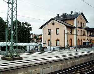
Enkenbach station
Railway station in Enkenbach-Alsenborn, Germany
Distance: Approx. 1162 meters
Latitude and longitude: 49.490277,7.899406
Enkenbach station is the only station in Enkenbach-Alsenborn in the German state of Rhineland-Palatinate. It has two platforms tracks and is located in the network of the Verkehrsverbund Rhein-Neckar (Rhine-Neckar transport association, VRN) and belongs to fare zone 828. Its address is Bahnhofstraße 2.

Hochspeyer station
Railway station in Hochspeyer, Germany
Distance: Approx. 4038 meters
Latitude and longitude: 49.4441,7.9046
Hochspeyer station – originally officially Neuhochspeyer or Neu-Hochspeyer – is the station of the town of Hochspeyer in the German state of Rhineland-Palatinate. Deutsche Bahn classifies it as belonging to category 4 and it has four platform tracks. The station is located in the network of the Verkehrsverbund Rhein-Neckar (Rhine-Neckar transport association, VRN) and belongs to fare zone 100.
Weather in this IP's area
clear sky
5 Celsius
5 Celsius
4 Celsius
6 Celsius
1027 hPa
98 %
1027 hPa
989 hPa
10000 meters
0.34 m/s
0.34 m/s
91 degree
07:31:56
16:52:54
