Country:
 Great Britain
Region:
City:
Latitude and Longitude:
Time Zone:
Postal Code:
IP information under different IP Channel
ip-api
Country
Region
City
ASN
Time Zone
ISP
Blacklist
Proxy
Latitude
Longitude
Postal
Route
IPinfo
Country
Region
City
ASN
Time Zone
ISP
Blacklist
Proxy
Latitude
Longitude
Postal
Route
MaxMind
Country
Region
City
ASN
Time Zone
ISP
Blacklist
Proxy
Latitude
Longitude
Postal
Route
Luminati
Country
GBASN
Time Zone
Europe/London
ISP
Exponential-E Ltd.
Latitude
Longitude
Postal
db-ip
Country
Region
City
ASN
Time Zone
ISP
Blacklist
Proxy
Latitude
Longitude
Postal
Route
ipdata
Country
Region
City
ASN
Time Zone
ISP
Blacklist
Proxy
Latitude
Longitude
Postal
Route
Popular places and events near this IP address

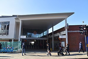
West Hampstead tube station
London Underground station
Distance: Approx. 143 meters
Latitude and longitude: 51.54694444,-0.19055556
West Hampstead is a London Underground station in West Hampstead. It is located on West End Lane between Broadhurst Gardens and Blackburn Road and is situated in Travelcard Zone 2. It is on the Jubilee line between Kilburn and Finchley Road stations.
Stations in West Hampstead
Transport stations in West Hampstead, London
Distance: Approx. 59 meters
Latitude and longitude: 51.5475,-0.19138889
West Hampstead is an area in north-west London, England that is served by a number of different stations, all of which have very similar names. Although physically separate, they are near each other and the stations form a railway interchange. Two of the stations are part of the National Rail network and the third is on the London Underground.

West Hampstead Thameslink railway station
National rail (Thameslink) station in London, England
Distance: Approx. 92 meters
Latitude and longitude: 51.5484,-0.193
West Hampstead Thameslink is a National Rail station on the Midland Main Line and is served by Thameslink trains as part of the Thameslink route between Kentish Town and Cricklewood. The station is in Travelcard Zone 2.

Hampstead and Kilburn (UK Parliament constituency)
Parliamentary constituency in the United Kingdom, 2010–2024
Distance: Approx. 188 meters
Latitude and longitude: 51.549,-0.194
Hampstead and Kilburn was a constituency created in 2010 and represented in the House of Commons from 2015 until its abolition for the 2024 general election by Tulip Siddiq of the Labour Party. Glenda Jackson was the MP from 2010 to 2015, having served for the predecessor seat since 1992. Under the 2023 Periodic Review of Westminster constituencies, the majority of the constituency - excluding the Borough of Brent wards of Brondesbury Park, Kilburn and Queen's Park - was incorporated into the re-established seat of Hampstead and Highgate.

Kilburn Grange Park
Distance: Approx. 574 meters
Latitude and longitude: 51.54388889,-0.1975
Kilburn Grange Park is a 3.2 hectares (7.9 acres) open space in Kilburn, north-west London adjacent to Kilburn High Road. It is administered by the London Borough of Camden and includes a children's playground, basketball court, outdoor gym equipment and tennis courts. The park first opened in 1913 having previously been part of the Grange estate.
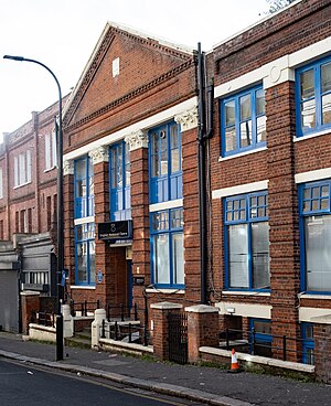
Decca Studios
Former recording studio in West Hampstead, London
Distance: Approx. 204 meters
Latitude and longitude: 51.5463,-0.1904
Decca Studios was a recording facility at 165 Broadhurst Gardens, West Hampstead, North London, England, controlled by Decca Records from 1937 to 1980.
West Hampstead railway station
London Overground station
Distance: Approx. 59 meters
Latitude and longitude: 51.5473,-0.1918
West Hampstead railway station is a London Overground station on the North London Line between Brondesbury and Finchley Road & Frognal in the London Borough of Camden and is in Travelcard Zone 2. The station and all trains are operated by London Overground. The station entrance is on West End Lane.

West End Lane
Street in London, England
Distance: Approx. 243 meters
Latitude and longitude: 51.54566,-0.19137
West End Lane is a street in inner north-west London, England (grid reference TQ2585) that runs for about one mile between Kilburn High Road to the south and Finchley Road to the north. Located in the London Borough of Camden, and the NW6 postal district, the street winds through West Hampstead with a mix of residential and commercial buildings. The three West Hampstead stations are all located on the road at the centre of the district of that name.
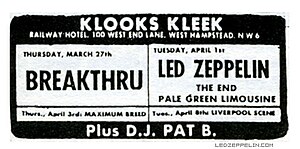
Klooks Kleek
London music venue of the 1960s
Distance: Approx. 183 meters
Latitude and longitude: 51.5463,-0.191
Klooks Kleek was a jazz and rhythm 'n’ blues club on the first floor of the Railway Hotel, West Hampstead, north-west London. Named after "Klook's Clique", a 1956 album by jazz drummer Kenny Clarke (Savoy Records 12006), the club opened on 11 January 1961 with special guest Don Rendell (tenor sax) and closed nine years later on 28 January 1970 after a session by drummer Keef Hartley’s group. There were over 1200 sessions at Klook’s Kleek, around 300 of them featuring jazz, and the others rhythm ‘n’ blues.

Hampstead Synagogue
Orthodox Jewish synagogue in Hampstead, London, England
Distance: Approx. 223 meters
Latitude and longitude: 51.5498,-0.192
Hampstead Synagogue is an Orthodox Jewish congregation and synagogue, located on Dennington Park Road, West Hampstead, in the Borough of Camden, London, England, in the United Kingdom. The synagogue building was completed in 1901 and was Grade II* listed with English Heritage in 1989. The congregation is a member of the United Synagogue and has been led by Rabbi Dr Michael Harris since 1995.

Emmanuel Church, West Hampstead
Church in London , England
Distance: Approx. 546 meters
Latitude and longitude: 51.5527,-0.1925
Emmanuel Church is a historic Grade II church in West Hampstead, a suburb of London, England.

Shir Hayim
Former Reformer synagogue in London, England
Distance: Approx. 462 meters
Latitude and longitude: 51.5466,-0.1857
Shir Hayim ("A Song of Life") was a Reform Jewish congregation and synagogue, located at 37a Broadhurst Gardens, in West Hampstead, in the Borough of Camden, London, England, in the United Kingdom. Established in 1975, the congregation closed in 2020 when it was merged with Willesden Minyan to form the Makor Hayim congregation.
Weather in this IP's area
clear sky
11 Celsius
10 Celsius
9 Celsius
12 Celsius
1015 hPa
92 %
1015 hPa
1008 hPa
10000 meters
2.06 m/s
210 degree
07:31:59
17:59:02