Country:
 Italy
ItalyRegion:
City:
Latitude and Longitude:
Time Zone:
Postal Code:
IP information under different IP Channel
ip-api
Country
Region
City
ASN
Time Zone
ISP
Blacklist
Proxy
Latitude
Longitude
Postal
Route
IPinfo
Country
Region
City
ASN
Time Zone
ISP
Blacklist
Proxy
Latitude
Longitude
Postal
Route
MaxMind
Country
Region
City
ASN
Time Zone
ISP
Blacklist
Proxy
Latitude
Longitude
Postal
Route
Luminati
Country
ITASN
Time Zone
Europe/Rome
ISP
Seflow s.r.l.
Latitude
Longitude
Postal
db-ip
Country
Region
City
ASN
Time Zone
ISP
Blacklist
Proxy
Latitude
Longitude
Postal
Route
ipdata
Country
Region
City
ASN
Time Zone
ISP
Blacklist
Proxy
Latitude
Longitude
Postal
Route
Popular places and events near this IP address

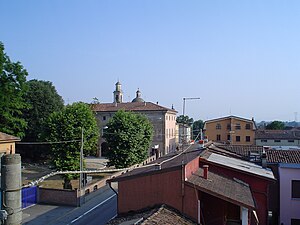
Codogno
Comune in Lombardy, Italy
Distance: Approx. 109 meters
Latitude and longitude: 45.16,9.705
Codogno (Italian pronunciation: [koˈdoɲɲo]; Lodigiano: Cudògn) is a town and comune of 15,868 inhabitants in the province of Lodi, Lombardy, northern Italy. It is the main center of the plain known as Basso Lodigiano, which has about 90,000 inhabitants. It received the honorary title of city with a presidential decree on June 26, 1955.

Camairago
Frazione in Lombardy, Italy
Distance: Approx. 4610 meters
Latitude and longitude: 45.2,9.71666667
Camairago is a frazione of Castelgerundo in the Province of Lodi in the Italian region Lombardy, located about 50 kilometres (31 mi) southeast of Milan and about 20 kilometres (12 mi) southeast of Lodi. From 1 January 2018 the comune was unified with Cavacurta and the new municipality took the name of Castelgerundo.

Cavacurta
Frazione in Lombardy, Italy
Distance: Approx. 4610 meters
Latitude and longitude: 45.2,9.71666667
Cavacurta is a frazione of Castelgerundo in the Province of Lodi in the Italian region Lombardy, located about 50 kilometres (31 mi) southeast of Milan and about 20 kilometres (12 mi) southeast of Lodi. From 1 January 2018 the comune was unified with Camairago and the new municipality took the name of Castelgerundo.
Fombio
Comune in Lombardy, Italy
Distance: Approx. 1108 meters
Latitude and longitude: 45.15,9.7
Fombio (Lodigiano: Fùmbi) is a comune (municipality) in the Province of Lodi in the Italian region Lombardy, located about 50 kilometres (31 mi) southeast of Milan and about 25 kilometres (16 mi) southeast of Lodi. It was the site of the Battle of Fombio in 1796. Fombio borders the following municipalities: Codogno, Somaglia, San Fiorano, Santo Stefano Lodigiano, Guardamiglio, San Rocco al Porto.

Guardamiglio
Comune in Lombardy, Italy
Distance: Approx. 1108 meters
Latitude and longitude: 45.15,9.7
Guardamiglio (Lodigiano: Guardamèi) is a comune (municipality) in the Province of Lodi in the Italian region Lombardy, located about 50 kilometres (31 mi) southeast of Milan, about 25 kilometres (16 mi) southeast of Lodi, and 15 kilometres (9 mi) north of Piacenza. Guardamiglio borders the following municipalities: Somaglia, Fombio, Calendasco, San Rocco al Porto.

Maleo, Lombardy
Comune in Lombardy, Italy
Distance: Approx. 5002 meters
Latitude and longitude: 45.16666667,9.76666667
Maleo (Lodigiano: Malé) is a comune (municipality) in the Province of Lodi in the Italian region Lombardy, located about 60 kilometres (37 mi) southeast of Milan and about 25 kilometres (16 mi) southeast of Lodi. Maleo borders the following municipalities: Pizzighettone, Castelgerundo, Codogno, Cornovecchio, Corno Giovine, San Fiorano, Santo Stefano Lodigiano.

San Rocco al Porto
Comune in Lombardy, Italy
Distance: Approx. 1108 meters
Latitude and longitude: 45.15,9.7
San Rocco al Porto (Lodigiano, Piacentino: San Roch) is a comune (municipality) in the Province of Lodi in the Italian region Lombardy, located about 50 kilometres (31 mi) southeast of Milan and about 25 kilometres (16 mi) southeast of Lodi. As of 31 December 2020, it had a population of 5,983 and an area of 30.7 square kilometres (11.9 sq mi). San Rocco al Porto borders the following municipalities: Fombio, Santo Stefano Lodigiano, Calendasco, Guardamiglio, Piacenza.

Santo Stefano Lodigiano
Comune in Lombardy, Italy
Distance: Approx. 5002 meters
Latitude and longitude: 45.16666667,9.76666667
Santo Stefano Lodigiano (Lodigiano: San Steu) is a comune (municipality) in the Province of Lodi in the Italian region Lombardy, located about 60 kilometres (37 mi) southeast of Milan and about 25 kilometres (16 mi) southeast of Lodi. Santo Stefano Lodigiano borders the following municipalities: Maleo, Corno Giovine, Corno Giovine, Fombio, San Fiorano, Caselle Landi, Piacenza, Piacenza, San Rocco al Porto. The municipality is home to a Baby & Toy Museum with more than 1,700 items.

Terranova dei Passerini
Comune in Lombardy, Italy
Distance: Approx. 4383 meters
Latitude and longitude: 45.192,9.672
Terranova dei Passerini (Lodigiano: Teranöva) is a comune (municipality) in the Province of Lodi in the Italian region Lombardy, located about 50 kilometres (31 mi) southeast of Milan and about 20 kilometres (12 mi) southeast of Lodi. Terranova dei Passerini borders the following municipalities: Turano Lodigiano, Bertonico, Castiglione d'Adda, Casalpusterlengo, Castelgerundo, Codogno.
Retegno
Frazione in Lombardy, Italy
Distance: Approx. 1925 meters
Latitude and longitude: 45.15,9.68333333
Retegno is a small town within the municipality of Fombio, Lombardy, Italy.
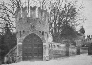
Trecchi Castle (Maleo)
Distance: Approx. 5002 meters
Latitude and longitude: 45.16666667,9.76666667
Trecchi Castle is a 15th-century fortress located in Maleo, Province of Lodi, Lombardy, Italy. The construction of the building is attributed to architect Pellegrino Tibaldi. The castle was transformed into a country villa over time.
Codogno rail crash
Distance: Approx. 643 meters
Latitude and longitude: 45.16,9.69555556
The Codogno rail crash happened at Codogno, Italy, in the early evening of 9 December 1957. Fifteen people were killed, and at least 30 were seriously injured. At 18:19 on 9 December 1957, the Milan–Rome express, while travelling through Codogno at a speed of 130 km/h (81 mph), struck a truck loaded with bran, which had become stuck at a level crossing.
Weather in this IP's area
few clouds
17 Celsius
17 Celsius
16 Celsius
17 Celsius
1019 hPa
80 %
1019 hPa
1012 hPa
10000 meters
1.25 m/s
1.85 m/s
50 degree
22 %
07:04:54
19:24:59