Country:
Region:
City:
Latitude and Longitude:
Time Zone:
Postal Code:
IP information under different IP Channel
ip-api
Country
Region
City
ASN
Time Zone
ISP
Blacklist
Proxy
Latitude
Longitude
Postal
Route
Luminati
Country
ASN
Time Zone
Europe/Rome
ISP
Seflow s.r.l.
Latitude
Longitude
Postal
IPinfo
Country
Region
City
ASN
Time Zone
ISP
Blacklist
Proxy
Latitude
Longitude
Postal
Route
db-ip
Country
Region
City
ASN
Time Zone
ISP
Blacklist
Proxy
Latitude
Longitude
Postal
Route
ipdata
Country
Region
City
ASN
Time Zone
ISP
Blacklist
Proxy
Latitude
Longitude
Postal
Route
Popular places and events near this IP address

Mugello
Distance: Approx. 9448 meters
Latitude and longitude: 43.95,11.3833
The Mugello (Italian pronunciation: [muˈdʒɛllo]) is a historic region and valley in northern Tuscany, Italy, corresponding to the course of the River Sieve. It is located to the north of the city of Florence and includes the northernmost portion of the Metropolitan City of Florence. The Futa Pass connects the Mugello valley to the separate Santerno river valley.

La Marzocco
Italian espresso machine manufacturer
Distance: Approx. 7353 meters
Latitude and longitude: 43.9625048,11.351572
La Marzocco, founded in 1927, Florence, by Giuseppe and Bruno Bambi, is an Italian company specializing in high-end espresso coffee machines. It is based in Scarperia, with branch offices worldwide.

Mugello Circuit
Motorsport venue in Italy
Distance: Approx. 4450 meters
Latitude and longitude: 43.9975,11.37194444
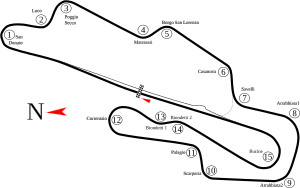
Mugello Circuit (Autodromo Internazionale del Mugello) is a motorsport race track in Scarperia e San Piero, Florence, Tuscany, Italy. The circuit length is 5.245 km (3.259 mi). It has 15 turns and a 1.141 km (0.709 mi) long straight.

Barberino di Mugello
Comune in Tuscany, Italy
Distance: Approx. 8219 meters
Latitude and longitude: 44.00138889,11.23916667
Barberino di Mugello is a comune (municipality) in the Metropolitan City of Florence in the Italian region Tuscany, located about 25 kilometres (16 mi) north of Florence. Barberino di Mugello borders the following municipalities: Calenzano, Cantagallo, Castiglione dei Pepoli, Firenzuola, San Piero a Sieve, Scarperia, Vaiano, Vernio. Sights include the Villa Medici of Cafaggiolo.
San Piero a Sieve
Frazione in Tuscany, Italy
Distance: Approx. 7592 meters
Latitude and longitude: 43.96,11.32166667
San Piero a Sieve is a frazione of the comune (municipality) of Scarperia e San Piero, located in the Metropolitan City of Florence, in Tuscany, Italy, about 20 kilometres (12 mi) north of Florence. It was an independent comune until 1 January 2014.
Futa Pass
Pass in the Tuscan-Emilian Apennines
Distance: Approx. 8647 meters
Latitude and longitude: 44.0935,11.2782
The Futa Pass or La Futa Pass (Italian: Passo della Futa) is a pass in the Tuscan-Emilian Apennines, at an elevation of 903 m (2,963 ft). It is located in the comune of Firenzuola, in the Metropolitan City of Florence. It separates the valleys of Mugello and of the Santerno River.

Villa Medici at Cafaggiolo
Historic estate in Tuscany, Italy
Distance: Approx. 7684 meters
Latitude and longitude: 43.96483889,11.29496389
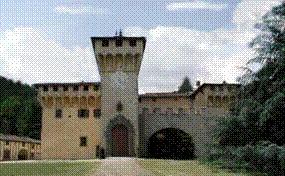
The Villa Medicea di Cafaggiolo is a villa situated near the Tuscan town of Barberino di Mugello in the valley of the River Sieve, some 25 kilometres north of Florence, central Italy. It was one of the oldest and most favoured of the Medici family estates, having been in the possession of the family since the 14th century, when it was owned by Averardo de' Medici. Averardo's son, Giovanni di Bicci de' Medici, is considered to be the founder of the Medici dynasty.

2008 Italian motorcycle Grand Prix
Distance: Approx. 4425 meters
Latitude and longitude: 43.99741667,11.37133333
The 2008 Italian motorcycle Grand Prix was the sixth round of the 2008 MotoGP championship. It took place on the weekend of 30 May – 1 June 2008 at the Mugello Circuit. It marked Valentino Rossi's seventh consecutive victory at the Italian motorcycle Grand Prix, a run which was to be finally broken the following year by Casey Stoner.

Villa del Trebbio
UNESCO World Heritage Site in Tuscany, Italy
Distance: Approx. 9153 meters
Latitude and longitude: 43.95305556,11.28666667
The Villa del Trebbio is a Medici villa in San Piero a Sieve, Tuscany, Italy.
Lake Bilancino
Distance: Approx. 8030 meters
Latitude and longitude: 43.97717222,11.26336389
Lake Bilancino is an artificial lake near Barberino di Mugello in the Metropolitan City of Florence, Tuscany, Italy, made with a dam on the river Sieve. At an elevation of 252 m, the lake surface area is approximately 5 km2.
Convent of Bosco ai Frati
Distance: Approx. 5236 meters
Latitude and longitude: 43.9862,11.3039
The Convent of Bosco ai Frati is located in the comune (municipality) of Scarperia e San Piero, in the midst of Turkey oak woods. The area is in the province of Florence in the Italian region Tuscany, and is situated about 25 kilometres (16 miles) northeast of Florence.

Futa Pass Cemetery
Cemetery in Firenzuola, Italy
Distance: Approx. 9159 meters
Latitude and longitude: 44.096125,11.272047
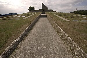
The German Futa Pass Cemetery (Deutsche Soldatenfriedhof Futapass; Cimitero militare germanico della Futa) is Italy's largest war cemetery. According to the German War Graves Commission it holds remains of 30,800 German soldiers who died in the Second World War. It is located at the summit of the Futa Pass (Passo della Futa, 903 m) in the Apennines and in Mugello, near Traversa in the commune of Firenzuola, that is, about 40 kilometers north of Florence and 40 kilometers south of Bologna along National Highway Nr.
Weather in this IP's area
overcast clouds
9 Celsius
8 Celsius
7 Celsius
11 Celsius
1024 hPa
78 %
1024 hPa
976 hPa
10000 meters
2.44 m/s
3.66 m/s
24 degree
90 %
07:03:29
16:53:51


