Country:
 Greece
Region:
City:
Latitude and Longitude:
Time Zone:
Postal Code:
IP information under different IP Channel
ip-api
Country
Region
City
ASN
Time Zone
ISP
Blacklist
Proxy
Latitude
Longitude
Postal
Route
IPinfo
Country
Region
City
ASN
Time Zone
ISP
Blacklist
Proxy
Latitude
Longitude
Postal
Route
MaxMind
Country
Region
City
ASN
Time Zone
ISP
Blacklist
Proxy
Latitude
Longitude
Postal
Route
Luminati
Country
GRRegion
g
City
agrinio
ASN
Time Zone
Europe/Athens
ISP
OTEnet S\.A\.
Latitude
Longitude
Postal
db-ip
Country
Region
City
ASN
Time Zone
ISP
Blacklist
Proxy
Latitude
Longitude
Postal
Route
ipdata
Country
Region
City
ASN
Time Zone
ISP
Blacklist
Proxy
Latitude
Longitude
Postal
Route
Popular places and events near this IP address

Actium
Town of ancient Acarnania in Greece
Distance: Approx. 1540 meters
Latitude and longitude: 38.953,20.768
Actium or Aktion (Ancient Greek: Ἄκτιον) was a town on a promontory in ancient Acarnania at the entrance of the Ambraciot Gulf, off which Octavian gained his celebrated victory, the Battle of Actium, over Antony and Cleopatra, on September 2, 31 BCE.
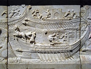
Battle of Actium
Naval battle between Octavian and Antony/Cleopatra (31 BC)
Distance: Approx. 3364 meters
Latitude and longitude: 38.925,20.725
The Battle of Actium was a naval battle fought between Octavian's maritime fleet, led by Marcus Agrippa, and the combined fleets of both Mark Antony and Cleopatra. The battle took place on 2 September 31 BC in the Ionian Sea, near the former Roman colony of Actium, Greece, and was the climax of over a decade of rivalry between Octavian and Antony. In early 31 BC, the year of the battle, Antony and Cleopatra were temporarily stationed in Greece.

Battle of Preveza
1538 battle of the Third Ottoman–Venetian War
Distance: Approx. 1421 meters
Latitude and longitude: 38.95916667,20.75027778
The Battle of Preveza (also known as Prevesa) was a naval engagement that took place on 28 September 1538 near Preveza in the Ionian Sea in northwestern Greece between an Ottoman fleet and that of a Holy League. The battle was an Ottoman victory which occurred in the same area in the Ionian Sea as the Battle of Actium in 31 BC. It was one of the three largest sea battles that took place in the sixteenth century Mediterranean, along with the Battle of Djerba and the Battle of Lepanto.
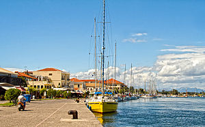
Preveza
Municipality in Greece
Distance: Approx. 1226 meters
Latitude and longitude: 38.9575,20.75166667
Preveza (Greek: Πρέβεζα, pronounced [ˈpreveza]) is a city in the region of Epirus, northwestern Greece, located on the northern peninsula of the mouth of the Ambracian Gulf. It is the capital of the regional unit of Preveza, which is the southern part of the region of Epirus. The Aktio-Preveza Immersed Tunnel –the first and so far only undersea tunnel in Greece– was completed in 2002.
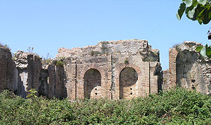
Nicopolis
Ancient city founded by Octavian after battle of Actium
Distance: Approx. 7071 meters
Latitude and longitude: 39.00833333,20.73361111
Nicopolis (Greek: Νικόπολις, translit. Nikópolis, lit. "City of Victory") or Actia Nicopolis was the capital city of the Roman province of Epirus Vetus.
Agios Thomas, Preveza
Distance: Approx. 4459 meters
Latitude and longitude: 38.9753,20.7881
Agios Thomas (Greek: Άγιος Θωμάς) is a small village about 5 km from Preveza in Greece. It is set in an agricultural area, but also has a busy harbour. There are four taverns and one cafe.

Aktion National Airport
Airport in Aktion
Distance: Approx. 2588 meters
Latitude and longitude: 38.92555556,20.76527778
Aktion National Airport (IATA: PVK, ICAO: LGPZ) is an airport serving Preveza and Lefkada in Greece. It is also known as Preveza Airport. It is also used by NATO and Hellenic Air Force Command.

Battle of Preveza (1911)
A battle that occurred during the Italo-Turkish War in 1911
Distance: Approx. 1690 meters
Latitude and longitude: 38.95,20.7333
This engagement should not be confused with the Battle of Preveza in 1538. The Battle of Preveza was the first naval engagement fought during the Italo-Turkish War, which took place in the Ionian Sea on 29–30 September 1911. The action took part in two separate engagements, the first off Preveza, and the second at Gomenítza the following day.

Battle of Nicopolis (1798)
1798 battle of the French Revolutionary Wars
Distance: Approx. 7741 meters
Latitude and longitude: 39.01305556,20.72638889
The Battle of Nicopolis was fought on 23 October [O.S. 12 October] 1798 between the armed forces of Revolutionary France and the autonomous Ottoman-Albanian ruler, Ali Pasha of Janina. The French had seized the Venetian Ionian Islands off the western coast of Greece the previous year, after the Fall of the Republic of Venice. The islands also included a few mainland exclaves like Butrint and Preveza, which were coveted by Ali.

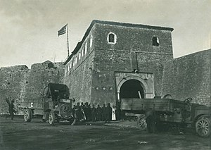
Castle of Bouka
Ottoman fortification in Preveza, Greece
Distance: Approx. 611 meters
Latitude and longitude: 38.95113,20.7561
The castle of Bouka (Greek: Κάστρο της Μπούκας, from the Italian word bocca) was the first major Ottoman fortification of Preveza, in northwestern Greece. It was constructed by the Ottomans in 1478, in order to control the straits of the Ambracian Gulf. In 1701, the Venetians blew the castle up before they handed Preveza over to the Ottomans, according to the terms of the Treaty of Karlowitz.

St. George's Castle, Preveza
Distance: Approx. 308 meters
Latitude and longitude: 38.94861111,20.75
St. George's Castle (Greek: Κάστρο Αγίου Γεωργίου, romanized: Kastro Agiou Georgiou; Turkish: Yeni kale, or Hizir kalesi) is an Ottoman fortification located in the city of Preveza, northwestern Greece. It was built in 1807, during the rule of Ali Pasha of Ioannina over the region (1806-1820), and it was constructed on plans drawn by the French engineer Frédéric François Guillaume de Vaudoncourt (1772-1845).
Castle of Saint Andrew
Fortress in Preveza, Greece
Distance: Approx. 1561 meters
Latitude and longitude: 38.9605,20.7533
The Castle of Saint Andrew (Greek: κάστρο του Αγίου Ανδρέα) is a fortress in Preveza, Greece. First constructed by the Ottoman Empire in the early 1700s, it was expanded under Venetian rule in 1718–1797 and again under the autonomous regime of Ali Pasha of Yanina in 1807–1808 to become the largest of the several fortifications in the Preveza area.
Weather in this IP's area
clear sky
16 Celsius
16 Celsius
16 Celsius
19 Celsius
1019 hPa
72 %
1019 hPa
1019 hPa
10000 meters
07:49:29
18:54:22