Country:
 Greece
Region:
City:
Latitude and Longitude:
Time Zone:
Postal Code:
IP information under different IP Channel
ip-api
Country
Region
City
ASN
Time Zone
ISP
Blacklist
Proxy
Latitude
Longitude
Postal
Route
IPinfo
Country
Region
City
ASN
Time Zone
ISP
Blacklist
Proxy
Latitude
Longitude
Postal
Route
MaxMind
Country
Region
City
ASN
Time Zone
ISP
Blacklist
Proxy
Latitude
Longitude
Postal
Route
Luminati
Country
GRRegion
d
City
filippiada
ASN
Time Zone
Europe/Athens
ISP
OTEnet S\.A\.
Latitude
Longitude
Postal
db-ip
Country
Region
City
ASN
Time Zone
ISP
Blacklist
Proxy
Latitude
Longitude
Postal
Route
ipdata
Country
Region
City
ASN
Time Zone
ISP
Blacklist
Proxy
Latitude
Longitude
Postal
Route
Popular places and events near this IP address
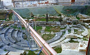
Ambracia
Ancient city in Greece
Distance: Approx. 465 meters
Latitude and longitude: 39.158,20.987
Ambracia (; Greek: Ἀμβρακία, occasionally Ἀμπρακία, Ampracia) was a city of ancient Greece on the site of modern Arta. It was founded by the Corinthians in 625 BC and was situated about 11 km (7 mi) from the Ambracian Gulf, on a bend of the navigable river Arachthos (or Aratthus), in the midst of a fertile wooded plain.

Arta, Greece
Municipality in Greece
Distance: Approx. 821 meters
Latitude and longitude: 39.165,20.9875
Arta (Greek: Άρτα) is a city in northwestern Greece and capital of the regional unit of Arta, which is part of Epirus region. The city was known in ancient times as Ambracia (Ancient Greek: Ἀμβρακία). Arta is known for the medieval bridge over the Arachthos River, as well as for its ancient sites from the era of Pyrrhus of Epirus and its well-preserved 13th-century castle.
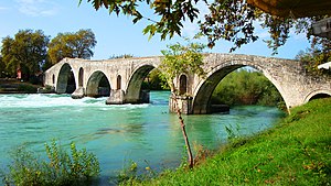
Bridge of Arta
Bridge in Arta, Greece
Distance: Approx. 1029 meters
Latitude and longitude: 39.15166667,20.97472222
The Bridge of Arta (Greek: Γεφύρι της Άρτας) is a stone bridge that crosses the Arachthos river (Άραχθος) in the west of the city of Arta (Άρτα) in northwestern Greece. It has been rebuilt many times over the centuries, starting with Roman or perhaps older foundations; the current bridge is probably a 17th-century Ottoman construction. The folk ballad "The Bridge of Arta" tells a story of human sacrifice during its building.
Vlacherna
Municipal unit in Greece
Distance: Approx. 1782 meters
Latitude and longitude: 39.16666667,21
Vlacherna (Greek: Βλαχέρνα) is a village and a former municipality in the Arta regional unit, Epirus, Greece. Since the 2011 local government reform it is part of the municipality Arta, of which it is a municipal unit. The municipal unit has an area of 76.142 km2.
Peta, Greece
Municipal unit in Greece
Distance: Approx. 4527 meters
Latitude and longitude: 39.16666667,21.03333333
Peta (Greek: Πέτα) is a town and a former municipality in the Arta regional unit, Epirus, northwestern Greece. Since the 2011 local government reform, it is part of the municipality of Nikolaos Skoufas, of which it is the seat and a municipal unit. The municipal unit has an area of 105.571 km2.

Battle of Peta
1822 battle of the war of Greek independence
Distance: Approx. 4260 meters
Latitude and longitude: 39.1672798,21.0300179
The Battle of Peta or Battle of Petta was fought between the Greeks (with Philhellenes) led by Alexandros Mavrokordatos with Markos Botsaris and the Ottomans led by Omer Vrioni on 16 July 1822 (4 July Julian calendar). The conflict occurred on a hillside near the village of Peta in Epirus.
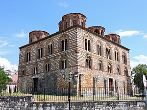
Church of the Parigoritissa
Distance: Approx. 148 meters
Latitude and longitude: 39.1589,20.9835
The Church of the Parigoritissa or Paregoretissa (Greek: Παναγία ἠ Παρηγορήτισσα, lit. 'Panagia of Consolation') is the 13th-century Byzantine metropolitan church of the Greek city of Arta. Part of the building used to house the Archaeological Collection of Arta.

Archaeological Museum of Arta
Archaeological museum in Epirus, Greece.
Distance: Approx. 1056 meters
Latitude and longitude: 39.15,20.97833333
The Archaeological Museum of Arta is a museum in Arta, Greece. It was established in 1973 as the Archaeological collection of Arta, and used to be housed in the 13th-century Paregoretissa church. The collection has now been moved to a brand new, purpose-built museum building which opened in 2009.

Feyzullah Mosque
Historical mosque in Arta, Greece
Distance: Approx. 410 meters
Latitude and longitude: 39.16277778,20.98194444
The Feyzullah Mosque (Greek: Φεϋζούλ Τζαμί; Turkish: Feyzullah Camii, "Mosque of Feyzullah") is a historical Ottoman-era mosque in the town of Arta, Epirus, Greece.

Faik Pasha Mosque
Historical mosque in Arta, Greece
Distance: Approx. 1081 meters
Latitude and longitude: 39.16583333,20.97277778
Faik Pasha Mosque (Turkish: Faik Paşa Camii, Greek: Τζαμί Φαΐκ Πασά), also known locally as the Imaret of Arta (Ιμαρέτ της Άρτας), is a historical Ottoman building located in the town of Arta, Epirus, in Greece. Named after the Ottoman conqueror of the city in 1449, the mosque formed a complex including baths, an imaret and a madrasa. It is one of the two surviving mosques in Arta, the other being the Feyzullah Mosque.
Sultan Mehmed Mosque, Arta
Mosque in Arta, Greece
Distance: Approx. 905 meters
Latitude and longitude: 39.16555556,20.98816667
The Sultan Mehmed Mosque (Greek: Σουλτάν Μεχμέτ Τζαμί, Turkish: Sultan Mehmet Camii), also known as the Suleyman Agha Mosque (Greek: Σουλεϊμάν Αγά Τζαμί, Turkish: Süleyman Ağa Camii), was an Ottoman mosque in the town of Arta, Greece, built within the Castle of Arta. It was one of the eight mosques of the town, and one of the six that no longer exist.
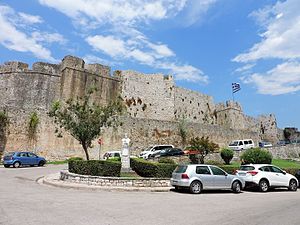
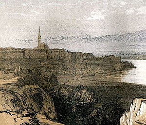
Castle of Arta
Medieval fortification in Arta, Greece
Distance: Approx. 750 meters
Latitude and longitude: 39.16474194,20.98654194
The Castle of Arta (Greek: Κάστρο της Άρτας) is a medieval fortification in the city of Arta in western Greece.
Weather in this IP's area
scattered clouds
20 Celsius
20 Celsius
20 Celsius
20 Celsius
1013 hPa
73 %
1013 hPa
1008 hPa
10000 meters
1.62 m/s
1.76 m/s
37 degree
38 %
07:19:24
19:41:45