Country:
 Greece
Region:
City:
Latitude and Longitude:
Time Zone:
Postal Code:
IP information under different IP Channel
ip-api
Country
Region
City
ASN
Time Zone
ISP
Blacklist
Proxy
Latitude
Longitude
Postal
Route
IPinfo
Country
Region
City
ASN
Time Zone
ISP
Blacklist
Proxy
Latitude
Longitude
Postal
Route
MaxMind
Country
Region
City
ASN
Time Zone
ISP
Blacklist
Proxy
Latitude
Longitude
Postal
Route
Luminati
Country
GRRegion
a
City
xanthi
ASN
Time Zone
Europe/Athens
ISP
OTEnet S\.A\.
Latitude
Longitude
Postal
db-ip
Country
Region
City
ASN
Time Zone
ISP
Blacklist
Proxy
Latitude
Longitude
Postal
Route
ipdata
Country
Region
City
ASN
Time Zone
ISP
Blacklist
Proxy
Latitude
Longitude
Postal
Route
Popular places and events near this IP address
Xanthi
Municipality in Thrace, Greece
Distance: Approx. 1204 meters
Latitude and longitude: 41.13333333,24.88333333
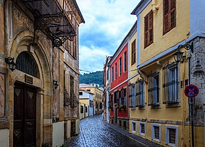
Xanthi is a city in the region of Western Thrace, northeastern Greece. It is the capital of the Xanthi regional unit of the region of East Macedonia and Thrace. Amphitheatrically built on the foot of Rhodope mountain chain, the city is divided by the Kosynthos River, into the west part, where the old and the modern town are located, and the east part that boasts a rich natural environment.

Xanthi (regional unit)
Regional unit in Greece
Distance: Approx. 3841 meters
Latitude and longitude: 41.16666667,24.91666667
Xanthi (pronounced [ˈksanθi], Greek: Περιφερειακή ενότητα Ξάνθης) is one of the regional units of Greece. It is part of the Region of East Macedonia and Thrace. The capital is Xanthi.
Xanthi Ground
Football stadium in Xanthi, Greece.
Distance: Approx. 997 meters
Latitude and longitude: 41.14388889,24.89388889
A.O. Xanthi Ground is a football stadium in Xanthi, Greece. It hosted Skoda Xanthi until the team moved to the Skoda Xanthi Arena in 2004. It is currently used by Orfeas Xanthi who play in the Gamma Ethniki.
Chrysa (Xanthi)
Distance: Approx. 2938 meters
Latitude and longitude: 41.13333333,24.85
Chrysa (Greek: Χρύσα) is the western quarter of the town Xanthi, in northern Greece. It was originally built as a settlement for refugees after the Greco-Turkish War (1919–1922).
Evmoiro
Community in Xanthi, Greece
Distance: Approx. 4221 meters
Latitude and longitude: 41.11,24.86
Evmoiro (Greek: Εύμοιρο) is a community in the municipality of Xanthi, northern Greece. It consists of the settlements Evmoiro, Kallithea, Lamprino, Lefki, Nea Morsini, Palaia Morsini and Petrochori (Turkish: Kayalar).
Kimmeria
Community in Greece
Distance: Approx. 4353 meters
Latitude and longitude: 41.15,24.93333333
Kimmeria (Greek: Κιμμέρια, previously known as Kiougioukki, Turkish: Koyunköy) is a community in the municipality Xanthi in the Xanthi regional unit of Greece. It is located 740 kilometers from Athens, 233 kilometers from Thessalonica, and 5 kilometers east of Xanthi. The community consists of the settlements Kimmeria, Alikochori, Anthiro, Askyra, Gialistero, Eranos, Ketiki, Livadi, Panepistimioupoli (Campus of Democritus University of Thrace), Pelekito, Porta, Prioni and Ydrochori, many of which are deserted.
Siroko
Settlement in Greece
Distance: Approx. 4052 meters
Latitude and longitude: 41.18,24.89
Siroko (Greek: Σιρόκο, Bulgarian: Широка поляна) is a settlement in the Xanthi regional unit of Greece located south of Sminthi. It is part of the community of Myki. In 2021, the population of the settlement was 112 inhabitants.
Philippos Amiridis Indoor Hall
Distance: Approx. 1642 meters
Latitude and longitude: 41.1307,24.8902
Xanthi Arena, AKA Philippos Amiridis Arena is an indoor sporting arena that is located in the city of Xanthi, in the region of Western Thrace, Greece. The arena can be used for both basketball and volleyball games. Its capacity is 3,957 seats.
Xanthi railway station
Railway Station
Distance: Approx. 2415 meters
Latitude and longitude: 41.1239,24.8925
Xanthi railway station (Greek: Σιδηροδρομικός Σταθμός Ξάνθης, romanized: Sidirodromikós stathmós Xànthi) is a railway station that servers the city of Xanthi, in Xanthi in East Macedonia and Thrace, Greece. The station is located 3 kilometres (1.9 mi) southwest of the city centre, but still within the city limits. The station (as of 2019) is staffed, but only at peak times, but has waiting rooms and a taxi rank.
Xanthi Carnival
Distance: Approx. 739 meters
Latitude and longitude: 41.139189,24.887929
Xanthi Carnival (or Carnival of Xanthi; Greek: Ξανθιώτικο Καρναβάλι) and Thracian Folk Festival is the biggest event of its kind in northern Greece and the second biggest in Greece, following the Patras Carnival. Ιt was founded in 1966, in a formal way. The event is held annually under the auspices of the Cultural Center of the Municipality of Xanthi.
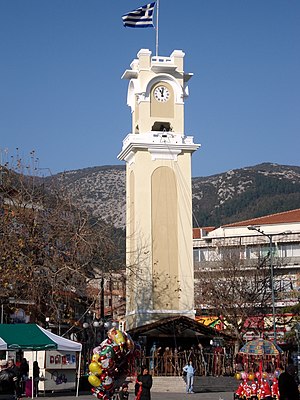
Clock tower of Xanthi
Monument in Xanthi, Greece
Distance: Approx. 671 meters
Latitude and longitude: 41.13972222,24.8875
The Clock tower of Xanthi (Greek: Πύργος του Ωρολογίου) is an Ottoman-era monument located in the central square of the town of Xanthi, in northern Greece (region of Western Thrace).

Hamidiye Bridge
Bridge in Xanthi, Greece
Distance: Approx. 2369 meters
Latitude and longitude: 41.16527778,24.87916667
The Hamidiye Bridge (Greek: Γέφυρα Χαμιδιέ, Turkish: Hamidiye) is a four-arch Ottoman bridge in Western Thrace, Greece, built in the early twentieth century.
Weather in this IP's area
clear sky
19 Celsius
19 Celsius
19 Celsius
21 Celsius
1013 hPa
74 %
1013 hPa
993 hPa
10000 meters
2.95 m/s
3.42 m/s
7 degree
1 %
07:03:10
19:26:48