Country:
 Greece
Region:
City:
Latitude and Longitude:
Time Zone:
Postal Code:
IP information under different IP Channel
ip-api
Country
Region
City
ASN
Time Zone
ISP
Blacklist
Proxy
Latitude
Longitude
Postal
Route
IPinfo
Country
Region
City
ASN
Time Zone
ISP
Blacklist
Proxy
Latitude
Longitude
Postal
Route
MaxMind
Country
Region
City
ASN
Time Zone
ISP
Blacklist
Proxy
Latitude
Longitude
Postal
Route
Luminati
Country
GRRegion
g
City
aitoliko
ASN
Time Zone
Europe/Athens
ISP
OTEnet S\.A\.
Latitude
Longitude
Postal
db-ip
Country
Region
City
ASN
Time Zone
ISP
Blacklist
Proxy
Latitude
Longitude
Postal
Route
ipdata
Country
Region
City
ASN
Time Zone
ISP
Blacklist
Proxy
Latitude
Longitude
Postal
Route
Popular places and events near this IP address

Aitoliko
Municipal unit in Greece
Distance: Approx. 2143 meters
Latitude and longitude: 38.45,21.36666667
Aitoliko (Greek: Αιτωλικό) is a town and a former municipality in Aetolia-Acarnania, West Greece, Greece. Since the 2011 local government reform, it is part of the municipality Messolonghi, of which it is a municipal unit. The municipal unit has an area of 129,305 m2.

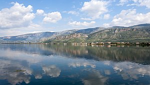
Missolonghi Lagoon
Distance: Approx. 9622 meters
Latitude and longitude: 38.35,21.3667
The Missolonghi Lagoon (Greek: Λιμνοθάλασσα Μεσολογγίου, Limnothalassa Mesolongiou) is a shallow lagoon located in the south of Aetolia-Acarnania, Western Greece. It is connected with the Gulf of Patras, a bay of the Ionian Sea. It has a triangular shape and its width varies between approximately 15 to 20 km.
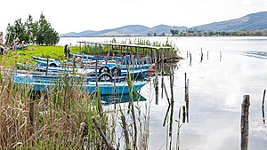
Aitoliko Lagoon
Lake in Greece
Distance: Approx. 4236 meters
Latitude and longitude: 38.47,21.33
The Aitoliko Lagoon (Greek: Λιμνοθάλασσα Αιτωλικού Limnothalassa Aitolikou) is a lagoon located in the south of Aetolia-Acarnania, Greece. It is separated from the larger Missolonghi Lagoon (a bay of the Gulf of Patras) to the south by the island of Aitoliko, but together they form the Missolonghi–Aitoliko Lagoons complex. Its maximum depth is 28 metres.
Missolonghi–Aitoliko Lagoons
Distance: Approx. 5438 meters
Latitude and longitude: 38.387,21.358
The Missolonghi-Aitoliko lagoons complex is located in the north part of the Gulf of Patras in the central west coast of Greece. It is one of the most important Mediterranean lagoons. It is a shallow area of 150 km2, extended between the Acheloos and Evinos rivers.

Pleuron (Aetolia)
Ancient Greek city
Distance: Approx. 5675 meters
Latitude and longitude: 38.414413,21.409739
Pleuron (Ancient Greek: Πλευρών, gen.: Πλευρῶνος; Greek: Πλευρώνα, Plevrona or Ασφακοβούνι, Asfakovouni) was a city in ancient Aetolia, Greece. The name refers to two settlements, the older of which was at the foot of Mount Curium between the river Acheloos and the river Evenos, and was mentioned by Homer in the Catalogue of Ships in the Iliad. The territory of Pleuron was called Pleuronia.

Second siege of Missolonghi
1823 siege
Distance: Approx. 2087 meters
Latitude and longitude: 38.4472,21.3692
The Second Siege of Missolonghi was the second attempt by Ottoman forces to capture the strategically located port town of Missolonghi during the third year of the Greek War of Independence (1823). The second siege is usually ignored however, and the name is often applied to the greater siege of 1825–1826.

Aitoliko railway station
Greek railway station
Distance: Approx. 1249 meters
Latitude and longitude: 38.43805556,21.36444444
Aitoliko railway station (Greek: Σιδηροδρομικός Σταθμός Αιτωλικού, Sidirodromikos Stathmos Etolikou) was a railway station in the town of Aitoliko in Aetolia-Acarnania, Greece.
Katochi
Community in Greece
Distance: Approx. 9615 meters
Latitude and longitude: 38.4,21.25
Katochi (Greek: Κατοχή) is a village and a community in the municipal unit of Oiniades in Aetolia-Acarnania, West Greece, Greece. In 2021, it had a population of 2,514.
Pylene
Distance: Approx. 4713 meters
Latitude and longitude: 38.474,21.373
Pylene (Ancient Greek: Πυλήνη) was a town of ancient Aetolia, between the Acheolous and the Evenus, mentioned in Homer's Catalogue of Ships in the Iliad, is placed by Pliny the Elder on the Corinthian Gulf. It would therefore seem to have existed in later times. Strabo says that the Aeolians who took Pylene afterwards removed higher up into the country and founded Proschium.
Paeanium
Distance: Approx. 6365 meters
Latitude and longitude: 38.43718,21.27754
Paeanium or Paianion (Ancient Greek: Παιάνιον) was a town in ancient Aetolia, near the Achelous River, a little south of Ithoria, and north of Oeniadae, which was on the other side of the river. It was only 7 stadia in circumference, and was destroyed by Philip V of Macedon in 219 BCE. Paeanium was perhaps rebuilt, and may be the same town as Phana (φάνα), which was taken by the Achaeans, and which we learn from the narrative in Pausanias was near the sea. Stephanus of Byzantium mentions Phana as a town of Italy; but for Πόλις Ἰταλίας ('city of Italy'), we ought probably to read Πόλις Αἰτωλίας ('city of Aetolia').
Proschium
Distance: Approx. 7428 meters
Latitude and longitude: 38.444,21.435
Proschium or Proschion (Ancient Greek: Πρόσχιον) was a town of ancient Aetolia, between the Achelous and the Evenus. It is said to have been founded by the Aeolians when they were removed from the Homeric Pylene higher up into the country. Proschium also laid claim to high antiquity, since it possessed a shrine said to have been dedicated by Heracles to his cupbearer Cyathus, whom he had unintentionally slain.
Ithoria
Distance: Approx. 8105 meters
Latitude and longitude: 38.488717,21.287041
Ithoria (Ancient Greek: Ἰθωρία) was a town of ancient Aetolia, near the Achelous River, and a short distance south of Conope. It was situated at the entrance of a pass, and was strongly fortified both by nature and by art. It was taken by Philip V of Macedon and levelled to the ground in 219 BCE. Its site is located near the modern Agios Ilias.
Weather in this IP's area
clear sky
18 Celsius
18 Celsius
18 Celsius
22 Celsius
1012 hPa
65 %
1012 hPa
1012 hPa
10000 meters
1.6 m/s
1.72 m/s
16 degree
2 %
07:18:09
19:40:04