Country:
 Greece
Region:
City:
Latitude and Longitude:
Time Zone:
Postal Code:
IP information under different IP Channel
ip-api
Country
Region
City
ASN
Time Zone
ISP
Blacklist
Proxy
Latitude
Longitude
Postal
Route
IPinfo
Country
Region
City
ASN
Time Zone
ISP
Blacklist
Proxy
Latitude
Longitude
Postal
Route
MaxMind
Country
Region
City
ASN
Time Zone
ISP
Blacklist
Proxy
Latitude
Longitude
Postal
Route
Luminati
Country
GRRegion
a
City
alexandroupoli
ASN
Time Zone
Europe/Athens
ISP
OTEnet S\.A\.
Latitude
Longitude
Postal
db-ip
Country
Region
City
ASN
Time Zone
ISP
Blacklist
Proxy
Latitude
Longitude
Postal
Route
ipdata
Country
Region
City
ASN
Time Zone
ISP
Blacklist
Proxy
Latitude
Longitude
Postal
Route
Popular places and events near this IP address

Alexandroupolis
City in northeast Greece
Distance: Approx. 1173 meters
Latitude and longitude: 40.85,25.86666667
Alexandroupolis (Greek: Αλεξανδρούπολη, pronounced [aleksanˈðrupoli]) or Alexandroupoli is a city in Greece and the capital of the Evros regional unit. It is the largest city in Greek Thrace and the region of Eastern Macedonia and Thrace, with a population of 71,751, and is an important port and commercial center for northeastern Greece. The city was first settled by the Ottoman Empire in the 19th century and grew into the fishing village Dedeağaç.

Alexandroupoli Airport
Airport in Apalos, Greece
Distance: Approx. 7149 meters
Latitude and longitude: 40.85586944,25.95626389
Alexandroupoli Airport "Dimokritos" or "Democritus" (Greek: Κρατικός Αερολιμένας Αλεξανδρούπολης "Δημόκριτος", Kratikós Aeroliménas Alexandrúpolis "Dimókritos") (IATA: AXD, ICAO: LGAL) is an airport 7 km east of Alexandroupolis in northeastern Greece on main national road E90. It is located near the village of Apalos, which belongs to the municipality of Alexandroupoli. The airport was built in 1944.
Antheia, Evros
Community in Greece
Distance: Approx. 9666 meters
Latitude and longitude: 40.86666667,25.98333333
Anthia (Greek: Άνθεια) is a village and a community in the southern part of the Evros regional unit in Greece. Antheia is located near the old Greek National Road 2 between Alexandroupoli and Feres. It is 10 km east of the centre of Alexandroupoli.
Sale (Thrace)
Distance: Approx. 434 meters
Latitude and longitude: 40.844659,25.875051
Sale (Greek: Σάλη, Sálē) was a Greek city located on the south coast of ancient Thrace, near the west mouth of the Hebrus, and nearly equidistant from Zone and Doriscus, thus between the river Nestos and the Hebrus. Herodotus tells us that it was founded as a colony from Samothrace. While Livy wrote that during his time the city belonged to the Maroneia.
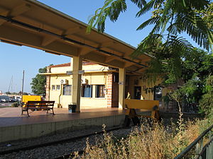
Alexandroupolis railway station
Railway station in Greece
Distance: Approx. 664 meters
Latitude and longitude: 40.8451,25.8793
Alexandroupolis railway station or Alexandroupolid Port railway station (Greek: Σιδηροδρομικός Σταθμός Λιμένα Αλεξανδρούπολης, romanized: Sidirodromikos Stathmos Limena Alexandroupolis) is the main railway station of Alexandroupolis in Eastern Macedonia and Thrace, Greece. Built-in the 1950s to combine the city's then-two stations, the current station is located in the city centre and acts as an interchange for services to Ormenio and Thessaloniki. Trains approaching from Thessaloniki must reverse for a few hundred meters to reach the station.
Amfitriti
Place in Greece
Distance: Approx. 6748 meters
Latitude and longitude: 40.89111111,25.91861111
Amfitriti is a village in Evros regional unit, East Macedonia and Thrace, Greece. It is part of the community of Alexandroupoli.

Alexandroupolis Mosque
Ottoman mosque in Alexandroupolis, Greece
Distance: Approx. 912 meters
Latitude and longitude: 40.84688889,25.88108333
The Mosque of Alexandroupolis (Greek: Τζαμί Αλεξανδρούπολης, Turkish: Dedeağaç Camii) is an Ottoman-era mosque in the town of Alexandroupolis, Western Thrace, in Greece. Like most mosques in Thrace, it is open for worship and serves the small Muslim community of the town. The entrance to the mosque is in the north side of Kassandras Street.
Weather in this IP's area
clear sky
18 Celsius
18 Celsius
18 Celsius
20 Celsius
1012 hPa
77 %
1012 hPa
1012 hPa
10000 meters
06:59:18
19:22:44