Country:
 Greece
Region:
City:
Latitude and Longitude:
Time Zone:
Postal Code:
IP information under different IP Channel
ip-api
Country
Region
City
ASN
Time Zone
ISP
Blacklist
Proxy
Latitude
Longitude
Postal
Route
IPinfo
Country
Region
City
ASN
Time Zone
ISP
Blacklist
Proxy
Latitude
Longitude
Postal
Route
MaxMind
Country
Region
City
ASN
Time Zone
ISP
Blacklist
Proxy
Latitude
Longitude
Postal
Route
Luminati
Country
GRRegion
l
City
ermoupoli
ASN
Time Zone
Europe/Athens
ISP
OTEnet S\.A\.
Latitude
Longitude
Postal
db-ip
Country
Region
City
ASN
Time Zone
ISP
Blacklist
Proxy
Latitude
Longitude
Postal
Route
ipdata
Country
Region
City
ASN
Time Zone
ISP
Blacklist
Proxy
Latitude
Longitude
Postal
Route
Popular places and events near this IP address

Syros
Regional unit and municipality in Greece
Distance: Approx. 2161 meters
Latitude and longitude: 37.43333333,24.91666667
Syros (Greek: Σύρος [ˈsiros]), also known as Siros or Syra, is a Greek island in the Cyclades, in the Aegean Sea. It is 78 nautical miles (144 km) south-east of Athens. The area of the island is 83.6 km2 (32 sq mi) and at the 2021 census it had 21,124 inhabitants.

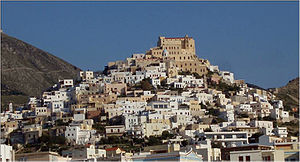
Ermoupoli
Municipal unit in Greece
Distance: Approx. 2161 meters
Latitude and longitude: 37.43333333,24.91666667
Ermoupoli (Greek: Ερμούπολη), also known by the formal older name Ermoupolis or Hermoupolis (Greek: Ἑρμούπολις < Ἑρμοῦ πόλις "Town of Hermes"), is a town and former municipality on the island of Syros, in the Cyclades, Greece. Since the 2011 local government reform, it is part of the municipality Syros-Ermoupoli, of which it is the seat and a municipal unit. It is also the capital of the South Aegean region.
Ano Syros
Municipal unit in Greece
Distance: Approx. 2225 meters
Latitude and longitude: 37.46666667,24.93333333
Ano Syros (Greek: Άνω Σύρος, “Upper Syros”) is a town and a former municipality on the island of Syros, in the Cyclades, Greece. Since the 2011 local government reform it is part of the municipality Syros-Ermoupoli, of which it is a municipal unit. The municipal unit includes the uninhabited islands Gyaros (lying to the northwest of Syros) and Varvaroúsa.

Roman Catholic Diocese of Syros
Roman Catholic diocese in Greece
Distance: Approx. 496 meters
Latitude and longitude: 37.4511,24.9353
The Diocese of Syros and Milos (Latin: Dioecesis Syrensis et Milensis) is a Latin Church diocese of the Catholic Church located in the cities of Syros and Milos in the ecclesiastical province of Naxos, Andros, Tinos and Mykonos in Greece.

St. George's Cathedral, Ano Syros
Distance: Approx. 467 meters
Latitude and longitude: 37.45083333,24.93527778
Saint George's Cathedral is the cathedral of the Roman Catholic Diocese of Syros and Milos. It is located in the town of Ano Syros, on the island of Syros, Greece.

Miaouli Square
Open square in Ermoupolis, Greece
Distance: Approx. 775 meters
Latitude and longitude: 37.4447,24.9428
Miaouli Square (Greek: Πλατεία Μιαούλη) is a square in the city of Ermoupolis, Syros island in Greece.
Chalandriani
Distance: Approx. 4095 meters
Latitude and longitude: 37.4834722,24.9332831
Chalandriani (Greek: Χαλανδριανή) is a major early Bronze Age cemetery on the island of Syros in Greece, dated to the Early Cycladic II period (Keros-Syros culture, 2600–2300 BC). The fortified prehistoric settlement of Kastri is located north of Chalandriani. Chalandriani was first excavated by the Greek classical archaeologist Christos Tsountas in 1898.

Azolimnos Syros
Settlement in Greece
Distance: Approx. 4820 meters
Latitude and longitude: 37.41027778,24.96388889
Azolimnos Syros is a village on the southeast coast of the Greek island of Syros. Syros belongs to the Cyclades island group. Azolimnos is 6 km from the Syros capital, Ermoupoli.
Chrousa
Community in Greece
Distance: Approx. 5499 meters
Latitude and longitude: 37.398,24.924
Chrousa (Greek: Χρούσα, also: Χρούσσα - Chroussa) is a settlement on the south side of the island of Syros and is 8.5 km from the island capital Ermoupoli. In Chrousa we find traditional newly built houses, villas and old majestic mansions, while in relation to various islands of the Cyclades, where the landscapes are dry and deserted, there is quite dense vegetation in the specific village. A beautiful pine tree forest embraces the village, a favorite destination of migratory birds unfortunately threatened by the unconscious hunters of the island.

Apollon Theater, Syros
Building in Ermoupolis, South Aegean, Greece
Distance: Approx. 829 meters
Latitude and longitude: 37.44527778,24.94361111
The Apollo Theater, also known as the Municipal Theater "Apollo", is a theater located in Ermoupolis on Syros in the Cyclades. A cultural icon of the city, it was built in 1862–1864 to the designs of the Italian architect Pietro Sampò and opened on 20 April 1864.
Archaeological Museum of Syros
Archaeological Museum in Syros, Greece
Distance: Approx. 726 meters
Latitude and longitude: 37.4451411,24.9423797
The Archaeological Museum Of Syros is located in Ermoupoli in Syros.
Galessus
Distance: Approx. 6034 meters
Latitude and longitude: 37.42,24.875
Galessus or Galessos (Ancient Greek: Γαλήσσος) was an ancient town on the island of Syros. Its site is located near Galissas.
Weather in this IP's area
clear sky
18 Celsius
17 Celsius
17 Celsius
18 Celsius
1020 hPa
57 %
1020 hPa
1013 hPa
10000 meters
9.26 m/s
20 degree
07:31:09
18:39:14