94.42.195.155 - IP Lookup: Free IP Address Lookup, Postal Code Lookup, IP Location Lookup, IP ASN, Public IP
Country:
 Poland
Region:
City:
Location:
Time Zone:
Postal Code:
ISP:
ASN:
language:
User-Agent:
Proxy IP:
Blacklist:
IP information under different IP Channel
ip-api
Country
Region
City
ASN
Time Zone
ISP
Blacklist
Proxy
Latitude
Longitude
Postal
Route
db-ip
Country
Region
City
ASN
Time Zone
ISP
Blacklist
Proxy
Latitude
Longitude
Postal
Route
IPinfo
Country
Region
City
ASN
Time Zone
ISP
Blacklist
Proxy
Latitude
Longitude
Postal
Route
IP2Location
94.42.195.155Country
plRegion
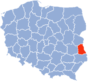
lubelskie
City
chelm
Time Zone
Europe/Warsaw
ISP
Language
User-Agent
Latitude
Longitude
Postal
ipdata
Country
Region
City
ASN
Time Zone
ISP
Blacklist
Proxy
Latitude
Longitude
Postal
Route
Popular places and events near this IP address
Chełm Voivodeship
Former administrative division of Poland
Distance: Approx. 779 meters
Latitude and longitude: 51.136457,23.475093
Chełm Voivodeship (Polish: województwo chełmskie) was a unit of administrative division and local government in Poland in years 1975–1998, superseded by Lublin Voivodeship. Its capital city was Chełm.

Chełm
City in Lublin Voivodeship, Poland
Distance: Approx. 1285 meters
Latitude and longitude: 51.13222222,23.47777778
Chełm (Polish: [xɛwm] ; Ukrainian: Холм, romanized: Kholm; German: Cholm; Yiddish: כעלם, romanized: Khelm) is a city in southeastern Poland with 60,231 inhabitants as of December 2021. It is located to the south-east of Lublin, north of Zamość and south of Biała Podlaska, some 25 kilometres (16 miles) from the border with Ukraine. Chełm used to be the capital of the Chełm Voivodeship until it became part of the Lublin Voivodeship in 1999.

Chełm County
County in Lublin Voivodeship, Poland
Distance: Approx. 1123 meters
Latitude and longitude: 51.15,23.48333333
Chełm County (Polish: powiat chełmski) is a unit of territorial administration and local government (powiat) in Lublin Voivodeship, eastern Poland, on the border with Ukraine. It was established on January 1, 1999, as a result of the Polish local government reforms passed in 1998. Its administrative seat is the city of Chełm, although the city is not part of the county (it constitutes a separate city county).

Chełm Land
Historic region of Poland
Distance: Approx. 779 meters
Latitude and longitude: 51.136457,23.475093
Chełm Land was a region of the Kingdom of Poland and later of the Polish–Lithuanian Commonwealth (1569–1795). Today, the region is situated in the modern states of Poland, Ukraine, and Belarus. As an exclave of the Ruthenian Voivodeship, it was separated from the main part of the voivodeship by the voivodeship of Bełz.

Chełm Chalk Tunnels
Chalk mine in Poland
Distance: Approx. 1124 meters
Latitude and longitude: 51.133004,23.471298
The Chełm Chalk Tunnels (in Polish Chełmskie podziemia kredowe) are a system of tunnels dug into the chalk under the city of Chełm in eastern Poland. The tunnelling began in the Middle Ages for chalk mining and was discontinued in the 19th century. The tunnels also served Chełm's inhabitants as shelters during raids, wars and pillage.

Basilica of the Birth of the Virgin Mary, Chełm
Distance: Approx. 1435 meters
Latitude and longitude: 51.13147222,23.48047222
The Basilica of the Birth of the Virgin Mary (Polish: Bazylika Narodzenia Najświętszej Maryi Panny, Ukrainian: Собор Різдва Пресвятої Богородиці) is a church and monastery complex of the Roman Catholic Church located in the Polish city of Chełm. The church and the courtyard of the basilica stand in the centre of Chełm on Chełm Hill (also called Cathedral Hill or Castle Hill). Over its history, the church has been Orthodox, Uniate and Roman Catholic.

Horodyszcze-Kolonia
Village in Lublin Voivodeship, Poland
Distance: Approx. 3654 meters
Latitude and longitude: 51.16722222,23.43611111
Horodyszcze-Kolonia [xɔrɔˈdɨʂt͡ʂɛ kɔˈlɔɲa] is a village in the administrative district of Gmina Chełm, within Chełm County, Lublin Voivodeship, in eastern Poland.
Koza-Gotówka
Village in Lublin Voivodeship, Poland
Distance: Approx. 3240 meters
Latitude and longitude: 51.15,23.51666667
Koza-Gotówka [ˈkɔza ɡɔˈtufka] is a village in the administrative district of Gmina Chełm, within Chełm County, Lublin Voivodeship, in eastern Poland. It lies approximately 8 kilometres (5 mi) north-east of Pokrówka, 3 km (2 mi) east of Chełm, and 67 km (42 mi) east of the regional capital Lublin.
Okszów
Village in Lublin Voivodeship, Poland
Distance: Approx. 3289 meters
Latitude and longitude: 51.16666667,23.5
Okszów [ˈɔkʂuf] is a village in the administrative district of Gmina Chełm, within Chełm County, Lublin Voivodeship, in eastern Poland.
Okszów-Kolonia
Village in Lublin Voivodeship, Poland
Distance: Approx. 2735 meters
Latitude and longitude: 51.1575,23.50333333
Okszów-Kolonia [ˈɔkʂuf kɔˈlɔɲa] is a village in the administrative district of Gmina Chełm, within Chełm County, Lublin Voivodeship, in eastern Poland.
Stańków
Village in Lublin Voivodeship, Poland
Distance: Approx. 3270 meters
Latitude and longitude: 51.17222222,23.47777778
Stańków [ˈstaɲkuf] is a village in the administrative district of Gmina Chełm, within Chełm County, Lublin Voivodeship, in eastern Poland. Stańków used to be the family seat of the Czapski family.
Żółtańce-Kolonia
Village in Lublin Voivodeship, Poland
Distance: Approx. 3506 meters
Latitude and longitude: 51.11638889,23.445
Żółtańce-Kolonia [ʐuu̯ˈtaɲt͡sɛ kɔˈlɔɲa] is a village in the administrative district of Gmina Chełm, within Chełm County, Lublin Voivodeship, in eastern Poland.
Weather in this IP's area
clear sky
-3 Celsius
-9 Celsius
-3 Celsius
-3 Celsius
1042 hPa
72 %
1042 hPa
1016 hPa
10000 meters
5.96 m/s
12 m/s
111 degree
5 %