94.250.43.123 - IP Lookup: Free IP Address Lookup, Postal Code Lookup, IP Location Lookup, IP ASN, Public IP
Country:
Region:
City:
Location:
Time Zone:
Postal Code:
IP information under different IP Channel
ip-api
Country
Region
City
ASN
Time Zone
ISP
Blacklist
Proxy
Latitude
Longitude
Postal
Route
Luminati
Country
ASN
Time Zone
Europe/Sarajevo
ISP
Blicnet d.o.o. Banja Luka
Latitude
Longitude
Postal
IPinfo
Country
Region
City
ASN
Time Zone
ISP
Blacklist
Proxy
Latitude
Longitude
Postal
Route
IP2Location
94.250.43.123Country
Region
republika srpska
City
trebinje
Time Zone
Europe/Sarajevo
ISP
Language
User-Agent
Latitude
Longitude
Postal
db-ip
Country
Region
City
ASN
Time Zone
ISP
Blacklist
Proxy
Latitude
Longitude
Postal
Route
ipdata
Country
Region
City
ASN
Time Zone
ISP
Blacklist
Proxy
Latitude
Longitude
Postal
Route
Popular places and events near this IP address

Trebinje
City in Republika Srpska, Bosnia and Herzegovina
Distance: Approx. 156 meters
Latitude and longitude: 42.71194444,18.34611111
Trebinje (Serbian Cyrillic: Требиње, pronounced [trěːbiɲe]) is a city and municipality in Republika Srpska entity, Bosnia and Herzegovina. It is the southernmost city in Bosnia and Herzegovina and is situated on the banks of the Trebišnjica river in the region of East Herzegovina. As of 2013, it has a population of 31,433 inhabitants.

Travunia
Historical state
Distance: Approx. 2152 meters
Latitude and longitude: 42.7172547,18.3694839
Travunia (Serbo-Croatian: Travunija / Травунија; Greek: Τερβουνία, romanized: Tervounía; Ancient Greek: Τερβουνία, romanized: Terbounía; Latin: Tribunia) was a South Slavic medieval principality that was part of Medieval Serbia (850–1371), and later the Medieval Bosnia (1373–1482). The principality became hereditary in a number of noble houses, often kin to the ruling dynasty. The region came under Ottoman rule in 1482.

SAO Herzegovina
Distance: Approx. 156 meters
Latitude and longitude: 42.71194444,18.34611111
The SAO of Herzegovina (Serbian: Српска аутономна област Херцеговина, Srpska autonomna oblast Hercegovina) was a self-proclaimed Serbian Autonomous Oblast within today's Bosnia and Herzegovina. It was proclaimed by the Assembly of the Association of Municipalities of Bosnian Krajina in 1991 and was subsequently included into Republika Srpska. SAO Herzegovina was located in the geographical region of Herzegovina.

Roman Catholic Diocese of Trebinje-Mrkan
Catholic ecclesiastical territory
Distance: Approx. 133 meters
Latitude and longitude: 42.7109,18.3451
The Diocese of Trebinje-Mrkan (Latin: Diocesis Tribuniensis-Marcanensis) is a particular church of the Catholic Church in Bosnia and Herzegovina. Established in the 10th century, is the oldest Catholic diocese in Bosnia and Herzegovina. By the number of faithful, it is also the smallest.
Pridvorci, Trebinje
Village in Republika Srpska, Bosnia and Herzegovina
Distance: Approx. 2068 meters
Latitude and longitude: 42.69666667,18.32972222
Pridvorci (Serbian Cyrillic: Придворци) is a village in the municipality of Trebinje, Republika Srpska, Bosnia and Herzegovina.

Cathedral of the Birth of Mary, Trebinje
Church in Bosnia and Herzegovina
Distance: Approx. 88 meters
Latitude and longitude: 42.71111111,18.34416667
The Cathedral of the Birth of Mary or Trebinje Catholic Cathedral (Serbo-Croatian: Katedrala Male Gospe, Катедрала Мале Госпе) in Trebinje is one of four Roman Catholic cathedrals in Bosnia and Herzegovina. It is the seat of the Trebinje-Mrkan Bishopric. Petar Palić acts as bishop to the Trebinje-Mrkan Bishopric as well as the Mostar-Duvno Bishopric.

Hercegovačka Gračanica
Distance: Approx. 1278 meters
Latitude and longitude: 42.71055556,18.35972222
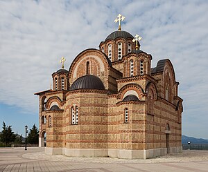
The Hercegovačka Gračanica Monastery (Serbian: Манастир Херцеговачка Грачаница, romanized: Manastir Hercegovačka Gračanica) is a Serbian Orthodox monastery located in Trebinje, in Bosnia and Herzegovina. Largely a copy of the Gračanica monastery in Kosovo, it was completed in 2000. The monastery is located above the city, on the historic Crkvina Hill, and is dedicated to the Virgin Mary.
Radio Trebinje
Bosnian radio station
Distance: Approx. 156 meters
Latitude and longitude: 42.71194444,18.34611111
Radio Trebinje or Радио Требиње is a Bosnian local public radio station, broadcasting from Trebinje, Bosnia and Herzegovina. It was launched on 29 November 1975 as first electronic media in eastern Herzegovina. In Yugoslavia and in SR Bosnia and Herzegovina, it was part of local/municipal Radio Sarajevo network affiliate.
Korona Radio 1
Bosnian radio station
Distance: Approx. 156 meters
Latitude and longitude: 42.71194444,18.34611111
Korona Radio 1 or Korona Radio is a Bosnian local commercial radio station, broadcasting from Trebinje, Bosnia and Herzegovina. This radio station broadcasts a variety of programs such as pop-rock music with local news. The owner of the radio station is the company Korona d.o.o.
Korona Radio 2
Bosnian radio station
Distance: Approx. 156 meters
Latitude and longitude: 42.71194444,18.34611111
Korona Radio 2 or Radio Korona 2 is a Bosnian local commercial radio station, broadcasting from Trebinje, Bosnia and Herzegovina. This radio station was launched in 2018 as the second program of Korona Radio 1 radio station. The owner of the radio station is the company Korona d.o.o.
Radio Padrino
Bosnian radio station
Distance: Approx. 156 meters
Latitude and longitude: 42.71194444,18.34611111
Radio Padrino or Padrino Radio is a Bosnian local commercial radio station, broadcasting from Trebinje, Bosnia and Herzegovina. This radio station broadcasts a variety of programs such as pop and rock music, talk shows and local news. Radio Padrino was established in February 2018 by the company HP media group d.o.o.
Siege of Trebinje
A battle that occurred during the Austro-Turkish War of 1716-1718
Distance: Approx. 1873 meters
Latitude and longitude: 42.70888889,18.32166667
The siege of Trebinje was an Austro-Venetian attempt to take the city of Trebinje from the Ottoman forces.
Weather in this IP's area
mist
14 Celsius
14 Celsius
14 Celsius
14 Celsius
1016 hPa
94 %
1016 hPa
982 hPa
3000 meters
4.12 m/s
170 degree
100 %