94.250.38.220 - IP Lookup: Free IP Address Lookup, Postal Code Lookup, IP Location Lookup, IP ASN, Public IP
Country:
 Bosnia & Herzegovina
Region:
City:
Location:
Time Zone:
Postal Code:
ISP:
ASN:
language:
User-Agent:
Proxy IP:
Blacklist:
IP information under different IP Channel
ip-api
Country
Region
City
ASN
Time Zone
ISP
Blacklist
Proxy
Latitude
Longitude
Postal
Route
db-ip
Country
Region
City
ASN
Time Zone
ISP
Blacklist
Proxy
Latitude
Longitude
Postal
Route
IPinfo
Country
Region
City
ASN
Time Zone
ISP
Blacklist
Proxy
Latitude
Longitude
Postal
Route
IP2Location
94.250.38.220Country
baRegion
republika srpska
City
laktasi
Time Zone
Europe/Sarajevo
ISP
Language
User-Agent
Latitude
Longitude
Postal
ipdata
Country
Region
City
ASN
Time Zone
ISP
Blacklist
Proxy
Latitude
Longitude
Postal
Route
Popular places and events near this IP address

Banja Luka International Airport
Airport in Mahovljani
Distance: Approx. 3121 meters
Latitude and longitude: 44.93611111,17.29916667
Banja Luka International Airport (IATA: BNX, ICAO: LQBK), also known as Mahovljani Airport, after the nearby village of the same name, is an airport located 18 km (11 mi) north northeast of the railway station in the city of Banja Luka, the second largest city in Bosnia and Herzegovina. The airport is managed by the government-owned company "Aerodromi Republike Srpske".
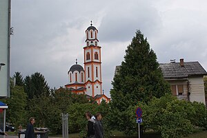
Laktaši
City in Republika Srpska, Bosnia and Herzegovina
Distance: Approx. 137 meters
Latitude and longitude: 44.90916667,17.30166667
Laktaši (Serbian Cyrillic: Лакташи) is a city in Republika Srpska, Bosnia and Herzegovina. As of 2013, the municipality had a population of 34,966 inhabitants, while the town has a population of 5,879 inhabitants.
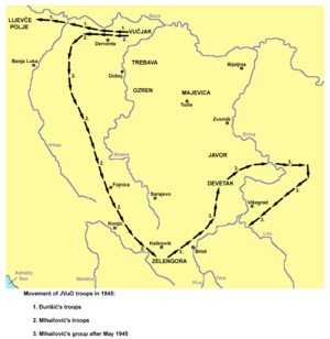
Battle of Lijevče Field
World War II battle in Yugoslavia
Distance: Approx. 6905 meters
Latitude and longitude: 44.96083333,17.34694444
The Battle of Lijevče Field (Serbo-Croatian: Bitka na Lijevča polju, Битка на Лијевча пољу) was fought between 30 March and 8 April 1945 between the Croatian Armed Forces (HOS, the amalgamated Ustashe Militia and Croatian Home Guard forces) and Chetnik forces on the Lijevče field near Banja Luka in what was then the Independent State of Croatia (NDH).

Lijevče
Small geographical region in northern Bosnia and Herzegovina
Distance: Approx. 6905 meters
Latitude and longitude: 44.96083333,17.34694444
Lijevče, also the Lijevče field (Serbo-Croatian: Lijevče polje, Serbian Cyrillic: Лијевче поље), is a small geographical region in northern Bosnia and Herzegovina; a plain situated between the rivers Sava and Vrbas, and Mount Kozara. It includes settlements part of Gradiška, Srbac and Laktaši, in the Banja Luka region of the Republika Srpska entity. It is part of the wider Bosanska Krajina ("Bosnian Frontier") historical region.

Gradski stadion (Laktaši)
Distance: Approx. 694 meters
Latitude and longitude: 44.90694444,17.30944444
Gradski Stadion is a football stadium in Laktaši, Bosnia and Herzegovina. It is the home stadium of FK Laktaši of the Premier League of Bosnia and Herzegovina. The stadium holds 5,000 spectators.
Romanovci
Village in Republika Srpska, Bosnia and Herzegovina
Distance: Approx. 7823 meters
Latitude and longitude: 44.97444444,17.26805556
Romanovci (Serbian Cyrillic: Романовци) is a village in the municipality of Gradiška, Republika Srpska, Bosnia and Herzegovina.
Barlovci
Village in Republika Srpska, Bosnia and Herzegovina
Distance: Approx. 9214 meters
Latitude and longitude: 44.86694444,17.19944444
Barlovci (Serbian Cyrillic: Барловци) is a village in the municipality of Banja Luka, Republika Srpska, Bosnia and Herzegovina.
Slatina (Novo Goražde)
Village in Republika Srpska, Bosnia and Herzegovina
Distance: Approx. 8714 meters
Latitude and longitude: 44.83,17.2933
Slatina (Cyrillic: Слатина) is a village in the municipality of Novo Goražde, Republika Srpska, Bosnia and Herzegovina.
Banja Luka Zalužani Airfield
Distance: Approx. 9143 meters
Latitude and longitude: 44.8486,17.2209
Banja Luka Zalužani Airfield (Serbian: Аеродром Бања Лука — Залужани, romanized: Aerodrom Banja Luka - Zalužani) is a recreational airfield on the northern outskirts of the city of Banja Luka, the second largest city in Bosnia and Herzegovina.

Papažani
Village in Republika Srpska, Bosnia and Herzegovina
Distance: Approx. 7539 meters
Latitude and longitude: 44.9236,17.3939
Papažani (Serbian Cyrillic: Папажани) is a village in the municipality of Laktaši, Republika Srpska, Bosnia and Herzegovina.

Laktaši Sports Hall
Distance: Approx. 580 meters
Latitude and longitude: 44.90722222,17.30805556
Laktaši Sports Hall (Bosnian: Спортска дворана Лакташи, romanized: Sportska dvorana Laktaši) is an indoor sporting arena located in Laktaši, Bosnia and Herzegovina. The seating capacity of the arena is 3,050 spectators for sporting events. It is home to the KK Igokea basketball team.

Church of St. Nicholas, Romanovci
Church
Distance: Approx. 7184 meters
Latitude and longitude: 44.96777778,17.26611111
Church of St. Nicholas (Serbian: Црква брвнара у Романовцима) is a temple of the Serbian Orthodox Church located in Romanovci in the municipality of Gradiška, Republika Srpska. It belongs to the Eparchy of Banja Luka.
Weather in this IP's area
light rain
3 Celsius
1 Celsius
3 Celsius
3 Celsius
1023 hPa
100 %
1023 hPa
999 hPa
5000 meters
2.06 m/s
330 degree
40 %