Country:
 Spain
SpainRegion:
City:
Latitude and Longitude:
Time Zone:
Postal Code:
IP information under different IP Channel
ip-api
Country
Region
City
ASN
Time Zone
ISP
Blacklist
Proxy
Latitude
Longitude
Postal
Route
IPinfo
Country
Region
City
ASN
Time Zone
ISP
Blacklist
Proxy
Latitude
Longitude
Postal
Route
MaxMind
Country
Region
City
ASN
Time Zone
ISP
Blacklist
Proxy
Latitude
Longitude
Postal
Route
Luminati
Country
ESRegion
an
City
ubrique
ASN
Time Zone
Europe/Madrid
ISP
Vodafone Spain
Latitude
Longitude
Postal
db-ip
Country
Region
City
ASN
Time Zone
ISP
Blacklist
Proxy
Latitude
Longitude
Postal
Route
ipdata
Country
Region
City
ASN
Time Zone
ISP
Blacklist
Proxy
Latitude
Longitude
Postal
Route
Popular places and events near this IP address
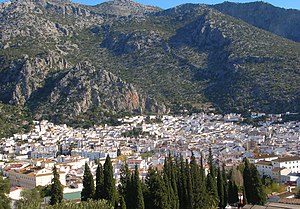
Ubrique
Municipality in Spain
Distance: Approx. 367 meters
Latitude and longitude: 36.68333333,-5.45
Ubrique is a municipality of Spain located in the province of Cádiz, in the autonomous community of Andalusia. According to the 2005 census, it has a population of 17,362 inhabitants. It is the most important municipality in the Sierra de Cádiz.

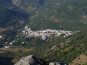
Benaocaz
Municipality in Andalusia, Spain
Distance: Approx. 3325 meters
Latitude and longitude: 36.7,-5.41666667
Benaocaz is a village located in the province of Cádiz, Spain. According to the 2006 census, the city has a population of 729 inhabitants. The town's name dates back to the Moors, and derives from The Arabic Ocaz family, with ‘Ben’ meaning “son of”.

El Bosque, Spain
Municipality in Andalusia, Spain
Distance: Approx. 8968 meters
Latitude and longitude: 36.75,-5.5
El Bosque is a town and municipality located in the province of Cádiz, Spain. According to the 2005 census, the city has a population of 2,004 inhabitants.

Villaluenga del Rosario
Place in Cádiz
Distance: Approx. 5971 meters
Latitude and longitude: 36.7,-5.38333333
Villaluenga del Rosario is a village located in the province of Cádiz, Spain. According to the 2005 census, the city has a population of 481 inhabitants. It is located down Navazo Alto mountain, within the Sierra de Grazalema Natural Park.

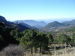
Sierra de Grazalema Natural Park
Distance: Approx. 9792 meters
Latitude and longitude: 36.769,-5.431
The Sierra de Grazalema Natural Park (Spanish: Parque natural de la Sierra de Grazalema) is a natural park in the northeastern part of the province of Cádiz in southern Spain. The park encompasses, within its 51,695 hectares (127,740 acres), a complex of mountain ranges, known collectively as the Sierra de Grazalema, which, in turn, are part of the Cordillera Subbética. Other ranges within the park, comprising the Sierra de Grazalema, include the Sierra de Zafalgar, the Sierra del Pinar, and the Sierra de Endrinal.
Benamahoma
Distance: Approx. 9610 meters
Latitude and longitude: 36.76666667,-5.46666667
Benamahoma (Arabic “Sons of Muhammad”), one of the White Towns of Andalusia, is a town of some 400 inhabitants in Cádiz province, Spain. It is located 5 km from El Bosque, Cádiz, and lies within the Sierra de Grazalema Natural Park.
Puerto del Boyar
Distance: Approx. 9418 meters
Latitude and longitude: 36.75583333,-5.395
The Puerto de las Palomas is a road through two mountains inside the Sierra de Grazalema Natural Park, separating Sierra del Pinar and Sierra del Endrinal. It is located inside Grazalema municipality (Province of Cádiz) at 1103 meters high.

Los Hurones Reservoir
Reservoir in Algar and Jerez de la Frontera
Distance: Approx. 7916 meters
Latitude and longitude: 36.68722222,-5.53472222
Los Hurones Reservoir is a reservoir in the province of Cádiz, Andalusia, Spain.

Castle of Aznalmara
Historic site in Ubrique, Spain
Distance: Approx. 5584 meters
Latitude and longitude: 36.729438,-5.46627
The Castle of Aznalmara (Spanish: Castillo de Aznalmara) is a castle located in Ubrique, Spain. It was declared Bien de Interés Cultural in 1993.
Weather in this IP's area
overcast clouds
16 Celsius
16 Celsius
16 Celsius
16 Celsius
1013 hPa
75 %
1013 hPa
963 hPa
10000 meters
0.77 m/s
1.95 m/s
221 degree
100 %
07:58:51
20:40:15