Country:
 Spain
SpainRegion:
City:
Latitude and Longitude:
Time Zone:
Postal Code:
IP information under different IP Channel
ip-api
Country
Region
City
ASN
Time Zone
ISP
Blacklist
Proxy
Latitude
Longitude
Postal
Route
IPinfo
Country
Region
City
ASN
Time Zone
ISP
Blacklist
Proxy
Latitude
Longitude
Postal
Route
MaxMind
Country
Region
City
ASN
Time Zone
ISP
Blacklist
Proxy
Latitude
Longitude
Postal
Route
Luminati
Country
ESRegion
an
City
seville
ASN
Time Zone
Europe/Madrid
ISP
Vodafone Spain
Latitude
Longitude
Postal
db-ip
Country
Region
City
ASN
Time Zone
ISP
Blacklist
Proxy
Latitude
Longitude
Postal
Route
ipdata
Country
Region
City
ASN
Time Zone
ISP
Blacklist
Proxy
Latitude
Longitude
Postal
Route
Popular places and events near this IP address

Ramón Sánchez Pizjuán Stadium
Association football stadium in Seville, Spain
Distance: Approx. 11 meters
Latitude and longitude: 37.384,-5.9705
The Ramón Sánchez Pizjuán Stadium (Spanish: Estadio Ramón Sánchez-Pizjuán; [esˈtaðjo raˈmon ˈsantʃeθ piθˈxwan]) is a football stadium in Seville, Spain. It is the home stadium of Sevilla, and is named after the club's former president, Ramón Sánchez-Pizjuán (1900–1956). It was the venue for the 1986 European Cup Final between Steaua București and Barcelona and the 1982 World Cup semi-final game between West Germany and France.

Estadio de Nervión
Distance: Approx. 139 meters
Latitude and longitude: 37.383608,-5.971942
Estadio de Nervión was a multi-use stadium in Seville, Spain. It was used mostly for football matches and hosted the home matches of Sevilla FC. The stadium was able to hold 20,000 people and opened in 1928. It was closed in 1958 when Estadio Ramón Sánchez Pizjuán opened.
Nervión, Seville
Distance: Approx. 250 meters
Latitude and longitude: 37.3856,-5.9726
Nervión is a district of Seville, Spain. It lies to the east of the city centre (the Casco Antiguo), to the north of the Distrito Sur, to the south of San Pablo-Santa Justa and to the west of Cerro-Amate. The district is an important commercial district of the city, where much of the regional capital's business takes place.
Bellavista, Seville
Distance: Approx. 1138 meters
Latitude and longitude: 37.38333333,-5.98333333
Bellavista is a neighbourhood in the Bellavista-La Palmera district in the south of the city of Seville, Andalusia, Spain. It lies on the east bank of the Guadaira river, a tributary of the Guadalquivir. Bellavista once belonged to the town of Dos Hermanas, but were sold to the city of Seville.

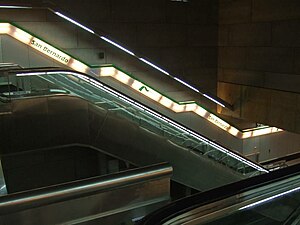
Nervión (Seville Metro)
Seville Metro station
Distance: Approx. 345 meters
Latitude and longitude: 37.38305556,-5.97416667
Nervión (English: Nervion) is an underground station of the Seville Metro on the line 1. The station is located at the intersection of the avenues of Eduardo Dato and San Fco. Javier, in the neighborhood of Nervión.

Gran Plaza (Seville Metro)
Seville Metro station
Distance: Approx. 434 meters
Latitude and longitude: 37.38166667,-5.96666667
Gran Plaza (English: Great Square) is an underground station of the Seville Metro on the line 1. It is located at the intersection of Eduardo Dato and Cruzcampo avenues, in the neighborhood of Nervión. Gran Plaza station is located by the Gran Plaza square, between the stations Nervión and 1º de Mayo on the same line.
San Bernardo railway station
Railway station in Seville, Spain
Distance: Approx. 1000 meters
Latitude and longitude: 37.37861111,-5.97944444
San Bernardo (English: Saint Bernard) is a railway interchange station of metro and suburban trains services of Seville, Andalusia. It is located at the intersection of the avenues of La Enramadilla and La Buhaira in the neighborhood of San Bernardo. San Bernardo is an underground station of line 1 of the metro and the lines C-1 and C-4 of the suburban trains (Spanish: Cercanías).
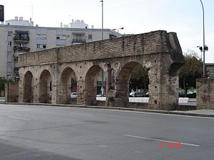
Caños de Carmona
Distance: Approx. 1168 meters
Latitude and longitude: 37.3883,-5.9826
The Caños de Carmona (Pipes of Carmona, Spanish pronunciation: ['kaɲos de kaɾ'mona]) is a Roman aqueduct built during the first century BC to supply water from a spring in the ancient Roman city of Irippo –current Alcalá de Guadaíra– to the ancient Roman city of Hispalis –current Seville–, both in the ancient Roman province of Hispania Ulterior –current Spain–. It was later renovated and partially re-built in the twelfth century by the Almohads and it was fully operational until its demolition in 1912. Some sections survived the demolition and remain standing today.

Immaculate Heart of Mary College, Portaceli
Jesuit, catholic school in Seville, Spain
Distance: Approx. 654 meters
Latitude and longitude: 37.38305556,-5.97777778
Immaculate Heart of Mary College, Portaceli, Seville, covers pre-primary through baccalaureate and technical school. It was founded by the Jesuits in 1950. The College offers the Baccalaureate in both Science and Technology and Humanities and Social Sciences.

Antiguo Matadero de Sevilla
Distance: Approx. 1161 meters
Latitude and longitude: 37.37517,-5.96372
The Antiguo Matadero de Sevilla (transl. Former Slaughterhouse of Seville) is a building located in Seville (Andalusia, Spain). It was built in 1916. It is Neo-Mudéjar style and its bricks with azulejos and flat roof tiles, make it a typical building of Sevillian regional architecture.

Seville–Santa Justa railway station
Railway station in Spain
Distance: Approx. 986 meters
Latitude and longitude: 37.3922,-5.975
Seville–Santa Justa railway station is the major railway station of the Spanish city of Seville, Andalusia. It was opened in 1991 with the inauguration of the Madrid–Seville high-speed rail line, and serves around 9.25 million passengers a year.

Buhaira Gardens
Historic monument in Seville, Spain
Distance: Approx. 785 meters
Latitude and longitude: 37.38266667,-5.97919444
The Buhaira Gardens, also known as the Buhaira Palace or the Buḥayra (transliteration of Arabic: بحيرة), is a former Almohad garden and palace in Seville, Spain. It was created in the 12th century. After the Reconquista it was also known in Spanish as the Huerta del Rey ("Garden of the King") or Huerta Dabenahofar in its later history.: 211 It is now a public park and historic site.
Weather in this IP's area
clear sky
19 Celsius
19 Celsius
18 Celsius
19 Celsius
1012 hPa
61 %
1012 hPa
1010 hPa
10000 meters
2.06 m/s
200 degree
08:00:28
20:42:48