Country:
 Spain
SpainRegion:
City:
Latitude and Longitude:
Time Zone:
Postal Code:
IP information under different IP Channel
ip-api
Country
Region
City
ASN
Time Zone
ISP
Blacklist
Proxy
Latitude
Longitude
Postal
Route
IPinfo
Country
Region
City
ASN
Time Zone
ISP
Blacklist
Proxy
Latitude
Longitude
Postal
Route
MaxMind
Country
Region
City
ASN
Time Zone
ISP
Blacklist
Proxy
Latitude
Longitude
Postal
Route
Luminati
Country
ESRegion
an
City
algeciras
ASN
Time Zone
Europe/Madrid
ISP
Vodafone Spain
Latitude
Longitude
Postal
db-ip
Country
Region
City
ASN
Time Zone
ISP
Blacklist
Proxy
Latitude
Longitude
Postal
Route
ipdata
Country
Region
City
ASN
Time Zone
ISP
Blacklist
Proxy
Latitude
Longitude
Postal
Route
Popular places and events near this IP address
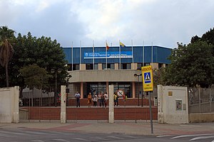
Pabellón Ciudad de Algeciras
Distance: Approx. 1881 meters
Latitude and longitude: 36.1426,-5.4513
Pabellón Ciudad de Algeciras-Doctor Juan Carlos Mateo is an arena in Algeciras, Spain. It is primarily used for team handball and is the home arena of Algeciras BM. The arena holds 2,300 people. Initially named as only Ciudad de Algeciras, on 10 May 2017, the pavilion changed its denomination by adding the name of Doctor Juan Carlos Mateo.
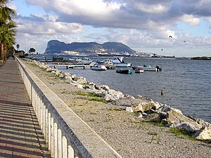
Port of Algeciras
Port in Spain
Distance: Approx. 2160 meters
Latitude and longitude: 36.136,-5.435
The Port of Algeciras is the port and harbour of Algeciras, a city located in the province of Cádiz in the autonomous community of Andalusia, Spain. It is a commercial, fishing and passenger port. Primarily a transshipment port, its position near the Strait of Gibraltar and key east–west shipping routes establishes it as one of the busiest transshipment hubs in the world.

Italian auxiliary ship Olterra
Undercover Italian auxiliary ship from World War II
Distance: Approx. 1436 meters
Latitude and longitude: 36.1425,-5.43555556
The auxiliary ship Olterra was a 5,000 ton Italian tanker scuttled by her own crew at Algeciras in the Bay of Gibraltar on 10 June 1940, after the entry of Italy in World War II. She was recovered in 1942 by a special unit of the Decima Flottiglia MAS to be used as an undercover base for manned torpedoes in order to attack Allied shipping at Gibraltar.

Torre del Almirante
Historic site in Algeciras, Spain
Distance: Approx. 1002 meters
Latitude and longitude: 36.148925,-5.445374
Torre del Almirante (English: Tower of the admiral) is a tower located in Algeciras, Spain. It was declared Bien de Interés Cultural in 1985. The date of this tower is unknown and it pre-dates many other towers that were built around the Bay of Gibraltar and south of Algeciras as batteries and watchtowers.
Battle of Carteia (naval)
Distance: Approx. 2089 meters
Latitude and longitude: 36.1603,-5.4151
The Battle of Carteia was a naval battle of the Second Punic War, fought between the navy of the Roman Republic and a Carthaginian fleet in 206 BC near the ancient city of Carteia in southern Spain. The Roman navy was commanded by Gaius Laelius and the Carthaginian navy by Adherbal. The battle resulted in a Roman victory.
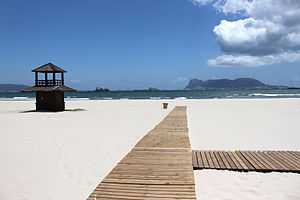
Playa de El Rinconcillo
Distance: Approx. 426 meters
Latitude and longitude: 36.15777778,-5.44111111
Playa de El Rinconcillo is a beach in the Province of Cadiz, Andalusia, Spain, located to the north of the city of Algeciras, near the neighborhood of El Rinconcillo. It looks across to the rock of Gibraltar and La Línea de la Concepción. It extends from the Puente de Acceso Norte access to the mouth of the Rio Palmones, a total length of 2550 metres and an average width of 40 metres including Rinconcillo beach itself and a small cove called La Concha.
Palmones (river)
Distance: Approx. 1320 meters
Latitude and longitude: 36.16666667,-5.43333333
The Río Palmones is a river of the Province of Cádiz in Southeastern coastal Spain. Its source is in Lomas del Castaño, Sierra Blanquilla, and it flows for some 37 kilometres (23 mi) into the Bay of Gibraltar, North of the city of Algeciras, in the neighborhood of Palmones. The Battle of Río Palmones took place here in 1342.
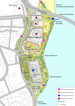
Paseo Cornisa
Park in Spain
Distance: Approx. 1372 meters
Latitude and longitude: 36.14527778,-5.44638889
Paseo Cornisa is a park in Algeciras, Spain. It was inaugurated in May 2007. It stretches for just over a kilometre between Punta del Cementerio and Punta del Almirante in the north of the city near the old cemetery and parallel to the Playa del Barranco and Playa de El Rinconcillo.

Playa del Barranco
Beach in Spain
Distance: Approx. 1356 meters
Latitude and longitude: 36.145,-5.44555556
Playa del Barranco is a beach in the municipality of Algeciras, southeastern Spain. It overlooks the Bay of Algeciras. It is approximately 500 metres in length.

Playa de Los Ladrillos
Beach in Spain
Distance: Approx. 1864 meters
Latitude and longitude: 36.14027778,-5.44666667
Playa de Los Ladrillos is a beach in the municipality of Algeciras, southeastern Spain. It overlooks the Bay of Algeciras, next to Playa del Barranco. It is about 200 metres in length.

Algeciras Municipal Library
Distance: Approx. 2168 meters
Latitude and longitude: 36.14888889,-5.46027778
Algeciras Municipal Library (Spanish: biblioteca municipal de Algeciras) is a public library network in Algeciras, Spain. Its headquarters are at the Biblioteca Cristóbal Delgado (Library Christopher Delgado), located on Salvador Allende Street. There are two branches, including one in the Saladillo neighborhood, Biblioteca El Saladillo, and another in the La Granja neighborhood, Biblioteca Pérez Petinto.
Roman kilns of El Rinconcillo
Distance: Approx. 996 meters
Latitude and longitude: 36.1579,-5.4481
The Roman kilns of El Rinconcillo (Spanish: Hornos romanos de El Rinconcillo) were Roman kilns located in the Spanish city of Algeciras. They were part of manufacturing complex of Portus Albus, which supplied container for transport to the processing industry of the neighboring city of Iulia Traducta, besides making other ceramic household products and items. The kilns were discovered in 1966 by archaeologist Manuel Sotomayor, just 300 meters from the Playa de El Rinconcillo.
Weather in this IP's area
few clouds
22 Celsius
22 Celsius
22 Celsius
22 Celsius
1013 hPa
85 %
1013 hPa
1013 hPa
10000 meters
8.23 m/s
300 degree
20 %
07:59:09
20:39:52