Country:
 Spain
SpainRegion:
City:
Latitude and Longitude:
Time Zone:
Postal Code:
IP information under different IP Channel
ip-api
Country
Region
City
ASN
Time Zone
ISP
Blacklist
Proxy
Latitude
Longitude
Postal
Route
IPinfo
Country
Region
City
ASN
Time Zone
ISP
Blacklist
Proxy
Latitude
Longitude
Postal
Route
MaxMind
Country
Region
City
ASN
Time Zone
ISP
Blacklist
Proxy
Latitude
Longitude
Postal
Route
Luminati
Country
ESRegion
an
City
losbarrios
ASN
Time Zone
Europe/Madrid
ISP
Vodafone Spain
Latitude
Longitude
Postal
db-ip
Country
Region
City
ASN
Time Zone
ISP
Blacklist
Proxy
Latitude
Longitude
Postal
Route
ipdata
Country
Region
City
ASN
Time Zone
ISP
Blacklist
Proxy
Latitude
Longitude
Postal
Route
Popular places and events near this IP address

Punta Carnero, Spain
Distance: Approx. 2669 meters
Latitude and longitude: 36.0771,-5.4253
Punta Carnero is a headland on the coast of Spain, near the city of Algeciras, where the eastern end of Gallows Hill descends 200 metres to meet the Mediterranean Sea. Its most prominent feature is Punta Carnero lighthouse, which marks the entrance to the Bay of Gibraltar and the Strait of Gibraltar. Goat Island lies near the lighthouse, and the Bay of Getares begins here.

Fuerte de Isla Verde
Distance: Approx. 2658 meters
Latitude and longitude: 36.123247,-5.434642
Fuerte de Isla Verde (English: Green Island Fort) was a military installation formerly located in Algeciras, Spain. It occupied the Isla Verde (English: Green Island), which gave its name to the city as a whole (via the Arabic name Al-Jazira Al-Khadra', English: Green Island, corrupted into "Algeciras"). The elongated island, which stood a short distance offshore of the city's old town, was already the site of an artillery battery in 1720.

Isla Verde Lighthouse
Lighthouse
Distance: Approx. 2604 meters
Latitude and longitude: 36.12272222,-5.43394444
Lighthouse of Isla Verde (Spanish: Faro de Isla Verde) is an inactive lighthouse in Algeciras, Spain. It is located at the southern end of an old fort, on Isla Verde, an island that has been incorporated into the Port of Algeciras. The lighthouse was designed and built by Jaime Font in 1863 and inaugurated in 1864.
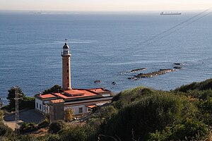
Punta Carnero Lighthouse
Lighthouse
Distance: Approx. 2635 meters
Latitude and longitude: 36.07714444,-5.42623889
Punta Carnero Lighthouse (Spanish: Faro de Punta Carnero) is an active lighthouse located on the headland known as Punta Carnero to the south of Algeciras, Spain. The lighthouse was designed and built by Jaime Font, who also designed the lighthouse at Chipiona. Opened in 1874, it overlooks the Strait of Gibraltar.

Torre del Arroyo del Lobo
Historic site in Algeciras, Spain
Distance: Approx. 1871 meters
Latitude and longitude: 36.09055556,-5.45388889
Torre del Arroyo del Lobo is a ruined medieval defensive tower near Algeciras, Spain. It is located in the cove of Getares, and monitored the stretch of coast from Punta Carnero to Punta de San García between the cities of Algeciras and Tarifa as part of the defensive system of the Strait of Gibraltar in the Middle Ages. The tower is situated as 76.3 meters above sea level and 935 meters from the coast.

Pícaro
River in Spain
Distance: Approx. 1243 meters
Latitude and longitude: 36.1,-5.45
Río Pícaro is a river of southeastern Andalusia, Spain. Originating in the Sierra del Bujeo /Sierra del Algarrobo, it flows for 7.7 kilometres (4.8 mi) into the Bay of Algeciras, not far from Algeciras. The terrain of the river course is rugged; Pícaro is Spanish for rogue.

Hotel Reina Cristina
Distance: Approx. 2765 meters
Latitude and longitude: 36.12333333,-5.44444444
Hotel Reina Cristina is an historic hotel in Algeciras, Spain. It was opened in 1901. It is representative of the British colonial architecture imported into the city in the early twentieth century from the nearby British Overseas Territory of Gibraltar.
Playa de El Chinarral
Distance: Approx. 1428 meters
Latitude and longitude: 36.11222222,-5.43666667
Playa de El Chinarral is a beach in the municipality of Algeciras, southeastern Spain. It overlooks the Bay of Algeciras and the tip of the rock of Gibraltar. It is approximately 250 metres in length and 40 metres wide on average.

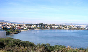
Playa de Getares
Distance: Approx. 749 meters
Latitude and longitude: 36.095,-5.4425
Playa de Getares is a beach in the municipality of Algeciras, southeastern Spain. It overlooks the Bay of Gibraltar about 5 kilometres (3.1 mi) south of the city of Algeciras, between Punta San García and Punta Carnero, where the cliffs begin on the Strait of Gibraltar. It is approximately 1.5 kilometres (0.93 mi) in length and 40 metres (130 ft) wide on average.
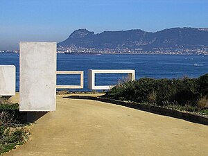
Parque del Centenario
Distance: Approx. 908 meters
Latitude and longitude: 36.10722222,-5.43333333
The Parque del Centenario (Centennial Park) is a park located in Algeciras. It was established in 2007 thanks to the collaboration between the Port Authority of the Bay of Algeciras and City Hall to mark the hundredth anniversary of the Algeciras Conference. The park covers more than 100,000 m2, and lies on the ruins of the old Fuerte de San García, destroyed around 1811 by the British troops on the occasion of the independence war between Spain and France.

Fuerte de San García
Historic site in Algeciras, Spain
Distance: Approx. 851 meters
Latitude and longitude: 36.10611111,-5.43166667
Fuerte de San García was a fort in Algeciras, Spain, It was built in the 1730s and destroyed in 1811 to deny it to the French. Today all that remains are the foundation and base ruins, in the Parque del Centenario, but it is a registered Bien de Interés Cultural landmark The Spanish fortifications around Gibraltar were destroyed in 1810 to deny their use by Napoleon's forces. the fortifications around the bay were removed by Portuguese sailors and this was only shortly before the French cavalry arrived in nearby San Roque.

Fuerte de Punta Carnero
Historic site in Algeciras, Spain
Distance: Approx. 2640 meters
Latitude and longitude: 36.07722,-5.4258
Fuerte de Punta Carnero was a fort near Algeciras in Spain. It was built before 1735 and was destroyed in 1810 to deny it to the French. Today all that remains are ruined foundations which are a registered Bien de Interés Cultural landmark.
Weather in this IP's area
clear sky
17 Celsius
16 Celsius
17 Celsius
17 Celsius
1025 hPa
76 %
1025 hPa
1025 hPa
10000 meters
4.63 m/s
270 degree
08:31:20
19:42:00