Country:
 Spain
SpainRegion:
City:
Latitude and Longitude:
Time Zone:
Postal Code:
IP information under different IP Channel
ip-api
Country
Region
City
ASN
Time Zone
ISP
Blacklist
Proxy
Latitude
Longitude
Postal
Route
IPinfo
Country
Region
City
ASN
Time Zone
ISP
Blacklist
Proxy
Latitude
Longitude
Postal
Route
MaxMind
Country
Region
City
ASN
Time Zone
ISP
Blacklist
Proxy
Latitude
Longitude
Postal
Route
Luminati
Country
ESRegion
nc
City
berriozar
ASN
Time Zone
Europe/Madrid
ISP
Vodafone Spain
Latitude
Longitude
Postal
db-ip
Country
Region
City
ASN
Time Zone
ISP
Blacklist
Proxy
Latitude
Longitude
Postal
Route
ipdata
Country
Region
City
ASN
Time Zone
ISP
Blacklist
Proxy
Latitude
Longitude
Postal
Route
Popular places and events near this IP address

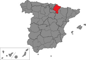
Navarre
Autonomous community and province of Spain
Distance: Approx. 2326 meters
Latitude and longitude: 42.81666667,-1.65
Navarre ( nə-VAR; Spanish: Navarra [naˈβara] ; Basque: Nafarroa [nafaro.a]), officially the Chartered Community of Navarre, is a landlocked foral autonomous community and province in northern Spain, bordering the Basque Autonomous Community, La Rioja, and Aragon in Spain and Nouvelle-Aquitaine in France. The capital city is Pamplona (Basque: Iruña). The present-day province makes up the majority of the territory of the medieval Kingdom of Navarre, a long-standing Pyrenean kingdom that occupied lands on both sides of the western Pyrenees, with its northernmost part, Lower Navarre, located in the southwest corner of France.

Pamplona
Municipality in Navarre, Spain
Distance: Approx. 2326 meters
Latitude and longitude: 42.81666667,-1.65
Pamplona (Spanish: [pamˈplona] ; Basque: Iruña [iɾuɲa]), historically also known as Pampeluna in English, is the capital city of the Chartered Community of Navarre, in Spain. Lying at near 450 m (1,480 ft) above sea level, the city (and the wider Cuenca de Pamplona) is located on the flood plain of the Arga river, a second-order tributary of the Ebro. Precipitation-wise, it is located in a transitional location between the rainy Atlantic northern façade of the Iberian Peninsula and its drier inland.
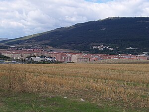
Berriozar
Distance: Approx. 827 meters
Latitude and longitude: 42.83611111,-1.67138889
Berriozar is a town located in the province of Navarre, in the autonomous community of Navarre, in the North of Spain. It is 6 km from Pamplona, forming part of Pamplona's metropolitan area. Berriozar's population in 2013 was 9.605 people.

Orkoien
Municipality in Navarre, Spain
Distance: Approx. 2189 meters
Latitude and longitude: 42.82388889,-1.69916667
Orcoyen (Basque: Orkoien) is a town and municipality located in the province and autonomous community of Navarre, northern Spain, being part of Pamplona's metropolitan area. Its population currently stands at 3,637 inhabitants. Its population density is of 0.69 inhabitants/km2.
Navarre (Congress of Deputies constituency)
Distance: Approx. 2326 meters
Latitude and longitude: 42.81666667,-1.65
Navarre (Spanish: Navarra, Basque: Nafarroa) is one of the 52 constituencies (Spanish: circunscripciones) represented in the Congress of Deputies, the lower chamber of the Spanish parliament, the Cortes Generales. The constituency currently elects five deputies. Its boundaries correspond to those of the Spanish province of Navarre.
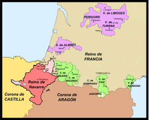
Spanish conquest of Iberian Navarre
Conflicts over control of Navarre (1512–1529)
Distance: Approx. 2641 meters
Latitude and longitude: 42.8183,-1.6442
The Spanish conquest of the Iberian part of Navarre was initiated by Ferdinand II of Aragon and completed by his grandson and successor Charles V in a series of military campaigns lasting from 1512 to 1524. Ferdinand was both the king of Aragon and regent of Castile in 1512. When Pope Julius II declared a Holy League against France in late 1511, Navarre attempted to remain neutral.
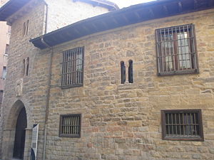
Cámara de Comptos de Navarra
Historic site in Pamplona, Spain
Distance: Approx. 2573 meters
Latitude and longitude: 42.817471,-1.645731
The Cámara de los Comptos (Spanish: Cámara de los Comptos) is a building located in Pamplona, Spain. It was declared Bien de Interés Cultural in 1868.

Museum of Navarre, Pamplona
Museum in Pamplona, Navarre, Spain
Distance: Approx. 2421 meters
Latitude and longitude: 42.8195,-1.6464
The Museum of Navarra (Spanish: Museo de Navarra; Basque: Nafarroako Museoak) is the art museum of Navarre, and is located on Calle Cuesta Santo Domingo in Pamplona, in the Navarre province of Spain.

Pamplona railway station
Distance: Approx. 1049 meters
Latitude and longitude: 42.82498,-1.66145
Pamplona/Iruña railway station (Pamplona in Spanish, Iruña in Basque and Pamplona/Iruña officially) is the central railway station of Pamplona/Iruña in Navarre, Spain. Commonly referred locally as the RENFE station or Sanduzelai station, the station is part of the Adif and high-speed rail systems.

Palacio de los Condes del Vado y de Guenduláin
Distance: Approx. 2652 meters
Latitude and longitude: 42.81661,-1.6453
The Palacio de los Condes del Vado y de Guenduláin is a palace located in the city of Toledo, in Castile-La Mancha, Spain.
Navarre (Senate constituency)
Senate constituency in Spain
Distance: Approx. 2326 meters
Latitude and longitude: 42.81666667,-1.65
Navarre is one of the 59 constituencies (Spanish: circunscripciones) represented in the Senate of Spain, the upper chamber of the Spanish parliament, the Cortes Generales. The constituency elects four senators. Its boundaries correspond to those of the Spanish province of Navarre.

City Hall Square, Pamplona-Iruña (Spain)
Square in Navarre, Spain
Distance: Approx. 2653 meters
Latitude and longitude: 42.818323,-1.644018
Udaletxe Plaza or Plaza Consistorial (City Hall Square) is a town square beside Pamplona-Iruña City Hall in the center of the Pamplona-Iruña Old Town in Pamplona-Iruña, Navarre. It is worldwide known by San Fermin. The square is host to the start of the festival, on 6 July, with the txupinazo and to the end of the festival, on 14 July, with the Gaixoa Ni or Pobre de Mí.
Weather in this IP's area
few clouds
13 Celsius
13 Celsius
13 Celsius
13 Celsius
1013 hPa
94 %
1013 hPa
960 hPa
10000 meters
20 %
07:39:18
20:29:37