Country:
 Spain
SpainRegion:
City:
Latitude and Longitude:
Time Zone:
Postal Code:
IP information under different IP Channel
ip-api
Country
Region
City
ASN
Time Zone
ISP
Blacklist
Proxy
Latitude
Longitude
Postal
Route
IPinfo
Country
Region
City
ASN
Time Zone
ISP
Blacklist
Proxy
Latitude
Longitude
Postal
Route
MaxMind
Country
Region
City
ASN
Time Zone
ISP
Blacklist
Proxy
Latitude
Longitude
Postal
Route
Luminati
Country
ESRegion
cn
City
laspalmasdegrancanaria
ASN
Time Zone
Atlantic/Canary
ISP
Vodafone Spain
Latitude
Longitude
Postal
db-ip
Country
Region
City
ASN
Time Zone
ISP
Blacklist
Proxy
Latitude
Longitude
Postal
Route
ipdata
Country
Region
City
ASN
Time Zone
ISP
Blacklist
Proxy
Latitude
Longitude
Postal
Route
Popular places and events near this IP address

Valsequillo de Gran Canaria
Municipality in Canary Islands, Spain
Distance: Approx. 4522 meters
Latitude and longitude: 28,-15.46666667
Valsequillo de Gran Canaria is a town and a municipality in the eastern part of the island of Gran Canaria in the Province of Las Palmas in the Canary Islands. Its population is 9,170 (2013), and the area is 39.15 km². Valsequillo is situated in the mountains, 5 km west of Telde and 16 km southwest of Las Palmas.
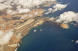
Gran Canaria Airport
Spanish airport
Distance: Approx. 7426 meters
Latitude and longitude: 27.93194444,-15.38666667
Gran Canaria Airport (IATA: LPA, ICAO: GCLP) (Spanish: Aeropuerto de Gran Canaria) is a passenger and freight airport on the island of Gran Canaria. It is an important airport within the Spanish air transport network (owned and managed by a public enterprise, AENA), as it holds the sixth position in terms of passengers, and fifth in terms of operations and cargo transported. It also ranks first of the Canary Islands in all three categories, although the island of Tenerife has higher passenger numbers overall if statistics from the two airports located on the island are combined.

Bandama Caldera
Distance: Approx. 5763 meters
Latitude and longitude: 28.03333333,-15.45555556
The Bandama Natural Monument is part of the Tafira Protected Landscape on the island of Gran Canaria in the Canary Islands, Spain. It is considered a point of geological interest, because of the Caldera de Bandama. This volcanic crater, which is geologically a maar rather than a caldera, reaches 569 m (1,867 ft) above sea level at the highest point on its rim, Pico de Bandama, and is about 1,000 m (3,300 ft) wide and 200 m (700 ft) deep.

Gran Canaria (DO)
Distance: Approx. 8707 meters
Latitude and longitude: 28.03227778,-15.49705556
Gran Canaria is a Spanish Denominación de Origen Protegida (DOP) that covers the entire island of Gran Canaria (Canary Islands, Spain) comprising 21 municipalities. It obtained its official status in 2009. The cultivation of the vine in Gran Canaria dates back to the end of the s.
Oceanic Platform of the Canary Islands
Distance: Approx. 5257 meters
Latitude and longitude: 27.99222222,-15.36833333
The Oceanic Platform of the Canary Islands (PLOCAN) is a singular scientific and technological infrastructure (ICTS) aimed to accelerate the development of knowledge and technologies for the responsible and sustainable use of the ocean, in line with the United Nations Sustainable Development Goals and strategy of Blue Growth Strategy established by the European Union. It has been partially co-funded by the European Regional Development Fund (ERDF) under the ERDF Operational Programme for the Canary Islands 2007-2013 within Axis 1 "Development of the Knowledge Economy", priority theme 02, with a co-financing rate of 85%. PLOCAN is financed and managed by a consortium comprising 50% contributions from the Government of the Canary Islands and the Spanish National Government (Ministry of Science, Innovation and Universities).
Spanish Bank of Algae
National R&D service organization
Distance: Approx. 5201 meters
Latitude and longitude: 27.99111111,-15.36888889
The Spanish Bank of Algae (BEA-Banco Español de Algas) is a national R&D service attached to the Marine Biotechnology Center (CBM-Centro de Biotecnología Marina) of the University of Las Palmas de Gran Canaria (ULPGC), which objectives are the isolation, identification, characterization, conservation and provisioning of microalgae and cyanobacteria. It was previously known as the National Bank of Algae (BNA).
The British School of Gran Canaria
Distance: Approx. 6354 meters
Latitude and longitude: 28.04517,-15.44218
The British School of Gran Canaria is a British international school on Gran Canaria in Spain. It consists of two campuses: the Tafira School in Las Palmas and the South School in San Bartolomé de Tirajana. It serves levels infants through sixth form college.
The American School of Las Palmas
Distance: Approx. 6032 meters
Latitude and longitude: 28.040975,-15.445534
The American School of Las Palmas (ASLP, Spanish: Colegio Americano de Las Palmas) is an American international school in Las Palmas, Canary Islands, Spain. It serves levels nursery through grade twelve.
Lycée Français René-Verneau
French international school in Spain
Distance: Approx. 4998 meters
Latitude and longitude: 27.991618,-15.370957
The Lycée Français René-Verneau de Gran Canaria (Spanish: Liceo Francés de Gran Canaria) is a French international school in Telde, Gran Canaria, Spain. It was established in 1974 and has integrated the Mission laïque française (Mlf) in 1986. It serves levels maternelle (preschool) through terminale, the final year of lycée (senior high school) and it allows French, English and Spanish languages learning from preschool for all children.

Punta de Melenara Lighthouse
Lighthouse on Gran Canaria, Spain
Distance: Approx. 5297 meters
Latitude and longitude: 27.99177,-15.36792
The Punta de Melenara Lighthouse (Spanish: Faro de Punta de Melenara) also known as the Faro de Taliarte is an active 20th century lighthouse on the Spanish island of Gran Canaria in the Canary islands. The lighthouse has been constructed on Melenara Point, a rocky headland between the beaches of Playa del Hombre and Playa de Melenara, which lies next to the settlement of Taliarte and its port, in the municipality of Telde. Located on the eastern side of the island, the Punta de Melenara light marks the coastline between the La Isleta lighthouse of Las Palmas to the north and the Punta de Arinaga lighthouse to the south.

Four Doors cave site, Telde
Cave
Distance: Approx. 2979 meters
Latitude and longitude: 27.96440167,-15.418496
The Four Doors (in Spanish Cuatro Puertas) site, also known as Montaña Bermeja, 'Vermillion Mountain', is a complex of caves in the south of the municipality of Telde, Gran Canaria. The Cuatro Puertas site is named after its most spectacular cave, the most emblematic of Gran Canaria due to its uniqueness and location. The site includes many other caves, some linked with each other.

Gando Air Base
Spanish Air and Space Force base
Distance: Approx. 7429 meters
Latitude and longitude: 27.936,-15.379
The Gando Air Base (in Spanish: Base Aérea de Gando) is a base of the Spanish Air and Space Force located in the Gran Canaria island, Spain, and next to the Gran Canaria Airport, eastward from its runways. Beyond several hangars opposite to the passenger terminal, the Gando Air Base contains ten shelters situated on the southern end of the eastern runway. They harbor the 46 Wing (Ala 46) which operates F/A-18 Hornet and CASA/IPTN CN-235 aircraft, and the SAR Eurocopter AS 532.
Weather in this IP's area
scattered clouds
21 Celsius
21 Celsius
21 Celsius
23 Celsius
1025 hPa
64 %
1025 hPa
1006 hPa
10000 meters
8.23 m/s
10 degree
40 %
08:03:49
19:29:23