94.243.214.44 - IP Lookup: Free IP Address Lookup, Postal Code Lookup, IP Location Lookup, IP ASN, Public IP
Country:
Region:
City:
Location:
Time Zone:
Postal Code:
ISP:
ASN:
language:
User-Agent:
Proxy IP:
Blacklist:
IP information under different IP Channel
ip-api
Country
Region
City
ASN
Time Zone
ISP
Blacklist
Proxy
Latitude
Longitude
Postal
Route
db-ip
Country
Region
City
ASN
Time Zone
ISP
Blacklist
Proxy
Latitude
Longitude
Postal
Route
IPinfo
Country
Region
City
ASN
Time Zone
ISP
Blacklist
Proxy
Latitude
Longitude
Postal
Route
IP2Location
94.243.214.44Country
Region
leningradskaya oblast'
City
ivangorod
Time Zone
Europe/Moscow
ISP
Language
User-Agent
Latitude
Longitude
Postal
ipdata
Country
Region
City
ASN
Time Zone
ISP
Blacklist
Proxy
Latitude
Longitude
Postal
Route
Popular places and events near this IP address

Narva
City in Estonia
Distance: Approx. 1233 meters
Latitude and longitude: 59.37583333,28.19611111
Narva is a municipality and city in Estonia. It is located in the Ida-Viru County, at the eastern extreme point of Estonia, on the west bank of the Narva river which forms the Estonia–Russia international border. With 53,626 inhabitants (as of 2023) Narva is Estonia's third largest city after capital Tallinn and Tartu.

Swedish Ingria
Part of Swedish Empire (1583–95, 1617–1721)
Distance: Approx. 1232 meters
Latitude and longitude: 59.3758,28.1961
Swedish Ingria (Swedish: Svenska Ingermanland, ‘land of Ingrians’) was a dominion of the Swedish Empire from 1583 to 1595 and then again from 1617 to 1721 in what is now the territory of Russia. At the latter date, it was ceded to the Russian Empire in the Treaty of Nystad, at the end of the Great Northern War between the two empires.

Ivangorod
Town in Leningrad Oblast, Russia
Distance: Approx. 550 meters
Latitude and longitude: 59.36666667,28.21666667
Ivangorod (Russian: Иванго́род, IPA: [ɪvɐnˈɡorət]; Estonian: Jaanilinn; Votic: Jaanilidna) is a town in Kingiseppsky District of Leningrad Oblast, Russia, located on the east bank of the Narva river which flows along the Estonia–Russia international border, 159 kilometers (99 mi) west of Saint Petersburg, 218 kilometers (135 mi) east of Tallinn, Estonia. The town's population was recorded as 9,854 (2010 Census); 11,206 (2002 Census); 11,833 (1989 Soviet census). Ivangorod is a major border crossing point and a railway station on the Tallinn–Saint Petersburg line.

Ivangorod Fortress
Castle in Ivangorod, Leningrad Oblast, Russia
Distance: Approx. 597 meters
Latitude and longitude: 59.37451111,28.20735556
Ivangorod Fortress (Russian: Ивангородская крепость; Estonian: Jaanilinna linnus; Votic: Jaanilidna) is a castle in Ivangorod, Leningrad Oblast, Russia. It was built in the 15th century. It is located on the east bank of the Narva River, which currently forms the international border between Russia and Estonia, across from the city of Narva in Estonia.

Narva Hydroelectric Station
Hydroelectric power station in Narva, Estonia
Distance: Approx. 532 meters
Latitude and longitude: 59.36777778,28.21055556
The Narva Hydroelectric Station (Russian: Нарвская гидроэлектростанция, Estonian: Narva hüdroelektrijaam) is a hydroelectric power station in Ivangorod, Russia. It is fed by the Narva Reservoir on the Narva River and is located 2 kilometres (1.2 mi) downstream of the Narva Dam (Kulgu Dam) on the east bank of the river. It was designed by a Leningrad design bureau Lenhydroproject and constructed during 1950–1955.

Siege of Narva (1704)
1704 siege during the Great Northern War
Distance: Approx. 1223 meters
Latitude and longitude: 59.37917,28.20056
The siege of Narva (Russian: Осада Нарвы, Swedish: Belägringen av Narva), also known as the second battle of Narva, was the second Russian siege of Swedish Narva during the Great Northern War from 27 June to 9 August 1704.

Narva railway station
Railway station in Narva, Estonia
Distance: Approx. 1022 meters
Latitude and longitude: 59.36861111,28.19916667
Narva railway station (Estonian: Narva raudteejaam) is the easternmost railway station in Estonia, serving the city of Narva. The station was opened in 1870, and the first station building was destroyed in 1919 during the Estonian War of Independence. The second station building was constructed in 1922, and it was demolished during World War II. Following World War II, the current neoclassical station building was constructed.

Siege of Narva (1558)
1558 military conflict in Estonia during Livonian War
Distance: Approx. 1223 meters
Latitude and longitude: 59.379167,28.200556
The siege of Narva (Estonian: Narva piiramine; Russian: Осада Нарвы) was a Russian siege of the Livonian city of Narva (in modern-day eastern Estonia) from April through May 1558, during the Livonian War. After capturing the city in July 1558, the Russians used Narva as a trading center and port to transport commerce from Pskov and Novgorod. The Russians controlled the city until 1581, when it was captured by Swedish forces under Pontus De La Gardie.

Alexander's Cathedral
Church building in Narva, Estonia
Distance: Approx. 847 meters
Latitude and longitude: 59.3706,28.2014
Alexander's Church (Estonian: Aleksandri Suurkirik) is a church of the Estonian Evangelical Lutheran Church in Narva, Estonia. Narva Church's original cornerstone was laid in summer 1881. It was congregated after Emperor Alexander II in fall 1883, after his assassination earlier in spring.

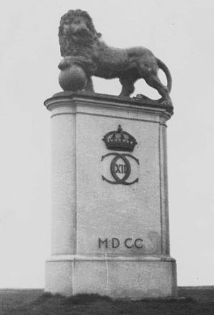
The Swedish Lion in Narva
Statue in Narva, Estonia
Distance: Approx. 887 meters
Latitude and longitude: 59.37416667,28.20138889
The Swedish Lion, or "the lion monument of Narva", are two statues erected as monuments in memory of the 1700 battle of Narva in the city of Narva in Estonia. The first version, a copy of one of the stone lions at the royal palace in Stockholm, the capital of Sweden, was erected by an entrance to the city of Narva in 1936, it was however destroyed during World War II. A new version, a copy of the "Medici lion" of the Royal Swedish Academy of Fine Arts, was erected by the Narva river in 2000.

Narva Museum
Museum in Estonia
Distance: Approx. 930 meters
Latitude and longitude: 59.3754,28.2016
Narva Museum (Estonian: Narva muuseum) is a museum in Narva, Estonia. The museum is composed of the Narva Castle, the Northern Yard, and the Narva Art Gallery. In summer 2020, new exhibition was opened in Narva Castle.

Friendship Bridge (Estonia-Russia)
Bridge in Narva, Estonia
Distance: Approx. 888 meters
Latitude and longitude: 59.3766,28.204
Friendship Bridge (Estonian: Sõpruse sild, Russian: Нарвский мост Дружбы) is a bridge spanning the Narva River. It links the city of Narva in Estonia with the town of Ivangorod in Russia. The Narva Friendship Bridge is part of the European route E20.
Weather in this IP's area
overcast clouds
2 Celsius
-2 Celsius
2 Celsius
2 Celsius
1006 hPa
100 %
1006 hPa
1002 hPa
3.97 m/s
10.47 m/s
292 degree
100 %