94.240.8.87 - IP Lookup: Free IP Address Lookup, Postal Code Lookup, IP Location Lookup, IP ASN, Public IP
Country:
 Poland
Region:
City:
Location:
Time Zone:
Postal Code:
ISP:
ASN:
language:
User-Agent:
Proxy IP:
Blacklist:
IP information under different IP Channel
ip-api
Country
Region
City
ASN
Time Zone
ISP
Blacklist
Proxy
Latitude
Longitude
Postal
Route
db-ip
Country
Region
City
ASN
Time Zone
ISP
Blacklist
Proxy
Latitude
Longitude
Postal
Route
IPinfo
Country
Region
City
ASN
Time Zone
ISP
Blacklist
Proxy
Latitude
Longitude
Postal
Route
IP2Location
94.240.8.87Country
plRegion
mazowieckie
City
lomianki
Time Zone
Europe/Warsaw
ISP
Language
User-Agent
Latitude
Longitude
Postal
ipdata
Country
Region
City
ASN
Time Zone
ISP
Blacklist
Proxy
Latitude
Longitude
Postal
Route
Popular places and events near this IP address

Battle of Wólka Węglowa
Distance: Approx. 4255 meters
Latitude and longitude: 52.295896,20.883926
The Battle of Wólka Węglowa (Polish: Bitwa pod Wólką Węglową) was a battle near Wólka Węglowa (near Warsaw) on September 19, 1939, during the last stages of the Polish counteroffensive (Battle of the Bzura) of the Invasion of Poland.

Łomianki
Town in Masovian Voivodeship, Poland
Distance: Approx. 200 meters
Latitude and longitude: 52.33333333,20.88333333
Łomianki [wɔˈmʲaŋkʲi] is a town in Warsaw West County, Masovian Voivodeship, Poland. It had a population of 16,374 in 2008, and 24,270 in 2020. It is part of the Warsaw metropolitan area.
Gmina Łomianki
Gmina in Masovian Voivodeship, Poland
Distance: Approx. 200 meters
Latitude and longitude: 52.33333333,20.88333333
Gmina Łomianki is an urban-rural gmina (administrative district) in Warsaw West County, Masovian Voivodeship, in east-central Poland. Its seat is the town of Łomianki, which lies approximately 15 kilometres (9 mi) north-east of Ożarów Mazowiecki and 16 km (10 mi) north-west of Warsaw. It covers an area of 38.06 square kilometres (14.7 sq mi), and as of 2008 its total population is 23,155.

Dziekanów Bajkowy
Village in Masovian Voivodeship, Poland
Distance: Approx. 3511 meters
Latitude and longitude: 52.3575,20.85138889
Dziekanów Bajkowy [d͡ʑɛˈkanuf bai̯ˈkɔvɨ] is a village in the administrative district of Gmina Łomianki, within Warsaw West County, Masovian Voivodeship, in east-central Poland. It lies approximately 4 kilometres (2 mi) north-west of Łomianki, 17 km (11 mi) north of Ożarów Mazowiecki, and 19 km (12 mi) north-west of Warsaw.

Dziekanów Leśny
Village in Masovian Voivodeship, Poland
Distance: Approx. 2205 meters
Latitude and longitude: 52.35,20.86666667
Dziekanów Leśny [d͡ʑɛˈkanuf ˈlɛɕnɨ] is a village in the administrative district of Gmina Łomianki, within Warsaw West County, Masovian Voivodeship, in east-central Poland. It lies approximately 3 kilometres (2 mi) north-west of Łomianki, 16 km (10 mi) north of Ożarów Mazowiecki, and 18 km (11 mi) north-west of Warsaw.

Kępa Kiełpińska
Village in Masovian Voivodeship, Poland
Distance: Approx. 3856 meters
Latitude and longitude: 52.36666667,20.86666667
Kępa Kiełpińska [ˈkɛmpa kʲɛu̯ˈpiɲska] (German Kielpiciener Kämpe) is a village in the administrative district of Gmina Łomianki, within Warsaw West County, Masovian Voivodeship, in east-central Poland. It lies approximately 4 kilometres (2 mi) north of Łomianki, 18 km (11 mi) north of Ożarów Mazowiecki, and 19 km (12 mi) north-west of Warsaw. The village was founded and settled by Vistula Germans till 1945.

Kiełpin, Masovian Voivodeship
Village in Masovian Voivodeship, Poland
Distance: Approx. 2110 meters
Latitude and longitude: 52.34805556,20.865
Kiełpin [ˈkʲɛu̯pin] is a village in the administrative district of Gmina Łomianki, within Warsaw West County, Masovian Voivodeship, in east-central Poland. It lies approximately 3 kilometres (2 mi) north-west of Łomianki, 16 km (10 mi) north of Ożarów Mazowiecki, and 18 km (11 mi) north-west of Warsaw.

Łomianki Chopina
Village in Masovian Voivodeship, Poland
Distance: Approx. 1630 meters
Latitude and longitude: 52.34861111,20.88916667
Łomianki Chopina [wɔˈmjaŋki xɔˈpina] is a village in the administrative district of Gmina Łomianki, within Warsaw West County, Masovian Voivodeship, in east-central Poland. It lies approximately 2 kilometres (1 mi) north of Łomianki, 16 km (10 mi) north-east of Ożarów Mazowiecki, and 17 km (11 mi) north-west of Warsaw.

Łomianki Dolne
Village in Masovian Voivodeship, Poland
Distance: Approx. 3748 meters
Latitude and longitude: 52.36666667,20.9
Łomianki Dolne [wɔˈmjaŋki ˈdɔlnɛ] is a village in the administrative district of Gmina Łomianki, within Warsaw West County, Masovian Voivodeship, in east-central Poland. It lies approximately 4 kilometres (2 mi) north of Łomianki, 18 km (11 mi) north of Ożarów Mazowiecki, and 18 km (11 mi) north of Warsaw.
Sadowa, Masovian Voivodeship
Village in Masovian Voivodeship, Poland
Distance: Approx. 3995 meters
Latitude and longitude: 52.35,20.83333333
Sadowa [saˈdɔva] is a village in the administrative district of Gmina Łomianki, within Warsaw West County, Masovian Voivodeship, in east-central Poland. It lies approximately 4 kilometres (2 mi) north-west of Łomianki, 15 km (9 mi) north of Ożarów Mazowiecki, and 19 km (12 mi) north-west of Warsaw.
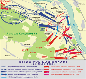
Battle of Łomianki
Distance: Approx. 657 meters
Latitude and longitude: 52.3357,20.8953
The Battle of Łomianki was a part of the opening campaign of World War II during the 1939 German invasion of Poland, fought between Polish and German forces. It was a failed counter-offensive attempt by the Polish forces.

Northern Communal Cemetery
Cemetery in Warsaw, Poland
Distance: Approx. 3565 meters
Latitude and longitude: 52.30277778,20.89694444
Northern Communal Cemetery (Polish: Cmentarz Komunalny Północny) is one of the largest cemeteries in Poland and Europe, located in Młociny and Wólka Węglowa in the Bielany district of Warsaw, Poland. The site for the cemetery was established in the 1960s at the northern outskirts of the city and partly in the area of the village of Wólka Węglowa (hence the colloquial name Cemetery in Wólka, Cmentarz na Wólce). The cemetery was opened in 1973 and so far nearly 180,000 of the dead have been buried here.
Weather in this IP's area
clear sky
-3 Celsius
-8 Celsius
-6 Celsius
-3 Celsius
1022 hPa
61 %
1022 hPa
1011 hPa
10000 meters
3.6 m/s
100 degree