94.24.60.181 - IP Lookup: Free IP Address Lookup, Postal Code Lookup, IP Location Lookup, IP ASN, Public IP
Country:
Region:
City:
Location:
Time Zone:
Postal Code:
ISP:
ASN:
language:
User-Agent:
Proxy IP:
Blacklist:
IP information under different IP Channel
ip-api
Country
Region
City
ASN
Time Zone
ISP
Blacklist
Proxy
Latitude
Longitude
Postal
Route
db-ip
Country
Region
City
ASN
Time Zone
ISP
Blacklist
Proxy
Latitude
Longitude
Postal
Route
IPinfo
Country
Region
City
ASN
Time Zone
ISP
Blacklist
Proxy
Latitude
Longitude
Postal
Route
IP2Location
94.24.60.181Country
Region
tirol
City
worgl
Time Zone
Europe/Vienna
ISP
Language
User-Agent
Latitude
Longitude
Postal
ipdata
Country
Region
City
ASN
Time Zone
ISP
Blacklist
Proxy
Latitude
Longitude
Postal
Route
Popular places and events near this IP address
Kufstein District
District in Tyrol, Austria
Distance: Approx. 3119 meters
Latitude and longitude: 47.5,12.1
The Bezirk Kufstein is an administrative district (bezirk) in Tyrol, Austria. It borders Bavaria (Germany) in the north, the Kitzbühel district in the southeast, and the Schwaz district in the southwest. The district has a geographical area of 969.81 km2, and a population of 101,321 (2012) giving a population density of 104 people per km2.
Wörgl
Municipality in Tyrol, Austria
Distance: Approx. 4 meters
Latitude and longitude: 47.48333333,12.06666667
Wörgl (German pronunciation: [ˈvœrɡəl]) is a city in the Austrian state of Tyrol, in the Kufstein district. It is 20 km (12 mi) from the international border with Bavaria, Germany.

Wildschönau
Municipality in Tyrol, Austria
Distance: Approx. 3914 meters
Latitude and longitude: 47.45,12.05
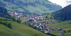
Wildschönau is a municipality within the district of Kufstein in the state of Tyrol 6 km south of Wörgl. The 24 km long high valley near Wörgl is one of the district's tourist centers. Besides a few hamlets, the municipality consists of the four church villages Niederau, Oberau, Auffach and Thierbach and is situated in the Kitzbühel Alps.

Angath
Municipality in Tyrol, Austria
Distance: Approx. 1859 meters
Latitude and longitude: 47.5,12.06666667
Angath is a municipality in the Kufstein district in the Austrian state of Tyrol located 2 km north of Wörgl and 13 km southwest of Kufstein on the northern shore of the Inn River. The village has 6 parts and acts as a dormitory suburb for commuters from Wörgl and Kufstein.

Angerberg
Municipality in Tyrol, Austria
Distance: Approx. 4198 meters
Latitude and longitude: 47.5,12.01666667
Angerberg is a municipality in the Kufstein district of Austria. It is located 2.7 kilometres (1.7 mi) north of Wörgl and 14 kilometres (9 mi) southwest of Kufstein. The village was mentioned for the first time in documents in 1190.

Bad Häring
Municipality in Tyrol, Austria
Distance: Approx. 5375 meters
Latitude and longitude: 47.5125,12.12361111
Bad Häring (Central Bavarian: Bod Hearing) is a municipality in the Kufstein district in the Austrian state of Tyrol located 4.30 km northwest of Wörgl and 9 km south of Kufstein. A strong sulfur source was found in 1951 resulting in foundation of health tourism. In 1996 the location was named the "first air spa of Tyrol“.

Kirchbichl
Municipality in Tyrol, Austria
Distance: Approx. 3714 meters
Latitude and longitude: 47.51666667,12.06666667
Kirchbichl is a municipality in the Kufstein District in the Austrian state of Tyrol located 10 km south of Kufstein and 3 km northeast above Wörgl. It has six parts and its main source of income is cement industry.

Mariastein, Tyrol
Municipality in Tyrol, Austria
Distance: Approx. 4775 meters
Latitude and longitude: 47.52527778,12.05361111
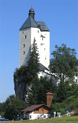
Mariastein is the smallest municipality in the Kufstein district in the Austrian state of Tyrol located 4 kilometers north of Wörgl and 11.5 kilometers southwest of Kufstein. Already a fifteenth century pilgrimage destination, it became more popular after a local statue of Mary, which had been removed to Bavaria in the late seventeenth century, was said to have returned to the church in Mariastein on its own. At the center of the community is a 42-metre-tall Wohnturm, a castle built in the fourteenth century atop a rock outcropping, and which contains 250 stairs.
Wörgl Hauptbahnhof
Railway station in Tyrol, Austria
Distance: Approx. 998 meters
Latitude and longitude: 47.49166667,12.06194444
Wörgl Hauptbahnhof is the main railway station of Wörgl, a city in the Kufstein district of the Austrian federal state of Tyrol, about 20 km from the state border with Bavaria. It is a major hub for regional and international rail travel, both passenger and freight.

Battle of Wörgl
1809 battle during the War of the Fifth Coalition
Distance: Approx. 4 meters
Latitude and longitude: 47.48333333,12.06666667
The Battle of Wörgl or Wörgel was fought on 13 May 1809, when a Bavarian force under French Marshal François Joseph Lefebvre attacked an Austrian Empire detachment commanded by Johann Gabriel Chasteler de Courcelles. The Bavarians severely defeated Chasteler's soldiers in series of actions in the Austrian towns of Wörgl, Söll, and Rattenberg. Wörgl is located 20 kilometres (12 mi) south of the modern-day German border on the upper Inn River.

Brixentaler Ache
River in Tyrol, Austria
Distance: Approx. 1914 meters
Latitude and longitude: 47.49972222,12.05916667
The Brixentaler Ache is a river of Tyrol, Austria, a right tributary of the Inn. It passes through the districts of Kitzbühel and Kufstein. It is one of the largest tributaries of the Inn in the Tyrolean Unterland by catchment area (329 km2 (127 sq mi)), but is only 26.4 km (16.4 mi) long.

Salzburg-Tyrol Railway
Railway line in Austria
Distance: Approx. 1022 meters
Latitude and longitude: 47.49166667,12.06111111
The Salzburg-Tyrol Railway (German: Salzburg-Tiroler-Bahn) is a main line railway in Austria. It runs through the states of Salzburg and Tyrol (North Tyrol) from the city of Salzburg to Wörgl and belongs to the core network (Kernnetz) of the Austrian Federal Railways (ÖBB). The section between Salzburg and Schwarzach-Sankt Veit is part of the Salzburg S-Bahn urban railway network.
Weather in this IP's area
overcast clouds
1 Celsius
1 Celsius
1 Celsius
1 Celsius
1020 hPa
85 %
1020 hPa
900 hPa
10000 meters
1.02 m/s
1.39 m/s
230 degree
100 %

