94.24.58.106 - IP Lookup: Free IP Address Lookup, Postal Code Lookup, IP Location Lookup, IP ASN, Public IP
Country:
 Austria
Region:
City:
Location:
Time Zone:
Postal Code:
ISP:
ASN:
language:
User-Agent:
Proxy IP:
Blacklist:
IP information under different IP Channel
ip-api
Country
Region
City
ASN
Time Zone
ISP
Blacklist
Proxy
Latitude
Longitude
Postal
Route
db-ip
Country
Region
City
ASN
Time Zone
ISP
Blacklist
Proxy
Latitude
Longitude
Postal
Route
IPinfo
Country
Region
City
ASN
Time Zone
ISP
Blacklist
Proxy
Latitude
Longitude
Postal
Route
IP2Location
94.24.58.106Country
atRegion
tirol
City
rettenschoss
Time Zone
Europe/Vienna
ISP
Language
User-Agent
Latitude
Longitude
Postal
ipdata
Country
Region
City
ASN
Time Zone
ISP
Blacklist
Proxy
Latitude
Longitude
Postal
Route
Popular places and events near this IP address

Walchsee
Municipality in Tyrol, Austria
Distance: Approx. 3803 meters
Latitude and longitude: 47.65111111,12.31861111
Walchsee is a municipality in the Austrian state of Tyrol in the Kufstein district. It is located in the lower Inn valley and belongs to the "Kaiserwinkl" and the "Untere Schranne".

Ebbs
Municipality in Tyrol, Austria
Distance: Approx. 5072 meters
Latitude and longitude: 47.63,12.21444444
Ebbs is a municipality in the Kufstein district of Tyrol in Austria. The village is located in the Judicial district of Kufstein and in 2016 had a population of 5,480.

Niederndorf (Austria)
Municipality in Tyrol, Austria
Distance: Approx. 4065 meters
Latitude and longitude: 47.65,12.21555556
Niederndorf is a municipality in the Kufstein district in the Austrian state of Tyrol located 7 km north of Kufstein and 2 km north above Ebbs near the border to Bavaria, Germany. The main source of income is agriculture. The village was mentioned for the first time in documents in 1230.

Niederndorferberg
Municipality in Tyrol, Austria
Distance: Approx. 2290 meters
Latitude and longitude: 47.67611111,12.25666667
Niederndorferberg is a municipality in the Kufstein district in the Austrian state of Tyrol located 8 km north of Kufstein and 3.4 km north above Ebbs near the border to Bavaria, Germany. It has six parts and was once connected with Niederndorf before it became an own community. The main source of income is the production of milk & cheese.
Rettenschöss
Municipality in Tyrol, Austria
Distance: Approx. 816 meters
Latitude and longitude: 47.65,12.26666667
Rettenschöss is a municipality in the Kufstein district in the Austrian state of Tyrol located 10.20 km northeast of Kufstein and 6 km northeast of Ebbs below the northern border to Bavaria, Germany.

Posidonia Shale
Early Jurassic geological formation of south-western Germany
Distance: Approx. 4238 meters
Latitude and longitude: 47.69,12.24
The Posidonia Shale (German: Posidonienschiefer, also called Schistes Bitumineux in Luxembourg) geologically known as the Sachrang Formation, is an Early Jurassic (Early to Late Toarcian) geological formation in Germany, northern Switzerland, northwestern Austria, southern Luxembourg and the Netherlands, including exceptionally well-preserved complete skeletons of fossil marine fish and reptiles. The Posidonienschiefer, the German translation, takes its name from the ubiquitous fossils of the oyster-related bivalve "Posidonia bronni" (synonym of Bositra buchii and Steinmannia bronni) that characterize the mollusk faunal component of the formation. The name Posidonia Shale has been used for more than a century, until revisions in 2016 proposed the Sachrang Formation as new name for the Germanic unit, in a same way Altmühltal Formation is the official name of the Solnhofen Limestone.

Vordere Kesselschneid
Distance: Approx. 5257 meters
Latitude and longitude: 47.61028,12.27667
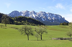
At 2,002 metres (6,568 ft) the Vordere Kesselschneid is the highest summit in the Zahmer Kaiser, the northern chain of the Kaiser Mountains in the Austrian state of Tyrol. Its summit is located southeast of the oft-visited Pyramidenspitze and is separated from it by a ca. 50 m deep saddle.
Pyramidenspitze
Distance: Approx. 5257 meters
Latitude and longitude: 47.61028,12.27667
The Pyramidenspitze is a mountain, 1,998 metres high, of the Kaisergebirge in the Austrian state of Tyrol. The Pyramidenspitze is only the second highest summit in the Zahmer Kaiser after the largely unknown, 2,002-metre-high (6,568 ft) Vordere Kesselschneid, but is the most well-known and most frequently climbed. To the south and west of the Pyramidenspitze is a high, karstified plateau, covered with mountain pine, which falls steeply into the valley of the Kaisertal and has a long arête with several summits extending towards Kufstein.

Petersköpfl
Distance: Approx. 5584 meters
Latitude and longitude: 47.609306,12.246556
The Petersköpfl is a 1,745m high summit in the Zahmer Kaiser, the northern ridge of the Kaisergebirge mountain range in the Austrian state of Tyrol. To the east, the Petersköpfl is linked by a ridge to the Einserkogel; to the west it is separated from the Naunspitze by a wind gap. To the south it falls steeply into the Kaisertal valley and to the north its steep rock faces tower above Ebbs.

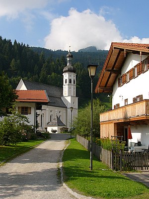
Durchholzen
Village in Tyrol, Austria
Distance: Approx. 2530 meters
Latitude and longitude: 47.63833333,12.2875
Durchholzen is a village in the municipality of Walchsee in the Austrian state of Tyrol and has 570 inhabitants.
Sachrang
Ortsteil of Aschau im Chiemgau in Bavaria, Germany
Distance: Approx. 3683 meters
Latitude and longitude: 47.69,12.26222222
The village of Sachrang is an Ortsteil (quarter) of the municipality Aschau im Chiemgau, in Bavaria, Germany. It is located 738m above sea level. It is the namesake for the Sachrang Formation.

Walchsee (lake)
Lake in Tyrol, Austria
Distance: Approx. 4330 meters
Latitude and longitude: 47.646,12.324
Walchsee is a lake in Kufstein District in both Walchsee and Kössen municipalities, Tyrol, Austria. Its surface area of 95.3 hectares (235 acres) makes it the fourth largest natural waterbody in the state. Its maximum depth is 21.2 metres (70 ft), and its maximum volume is 11,782,560 cubic metres (416,097,000 cu ft).
Weather in this IP's area
broken clouds
1 Celsius
1 Celsius
1 Celsius
2 Celsius
1026 hPa
91 %
1026 hPa
923 hPa
10000 meters
0.4 m/s
174 degree
77 %