94.232.219.57 - IP Lookup: Free IP Address Lookup, Postal Code Lookup, IP Location Lookup, IP ASN, Public IP
Country:
Region:
City:
Location:
Time Zone:
Postal Code:
ISP:
ASN:
language:
User-Agent:
Proxy IP:
Blacklist:
IP information under different IP Channel
ip-api
Country
Region
City
ASN
Time Zone
ISP
Blacklist
Proxy
Latitude
Longitude
Postal
Route
db-ip
Country
Region
City
ASN
Time Zone
ISP
Blacklist
Proxy
Latitude
Longitude
Postal
Route
IPinfo
Country
Region
City
ASN
Time Zone
ISP
Blacklist
Proxy
Latitude
Longitude
Postal
Route
IP2Location
94.232.219.57Country
Region
podkarpackie
City
korczyna
Time Zone
Europe/Warsaw
ISP
Language
User-Agent
Latitude
Longitude
Postal
ipdata
Country
Region
City
ASN
Time Zone
ISP
Blacklist
Proxy
Latitude
Longitude
Postal
Route
Popular places and events near this IP address

Krosno Voivodeship
Administrative division of Poland
Distance: Approx. 4083 meters
Latitude and longitude: 49.693161,21.76442
Krosno Voivodeship (Polish: województwo krośnieńskie) was a unit of administrative division and local government in Poland in years 1975–1998, superseded by Subcarpathian Voivodeship (except Biecz Commune which is now a part of Lesser Poland Voivodeship). Its capital city was Krosno.
Krosno
Place in Subcarpathian Voivodeship, Poland
Distance: Approx. 5578 meters
Latitude and longitude: 49.68333333,21.75
Krosno [ˈkrɔsnɔ] (in full The Royal Free City of Krosno, Polish: Królewskie Wolne Miasto Krosno) is a historical town and county in the Subcarpathian Voivodeship, in southeastern Poland. The estimated population of the town is 47,140 inhabitants as of 2014. The functional urban area of Krosno has a population of 115,000 inhabitants.

Krosno County
County in Subcarpathian Voivodeship, Poland
Distance: Approx. 5578 meters
Latitude and longitude: 49.68333333,21.75
Krosno County (Polish: powiat krośnieński) is a unit of territorial administration and local government (powiat) in Subcarpathian Voivodeship, south-eastern Poland, on the Slovak border. It came into being on January 1, 1999, as a result of the Polish local government reforms passed in 1998. Its administrative seat is the city of Krosno, although the city is not part of the county (it constitutes a separate city county).
Sucha Góra TV Tower
Place
Distance: Approx. 4547 meters
Latitude and longitude: 49.75611111,21.81611111
Sucha Góra TV Tower ( Polish: RTCN Sucha Góra) is a 149 metre tall TV tower of reinforced concrete, situated on the Sucha Góra mountain north of Czarnorzeki, Subcarpathian Voivodeship in Poland at 49°45′22″N 21°48′58″E. Sucha Góra TV tower was built in 1962.
Gmina Korczyna
Gmina in Subcarpathian Voivodeship, Poland
Distance: Approx. 539 meters
Latitude and longitude: 49.71666667,21.81666667
Gmina Korczyna is a rural gmina (administrative district) in Krosno County, Subcarpathian Voivodeship, in south-eastern Poland. Its seat is the village of Korczyna, which lies approximately 7 kilometres (4 mi) north-east of Krosno and 38 km (24 mi) south of the regional capital Rzeszów. The gmina covers an area of 92.44 square kilometres (35.69 sq mi), and as of 2006 its total population is 10,733.
Gmina Krościenko Wyżne
Gmina in Subcarpathian Voivodeship, Poland
Distance: Approx. 3867 meters
Latitude and longitude: 49.68111111,21.81694444
Gmina Krościenko Wyżne is a rural gmina (administrative district) in Krosno County, Subcarpathian Voivodeship, in south-eastern Poland. Its seat is the village of Krościenko Wyżne, which lies approximately 5 kilometres (3 mi) east of Krosno and 42 km (26 mi) south of the regional capital Rzeszów. The gmina covers an area of 16.33 square kilometres (6.31 sq mi), and as of 2006 its total population is 5,179.
Czarnorzeki
Village in Subcarpathian Voivodeship, Poland
Distance: Approx. 3637 meters
Latitude and longitude: 49.74777778,21.81722222
Czarnorzeki [t͡ʂarnɔˈʐɛkʲi] is a village in the administrative district of Gmina Korczyna, within Krosno County, Subcarpathian Voivodeship, in south-eastern Poland. It lies approximately 4 kilometres (2 mi) north of Korczyna, 9 km (6 mi) north-east of Krosno, and 35 km (22 mi) south-west of the regional capital Rzeszów.

Iskrzynia
Village in Subcarpathian Voivodeship, Poland
Distance: Approx. 4876 meters
Latitude and longitude: 49.68361111,21.85583333
Iskrzynia [isˈkʂɨɲa] is a village in the administrative district of Gmina Korczyna, within Krosno County, Subcarpathian Voivodeship, in south-eastern Poland. It lies approximately 5 kilometres (3 mi) south-east of Korczyna, 8 km (5 mi) east of Krosno, and 41 km (25 mi) south of the regional capital Rzeszów.

Kombornia
Village in Subcarpathian Voivodeship, Poland
Distance: Approx. 4704 meters
Latitude and longitude: 49.71416667,21.87472222
Kombornia [kɔmˈbɔrɲa] is a village in the administrative district of Gmina Korczyna, within Krosno County, Subcarpathian Voivodeship, in south-eastern Poland. It lies approximately 5 kilometres (3 mi) east of Korczyna, 10 km (6 mi) east of Krosno, and 37 km (23 mi) south of the regional capital Rzeszów.

Korczyna, Podkarpackie Voivodeship
Village in Subcarpathian Voivodeship, Poland
Distance: Approx. 961 meters
Latitude and longitude: 49.72222222,21.81777778
Korczyna [kɔrˈt͡ʂɨna] is a village in Krosno County, Subcarpathian Voivodeship, in south-eastern Poland. It is the seat of the gmina (administrative district) called Gmina Korczyna. It lies approximately 7 kilometres (4 mi) north-east of Krosno and 38 km (24 mi) south of the regional capital Rzeszów.
Krościenko Wyżne
Village in Subcarpathian Voivodeship, Poland
Distance: Approx. 3867 meters
Latitude and longitude: 49.68111111,21.81694444
Krościenko Wyżne [krɔɕˈt͡ɕɛnkɔ ˈvɨʐnɛ] is a village in Krosno County, Subcarpathian Voivodeship, in south-eastern Poland. It is the seat of the gmina (administrative district) called Gmina Krościenko Wyżne. It lies approximately 5 kilometres (3 mi) east of Krosno and 42 km (26 mi) south of the regional capital Rzeszów.
Kamieniec Castle
Historic site in Podkarpackie Voivodeship, in Poland
Distance: Approx. 3441 meters
Latitude and longitude: 49.7425,21.78611111
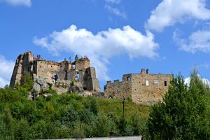
Kamieniec Castle is a 14th-century Gothic castle ruin, which was expanded in the 16th century expanded in a Renaissance form. The fortress is located on the borderlands between Korczyna and Odrzykoń in Krosno County, Podkarpackie Voivodeship, Poland.
Weather in this IP's area
overcast clouds
11 Celsius
10 Celsius
11 Celsius
11 Celsius
1005 hPa
73 %
1005 hPa
965 hPa
10000 meters
8.18 m/s
18.25 m/s
190 degree
100 %


