94.199.20.217 - IP Lookup: Free IP Address Lookup, Postal Code Lookup, IP Location Lookup, IP ASN, Public IP
Country:
Region:
City:
Location:
Time Zone:
Postal Code:
ISP:
ASN:
language:
User-Agent:
Proxy IP:
Blacklist:
IP information under different IP Channel
ip-api
Country
Region
City
ASN
Time Zone
ISP
Blacklist
Proxy
Latitude
Longitude
Postal
Route
db-ip
Country
Region
City
ASN
Time Zone
ISP
Blacklist
Proxy
Latitude
Longitude
Postal
Route
IPinfo
Country
Region
City
ASN
Time Zone
ISP
Blacklist
Proxy
Latitude
Longitude
Postal
Route
IP2Location
94.199.20.217Country
Region
nohiyahoi tobei jumhuri
City
hisor
Time Zone
Asia/Dushanbe
ISP
Language
User-Agent
Latitude
Longitude
Postal
ipdata
Country
Region
City
ASN
Time Zone
ISP
Blacklist
Proxy
Latitude
Longitude
Postal
Route
Popular places and events near this IP address

Hisar District (Tajikistan)
Distance: Approx. 934 meters
Latitude and longitude: 38.53333333,68.55
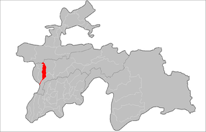
Hisar District (also transliterated as Hissar, Gissar) (Tajik: Ноҳияи Ҳисор, romanized: Nohiya‘i Hisor/Nohijaji Hisor) is a former district in the Region of Republican Subordination, in Tajikistan, located west of the capital Dushanbe, between Varzob District in the east and Shahrinav District in the west. Its capital Hisar is a town of 50,000 people about 10 km west of Dushanbe, at the center of the fertile Hisar Valley. Around 2018, the district was merged into the city of Hisar.

Hisar (Tajikistan)
Place in Districts of Republican Subordination, Tajikistan
Distance: Approx. 1151 meters
Latitude and longitude: 38.5264,68.5381
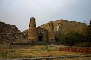
Hisor (Tajik: Ҳисор) or Hisar (Russian: Гиссар, Gissar) is a city in western Tajikistan, about 15 km west of Dushanbe. The city was the seat of the former Hisar District, and is part of the Districts of Republican Subordination. It lies at an altitude of 799–824 m, surrounded by high mountains (Gissar Range to the north, Babatag and Aktau ranges to the south).
Khanaka (river)
River in Tajikistan
Distance: Approx. 9857 meters
Latitude and longitude: 38.4425,68.5923
The Khanaka (Russian: Ханака, Tajik: Хонақоҳ Khonaqoh) is a river of western Tajikistan. A right tributary of the Kofarnihon, it passes through the town of Hisor.

Kugitang Svita
Geologic feature in Asia
Distance: Approx. 5081 meters
Latitude and longitude: 38.5,68.6
The Kugitang Formation or Group (Russian: Kugitang Svita) is an Oxfordian geologic formation in Tajikistan and Uzbekistan and a geologic group in Turkmenistan. Dinosaur remains diagnostic to the genus level are among the fossils that have been recovered from the formation.
Kurek Formation
Geologic formation in Uzbekistan
Distance: Approx. 5081 meters
Latitude and longitude: 38.5,68.6
The Kurek Formation (Russian: Kurek Svita) is a late Oxfordian (Late Jurassic) geologic formation of the Kugitang Svita in Turkmenistan and Uzbekistan. Fossil sauropod tracks have been reported from the formation.
Mirzo Rizo
Jamoat in Districts of Republican Subordination, Tajikistan
Distance: Approx. 8699 meters
Latitude and longitude: 38.56666667,68.46666667
Mirzo Rizo (Tajik: Мирзо Ризо, Russian: Мирза Реза) is a jamoat in Tajikistan. It is part of the city of Hisor in Districts of Republican Subordination.
Mirzo Tursunzoda, Hisor
Jamoat in Districts of Republican Subordination, Tajikistan
Distance: Approx. 3147 meters
Latitude and longitude: 38.51666667,68.51666667
Mirzo Tursunzoda (Tajik: Мирзо Турсунзода, Russian: Мирзо Турсунзаде, formerly Karamkul) is a jamoat in Tajikistan. It is part of the city of Hisor in Districts of Republican Subordination. The jamoat has a total population of 20,303 (2015).
Navobod, Hisor
Village and Jamoat in Districts of Republican Subordination, Tajikistan
Distance: Approx. 5528 meters
Latitude and longitude: 38.56666667,68.51666667
Navobod (Tajik: Навобод, Russian: Навобод) is a village and jamoat in Tajikistan. It is part of the city of Hisor in Districts of Republican Subordination. The jamoat has a total population of 26,321 (2015).
Durbat
Village and Jamoat in Districts of Republican Subordination, Tajikistan
Distance: Approx. 7212 meters
Latitude and longitude: 38.53333333,68.63333333
Durbat (Tajik: Дурбат, Russian: Дурбат) is a village and jamoat in Tajikistan. It is part of the city of Hisor in Districts of Republican Subordination. The jamoat has a total population of 20,052 (2015).
Dehqonobod
Village and Jamoat in Districts of Republican Subordination, Tajikistan
Distance: Approx. 3092 meters
Latitude and longitude: 38.55,68.56666667
Dehqonobod (Persian: دهقانآباد) is a village and jamoat in Tajikistan. It is part of the city of Hisor in Districts of Republican Subordination. The jamoat has a total population of 20,686 (2015).
Somon, Tajikistan
Jamoat in Districts of Republican Subordination, Tajikistan
Distance: Approx. 6494 meters
Latitude and longitude: 38.58333333,68.55
Somon (Tajik: Сомон, Russian: Сомон, formerly Khonaqoh) is a jamoat in Tajikistan. It is part of the city of Hisor in Districts of Republican Subordination. The jamoat has a total population of 28,691 (2015).
Hisor Central Stadium
Multi-purpose stadium in Hisor, Tajikistan
Distance: Approx. 2772 meters
Latitude and longitude: 38.54955444,68.5564725
The Hisor Central Stadium (Tajik: Варзишгохи марказии Ҳисор, romanized: Varzishgoxi markazii Hisor) is a multi-purpose stadium in Hisor, Tajikistan. It is currently used mostly for football matches. Ever since it opened in 2015, this stadium, which can hold 20,000 people, has been the home of football club Barkchi and the Tajikistan national football team.
Weather in this IP's area
few clouds
2 Celsius
-0 Celsius
2 Celsius
2 Celsius
1040 hPa
72 %
1040 hPa
917 hPa
10000 meters
1.86 m/s
1.83 m/s
37 degree
15 %