94.154.96.10 - IP Lookup: Free IP Address Lookup, Postal Code Lookup, IP Location Lookup, IP ASN, Public IP
Country:
Region:
City:
Location:
Time Zone:
Postal Code:
ISP:
ASN:
language:
User-Agent:
Proxy IP:
Blacklist:
IP information under different IP Channel
ip-api
Country
Region
City
ASN
Time Zone
ISP
Blacklist
Proxy
Latitude
Longitude
Postal
Route
db-ip
Country
Region
City
ASN
Time Zone
ISP
Blacklist
Proxy
Latitude
Longitude
Postal
Route
IPinfo
Country
Region
City
ASN
Time Zone
ISP
Blacklist
Proxy
Latitude
Longitude
Postal
Route
IP2Location
94.154.96.10Country
Region
wielkopolskie
City
nowy tomysl
Time Zone
Europe/Warsaw
ISP
Language
User-Agent
Latitude
Longitude
Postal
ipdata
Country
Region
City
ASN
Time Zone
ISP
Blacklist
Proxy
Latitude
Longitude
Postal
Route
Popular places and events near this IP address

Kreis Neutomischel
1887–1919 Prussian district
Distance: Approx. 461 meters
Latitude and longitude: 52.316667,16.133333
Kreis Neutomischel (Polish: Powiat nowotomyski) was a district in the southern administrative region of Posen, in the Prussian province of Posen from 1887 to 1919. It presently lies in the western part of Polish region of Greater Poland Voivodeship. The district was formed in 1887, when Kreis Buk was bifurcated.

Nowy Tomyśl
Town in Greater Poland Voivodeship, Poland
Distance: Approx. 461 meters
Latitude and longitude: 52.31666667,16.13333333
Nowy Tomyśl [ˈnɔvɨ ˈtɔmɨɕl] is a town in western Poland, in Greater Poland Voivodeship. It is the capital of Nowy Tomyśl County. The population is 15,627 (2004).

Nowy Tomyśl County
County in Greater Poland Voivodeship, Poland
Distance: Approx. 461 meters
Latitude and longitude: 52.31666667,16.13333333
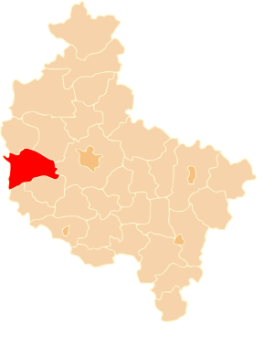
Nowy Tomyśl County (Polish: powiat nowotomyski) is a unit of territorial administration and local government (powiat) in Greater Poland Voivodeship, west-central Poland. It came into being on January 1, 1999, as a result of the Polish local government reforms passed in 1998. Its administrative seat and largest town is Nowy Tomyśl, which lies 55 kilometres (34 mi) west of the regional capital Poznań.
Gmina Nowy Tomyśl
Gmina in Greater Poland Voivodeship, Poland
Distance: Approx. 461 meters
Latitude and longitude: 52.31666667,16.13333333
Gmina Nowy Tomyśl is an urban-rural gmina (administrative district) in Nowy Tomyśl County, Greater Poland Voivodeship, in west-central Poland. Its seat is the town of Nowy Tomyśl, which lies approximately 55 kilometres (34 mi) west of the regional capital Poznań. The gmina covers an area of 185.89 square kilometres (71.8 sq mi), and as of 2006 its total population is 24,237 (out of which the population of Nowy Tomyśl amounts to 15,225, and the population of the rural part of the gmina is 9,012).
Chojniki, Greater Poland Voivodeship
Village in Greater Poland Voivodeship, Poland
Distance: Approx. 2313 meters
Latitude and longitude: 52.3,16.11666667
Chojniki [xɔi̯ˈniki] is a village in the administrative district of Gmina Nowy Tomyśl, within Nowy Tomyśl County, Greater Poland Voivodeship, in west-central Poland. It lies approximately 3 kilometres (2 mi) south-west of Nowy Tomyśl and 56 km (35 mi) west of the regional capital Poznań.
Glinno, Nowy Tomyśl County
Village in Greater Poland Voivodeship, Poland
Distance: Approx. 1735 meters
Latitude and longitude: 52.33333333,16.11666667
Glinno [ˈɡlinnɔ] is a village in the administrative district of Gmina Nowy Tomyśl, within Nowy Tomyśl County, Greater Poland Voivodeship, in west-central Poland. It lies approximately 3 kilometres (2 mi) north-west of Nowy Tomyśl and 55 km (34 mi) west of the regional capital Poznań.

Jastrzębsko Stare
Village in Greater Poland Voivodeship, Poland
Distance: Approx. 4729 meters
Latitude and longitude: 52.3,16.06666667
Jastrzębsko Stare [jasˈtʂɛmpskɔ ˈstarɛ] is a village in the administrative district of Gmina Nowy Tomyśl, within Nowy Tomyśl County, Greater Poland Voivodeship, in west-central Poland. It lies approximately 5 kilometres (3 mi) west of Nowy Tomyśl and 59 km (37 mi) west of the regional capital Poznań.
Paproć, Greater Poland Voivodeship
Village in Greater Poland Voivodeship, Poland
Distance: Approx. 2197 meters
Latitude and longitude: 52.3,16.13333333
Paproć [ˈpaprɔt͡ɕ] is a village in the administrative district of Gmina Nowy Tomyśl, within Nowy Tomyśl County, Greater Poland Voivodeship, in west-central Poland. It lies approximately 2 kilometres (1 mi) south of Nowy Tomyśl and 55 km (34 mi) west of the regional capital Poznań. The Nowy Tomyśl Wind Turbines, two of the tallest in the world, are nearby.
Przyłęk, Greater Poland Voivodeship
Village in Greater Poland Voivodeship, Poland
Distance: Approx. 1735 meters
Latitude and longitude: 52.33333333,16.11666667
Przyłęk [ˈpʂɨwɛnk] is a village in the administrative district of Gmina Nowy Tomyśl, within Nowy Tomyśl County, Greater Poland Voivodeship, in west-central Poland. It lies approximately 3 kilometres (2 mi) north-west of Nowy Tomyśl and 55 km (34 mi) west of the regional capital Poznań.
Sękowo, Nowy Tomyśl County
Village in Greater Poland Voivodeship, Poland
Distance: Approx. 3298 meters
Latitude and longitude: 52.30361111,16.0875
Sękowo [sɛnˈkɔvɔ] is a village in the administrative district of Gmina Nowy Tomyśl, within Nowy Tomyśl County, Greater Poland Voivodeship, in west-central Poland.

Stary Tomyśl
Village in Greater Poland Voivodeship, Poland
Distance: Approx. 4278 meters
Latitude and longitude: 52.35,16.16666667
Stary Tomyśl [ˈstarɨ ˈtɔmɨɕl] is a village in the administrative district of Gmina Nowy Tomyśl, within Nowy Tomyśl County, Greater Poland Voivodeship, in west-central Poland. It lies approximately 5 kilometres (3 mi) north-east of Nowy Tomyśl and 52 km (32 mi) west of the regional capital Poznań.
Nowy Tomyśl Wind Turbines
Distance: Approx. 3232 meters
Latitude and longitude: 52.2947,16.1531
The Nowy Tomyśl Wind Turbines are wind turbines which used to be the tallest in the world. They are situated in Paproć, a village near Nowy Tomyśl in Poland and were erected in 2012. Each of these two wind turbines has a generating capacity of 2500 kW. Both rotors have a diameter of 100 metres and are mounted on 160 metre tall free-standing lattice towers, which are the tallest free-standing lattice towers in Poland.
Weather in this IP's area
few clouds
5 Celsius
3 Celsius
5 Celsius
5 Celsius
1037 hPa
75 %
1037 hPa
1026 hPa
10000 meters
2.53 m/s
4.72 m/s
256 degree
12 %


