94.154.13.48 - IP Lookup: Free IP Address Lookup, Postal Code Lookup, IP Location Lookup, IP ASN, Public IP
Country:
Region:
City:
Location:
Time Zone:
Postal Code:
ISP:
ASN:
language:
User-Agent:
Proxy IP:
Blacklist:
IP information under different IP Channel
ip-api
Country
Region
City
ASN
Time Zone
ISP
Blacklist
Proxy
Latitude
Longitude
Postal
Route
db-ip
Country
Region
City
ASN
Time Zone
ISP
Blacklist
Proxy
Latitude
Longitude
Postal
Route
IPinfo
Country
Region
City
ASN
Time Zone
ISP
Blacklist
Proxy
Latitude
Longitude
Postal
Route
IP2Location
94.154.13.48Country
Region
satakunta
City
nakkila
Time Zone
Europe/Helsinki
ISP
Language
User-Agent
Latitude
Longitude
Postal
ipdata
Country
Region
City
ASN
Time Zone
ISP
Blacklist
Proxy
Latitude
Longitude
Postal
Route
Popular places and events near this IP address

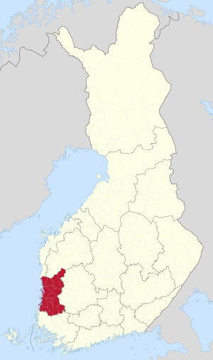
Satakunta
Region of Finland
Distance: Approx. 3714 meters
Latitude and longitude: 61.33333333,22
Satakunta (in both Finnish and Swedish, Finnish pronunciation: [ˈs̠ɑt̪ɑˌkun̪t̪ɑ]; historically Satacundia) is a region (maakunta / landskap) of Finland, part of the former Western Finland Province. It borders the regions of Southwest Finland, Pirkanmaa, South Ostrobothnia and Ostrobothnia. The capital city of the region is Pori.

Harjavalta
Town in Satakunta, Finland
Distance: Approx. 9050 meters
Latitude and longitude: 61.31666667,22.13361111
Harjavalta (Finnish pronunciation: [ˈhɑrjɑˌʋɑltɑ]) is a town and municipality in Finland. It's located in the Satakunta region, 29 kilometres (18 mi) southeast of Pori. The town has a population of 6,650 (31 December 2024) and covers an area of 127.74 square kilometres (49.32 sq mi) of which 4.28 km2 (1.65 sq mi) is water.

Nakkila
Municipality in Satakunta, Finland
Distance: Approx. 369 meters
Latitude and longitude: 61.36472222,22.00555556
Nakkila (Finnish pronunciation: [ˈnɑkːilɑ]) is a municipality of Finland. It is located in the province of Western Finland and is part of the Satakunta region, 19 kilometres (12 mi) southeast of Pori. The Kokemäki River flows along the center of Nakkila.

Ulvila
Town in Satakunta, Finland
Distance: Approx. 9133 meters
Latitude and longitude: 61.43333333,21.9
Ulvila (Finnish: [ˈulʋilɑ]; Swedish: Ulvsby) is a town and municipality of Finland. It is one of the six medieval cities of Finland, as well as the third oldest city in the country. Ulvila was granted charter as a town by King Albert of Sweden on 7 February 1365.

Vanhakylä
District of Ulvila, Finland
Distance: Approx. 9369 meters
Latitude and longitude: 61.43488889,21.89694444
Vanhakylä (Swedish: Gammalby, lit. 'Old Village') or Vanha-Ulvila (lit. 'Old Ulvila') is a district of Ulvila in the Pori sub-region of Satakunta in southwestern Finland. The Kokemäenjoki divides the town centre of Ulvila into two parts – Vanhakylä constitutes the eastern half, on the northern bank of the Kokemäenjoki, and the western half is the district of Friitala, on the river's southern bank. The medieval town of Ulvila was located in the modern district of Vanhakylä, from which the district's name is derived.

Nakkila Church
Church in Nakkila, Finland
Distance: Approx. 240 meters
Latitude and longitude: 61.36777778,22.00388889
Nakkila Church is a Functionalist-style Lutheran church in Nakkila, Finland. It was completed in 1937 by the design of the architect Erkki Huttunen. Along with the churches of Kannonkoski, Rajamäki and Varkaus and the Lakeuden Risti Church, it is considered as one of the most significant examples of Modernist churches in Finland.

Villilä Manor
Building in Nakkila, Finland
Distance: Approx. 573 meters
Latitude and longitude: 61.36158,22.00105
Villilä manor (Fin: Villilän kartano) is a manor in Nakkila. It is located right next to central Nakkila, close to valtatie 2 and the Tampere-Pori railway. Villilä studios have been operating in the next to the manor since 2003.
Weather in this IP's area
clear sky
3 Celsius
-1 Celsius
3 Celsius
3 Celsius
999 hPa
87 %
999 hPa
995 hPa
10000 meters
5.14 m/s
220 degree