Country:
 Denmark
Region:
City:
Latitude and Longitude:
Time Zone:
Postal Code:
IP information under different IP Channel
ip-api
Country
Region
City
ASN
Time Zone
ISP
Blacklist
Proxy
Latitude
Longitude
Postal
Route
IPinfo
Country
Region
City
ASN
Time Zone
ISP
Blacklist
Proxy
Latitude
Longitude
Postal
Route
MaxMind
Country
Region
City
ASN
Time Zone
ISP
Blacklist
Proxy
Latitude
Longitude
Postal
Route
Luminati
Country
DKRegion
85
City
koge
ASN
Time Zone
Europe/Copenhagen
ISP
Telenor A/S
Latitude
Longitude
Postal
db-ip
Country
Region
City
ASN
Time Zone
ISP
Blacklist
Proxy
Latitude
Longitude
Postal
Route
ipdata
Country
Region
City
ASN
Time Zone
ISP
Blacklist
Proxy
Latitude
Longitude
Postal
Route
Popular places and events near this IP address

Køge railway station
Railway station in Køge, Denmark
Distance: Approx. 1000 meters
Latitude and longitude: 55.45777778,12.18666667
Køge station is the principal railway station serving the town of Køge 39 km southwest of Copenhagen on the island of Zealand, Denmark. It is located in central Køge, situated between the historic town centre and the Port of Køge, and immediately adjacent to the Køge bus station. The station is located on the Little South Line between Roskilde and Næstved via Køge, and is the terminus of an S-train line (Køgebugtbanen) that connects it to Copenhagen, and Østbanen that connects it with the Stevns Peninsula.
Køge Huskors
Witch trial in Denmark
Distance: Approx. 1235 meters
Latitude and longitude: 55.45671,12.18267
Køge Huskors was the name for a witch trial in the city of Køge in Denmark, which took place in 1608–1615. It is one of the best known witch trials in Denmark. It led to the execution of between fifteen and twenty women by burning at the stake.

Køge
Town in Zealand, Denmark
Distance: Approx. 1419 meters
Latitude and longitude: 55.45611111,12.17972222
Køge (Danish pronunciation: [ˈkʰøː(j)ə], older spelling Kjøge) is a seaport on the coast of Køge Bugt (Bay of Køge) 39 km southwest of Copenhagen. It is the principal town and seat of Køge Municipality, Region Sjælland, Denmark. In 2024, the urban area had a population of 38,647.
Battle of Køge
1807 battle during the Napoleonic Wars
Distance: Approx. 1419 meters
Latitude and longitude: 55.45611111,12.17972222
The Battle of Køge was a battle on 29 August 1807 between British troops besieging Copenhagen and Danish militia raised on Sjælland. It ended in British victory and is also known as 'Træskoslaget' or 'the Clogs Battle', since many of the Danish militiamen threw their heavy wooden clogs away when they were fleeing.

Køge Å
River in Denmark
Distance: Approx. 682 meters
Latitude and longitude: 55.45,12.2
Køge Å is a 20.6 km long stream or small river which drains into the Bay of Køge in central Køge, on the east coast of Zealand, some 40 km south of Copenhagen, Denmark. The stream originates in the area south of the protected Regnemarks Mose boglands and is 10 metres wide at its mouth. A 22 km gravel road for cyclists and pedestrians follows the stream from the town of Køge to Humleore on onwards to Borup station.

Norske Løve, Køge
Distance: Approx. 1222 meters
Latitude and longitude: 55.46057222,12.18460278
Norske Løve is a former mail and coaching inn in Køge, Denmark. It takes its name after the naval ship commanded by Niels Juel in the Battle of Køge Bay in 1677. The main wing from 1801-1811 is listed.
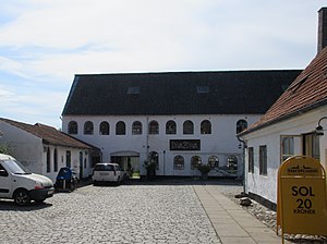
Køge Iron Foundry
Distance: Approx. 1545 meters
Latitude and longitude: 55.45746667,12.17786389
Køge Iron Foundry (Danish: Køge Jernstøberi) is a former iron foundry situated in Vestergade in Køge, Denmark. The complex consists of a residential building fronting the street and a factory building and various lower buildings in two successive courtyards to its rear. The residential building, the factory building and a side wing are listed.
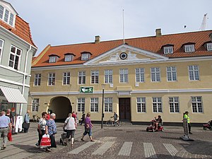
Køge Town Hall
Building in Køge, Denmark
Distance: Approx. 1224 meters
Latitude and longitude: 55.45655,12.18283
Køge Town Hall is located in the central town square of Køge, Denmark. The building dates from the 16th century but was adapted in the Neoclassical style in 1903.

Garvergården
Danish building
Distance: Approx. 1415 meters
Latitude and longitude: 55.45671111,12.17982222
Garvergården (lit. "The Tanner's House") is a half-timbered building complex from circa 1600 situated in Vestergade in Køge, Denmark. Owned by shoemakers and tanners for almost 200 years, from 1732, until the early 1920s, it bears testament to a time when Køge was a centre for shoemaking and tanning.

Tøxen's School
School building in Køge, Denmark
Distance: Approx. 1241 meters
Latitude and longitude: 55.46012222,12.18393611
Tøxen's School (Danish: Tøxens Skole) is a former school in Køge, Denmark. Its building from 1859 in Nørregade is listed.

KØS Museum of art in public spaces
Distance: Approx. 1227 meters
Latitude and longitude: 55.458828,12.183414
KØS Museum of art in public spaces is situated in Nørregade in Køge, Denmark. It is the only museum in Denmark focusing of art in the public realm. It boasts a collection of models and sketches for public artworks and plays host to special exhibitions about the subject.

Køge Pharmacy
Historic building in Køge, Denmark
Distance: Approx. 1249 meters
Latitude and longitude: 55.45583333,12.18241667
Køge Pharmacy (Danish: Køge Apotek) was founded in 1646 and is located just off the central market square in Køge, Denmark. The buildings are originally from the 1660s but the main building was altered in circa 1800 and again in 1865. A long, half-timbered building extends from the rear side of the pharmacy.
Weather in this IP's area
broken clouds
9 Celsius
7 Celsius
9 Celsius
10 Celsius
1013 hPa
82 %
1013 hPa
1013 hPa
10000 meters
4.12 m/s
230 degree
75 %
07:33:49
18:21:34