Country:
Region:
City:
Latitude and Longitude:
Time Zone:
Postal Code:
IP information under different IP Channel
ip-api
Country
Region
City
ASN
Time Zone
ISP
Blacklist
Proxy
Latitude
Longitude
Postal
Route
Luminati
Country
Region
wal
City
gembloux
ASN
Time Zone
Europe/Brussels
ISP
VERIXI SA
Latitude
Longitude
Postal
IPinfo
Country
Region
City
ASN
Time Zone
ISP
Blacklist
Proxy
Latitude
Longitude
Postal
Route
db-ip
Country
Region
City
ASN
Time Zone
ISP
Blacklist
Proxy
Latitude
Longitude
Postal
Route
ipdata
Country
Region
City
ASN
Time Zone
ISP
Blacklist
Proxy
Latitude
Longitude
Postal
Route
Popular places and events near this IP address

Chastre
Municipality in French Community, Belgium
Distance: Approx. 6107 meters
Latitude and longitude: 50.6,4.63333333
Chastre (French pronunciation: [ʃastʁ]; Walloon: Tchåsse, Walloon pronunciation: [t͡ʃɔːs]) is a French-speaking municipality in Belgium that is located in Wallonia, in the province of Walloon Brabant. Its name comes from the Gallo-Roman word castra "fortress, fortified camp", from the Latin castra which is the plural form of castrum meaning "entrenchment, fortified place". Chastre is a rural and at the same time residential municipality, with 7,684 inhabitants.

Gembloux
Municipality in Namur Province, Belgium
Distance: Approx. 1011 meters
Latitude and longitude: 50.56666667,4.68333333
Gembloux (French: [ʒɑ̃blu] ; Walloon: Djiblou; Dutch: Gembloers [ˈɣɛmbluːrs]) is a city and municipality of Wallonia located in the province of Namur, Belgium. On 1 January 2006, the municipality had 21,964 inhabitants. The total area is 95.86 km2, yielding a population density of 229 inhabitants per km2.

Bothey
Village in Wallonia, Belgium
Distance: Approx. 5395 meters
Latitude and longitude: 50.52177778,4.65272222
Bothey (Walloon: Bôtè) is a village of Wallonia and a district of the municipality of Gembloux, located in the province of Namur, Belgian. Bothey was its own municipality until the fusion of the Belgian municipalities in 1977 when it merged with Gembloux.

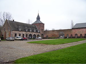
Gembloux Abbey
Distance: Approx. 61 meters
Latitude and longitude: 50.562286,4.694882
Gembloux Abbey (French: Abbaye de Gembloux) was a Benedictine abbey near Gembloux in the province of Namur, Wallonia, Belgium. Since 1860, its buildings host the University of Liège's Gembloux Agro-Bio Tech faculty and campus (previously known as Agronomical University of Gembloux).

Gembloux Agro-Bio Tech
Faculty of the University of Liège, Belgium
Distance: Approx. 57 meters
Latitude and longitude: 50.5623,4.696
Gembloux Agro-Bio Tech (GxABT), located in Gembloux, Belgium, is one of the eleven faculties of the University of Liège. Founded in 1860 and previously known as the Faculté universitaire des sciences agronomiques de Gembloux (FUSAGx, French for: Gembloux Agronomical University), it is Belgium's oldest educational and research institution dedicated to agronomic sciences and biological engineering. It is the only school in Belgium to be accredited by the French Commission des Titres d'Ingénieur allowing the university to deliver the Diplôme d'Ingénieur engineering degree.

Château de Corroy-le-Château
Distance: Approx. 4273 meters
Latitude and longitude: 50.5328,4.6561
The Castle of Corroy-le-Château (French: Château de Corroy-le-Château) is a medieval castle in the village of Corroy-le-Château, near Gembloux, in the province of Namur, Wallonia, Belgium. Originally built between 1220 and 1230 by William of Brabant, the castle is one of the best-preserved medieval buildings in Belgium, with gigantic round towers and a moat.

Battle of Gembloux (1940)
Battle during World War II
Distance: Approx. 4726 meters
Latitude and longitude: 50.6,4.666
The Battle of Gembloux (or Battle of the Gembloux Gap) was fought between French and German forces in May 1940 during the Second World War. On 10 May 1940, The Nazi Wehrmacht, invaded Luxembourg, The Netherlands and Belgium under the operational plan Fall Gelb (Case Yellow). Allied armies responded with the Dyle Plan (Breda variant), intended to halt the Germans in Belgium, believing it to be the main German thrust.
Golzinne
Hamlet in Belgium
Distance: Approx. 4961 meters
Latitude and longitude: 50.51918889,4.71553056
Golzinne is a hamlet of the village of Bossière in Wallonia. It is administratively part of the city of Gembloux, located in the province of Namur, Belgium. It is notable as the only current producer of "Noir de Golzinne", a black marble.

Gembloux railway station
Railway station in Namur, Belgium
Distance: Approx. 1018 meters
Latitude and longitude: 50.57055556,4.69083333
Gembloux railway station (French: Gare de Gembloux; Dutch: Station Gembloers) is a railway station in Gembloux, Namur, Belgium. The station was opened on 14 June 1855 by the Grande Compagnie de Luxembourg on railway lines 144, 147 and 161. It is operated by the National Railway Company of Belgium (SNCB/NMBS).

Mazy
Village in Wallonia, Belgium
Distance: Approx. 5772 meters
Latitude and longitude: 50.51144444,4.67669444
Mazy (Walloon: Mazi) is a village of Wallonia and a district of the municipality of Gembloux, located in the province of Namur, Belgium.
Ligny (river)
River in Belgium
Distance: Approx. 6614 meters
Latitude and longitude: 50.50478,4.66975
The Ligny is a stream in Belgium, a tributary of the Orneau on the right bank. Its waters eventually join the Meuse via the Sambre.

Lonzée
Area of Gembloux, Belgium
Distance: Approx. 2378 meters
Latitude and longitude: 50.55305556,4.72611111
Lonzée (French pronunciation: [lɔ̃ze]; Walloon: Lonzêye) is a village of Wallonia and a district of the municipality of Gembloux, located in the province of province of Namur, Belgium. It was a municipality in its own right until the fusion of the Belgian municipalities in 1945. The village is located in Hesbaye and extends along the Arton (a stream that is a tributary of the Orneau).
Weather in this IP's area
clear sky
7 Celsius
5 Celsius
6 Celsius
7 Celsius
1023 hPa
91 %
1023 hPa
1005 hPa
10000 meters
2.32 m/s
3.55 m/s
194 degree
2 %
07:39:33
17:10:04