Country:
 Netherlands
Region:
City:
Latitude and Longitude:
Time Zone:
Postal Code:
IP information under different IP Channel
ip-api
Country
Region
City
ASN
Time Zone
ISP
Blacklist
Proxy
Latitude
Longitude
Postal
Route
IPinfo
Country
Region
City
ASN
Time Zone
ISP
Blacklist
Proxy
Latitude
Longitude
Postal
Route
MaxMind
Country
Region
City
ASN
Time Zone
ISP
Blacklist
Proxy
Latitude
Longitude
Postal
Route
Luminati
Country
NLASN
Time Zone
Europe/Amsterdam
ISP
CLDIN B.V.
Latitude
Longitude
Postal
db-ip
Country
Region
City
ASN
Time Zone
ISP
Blacklist
Proxy
Latitude
Longitude
Postal
Route
ipdata
Country
Region
City
ASN
Time Zone
ISP
Blacklist
Proxy
Latitude
Longitude
Postal
Route
Popular places and events near this IP address
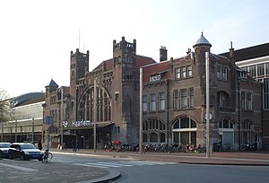
Haarlem railway station
Railway station in Haarlem, Netherlands
Distance: Approx. 1608 meters
Latitude and longitude: 52.38777778,4.63888889
Haarlem railway station is located in Haarlem in North Holland, Netherlands. The station opened at September 20, 1839, on the Amsterdam–Rotterdam railway, the first railway line in the Netherlands. The station building itself is a rijksmonument.

Hofje van Noblet
Hofje in Haarlem, Netherlands
Distance: Approx. 1679 meters
Latitude and longitude: 52.385,4.64222222
The Hofje van Noblet is a hofje in Haarlem, Netherlands.

Hofje van Staats
Hofje in Haarlem, Netherlands
Distance: Approx. 1668 meters
Latitude and longitude: 52.38611111,4.64027778
The Hofje van Staats is a hofje in Haarlem, Netherlands, on the Jansweg 39, close to the Haarlem railway station.

Huis ter Kleef
Former castle in Haarlem, Netherlands
Distance: Approx. 1497 meters
Latitude and longitude: 52.396,4.635
The ruins of the Huis ter Kleef castle are located in the city gardens of Haarlem.
Haarlem Stadion
Distance: Approx. 1566 meters
Latitude and longitude: 52.41027778,4.64888889
Haarlem Stadion (Dutch pronunciation: [ˈɦaːrlɛm ˌstaːdijɔn]) is a stadium in Haarlem, Netherlands, and the home stadium of the Dutch amateur football club Haarlem Kennemerland. Formerly home of the defunct professional football club HFC Haarlem, the stadium is located in the north of Haarlem. It was built in 1907, with renovations in 1947 and during the eighties, including the replacement of the south stand, which is an all-seater stand.

Penningsveer
Town in North Holland, Netherlands
Distance: Approx. 1386 meters
Latitude and longitude: 52.39277778,4.67611111
Penningsveer is a town in the Dutch province of North Holland. It is a part of the municipality of Haarlemmermeer and lies about 3 km (1.9 mi) east of Haarlem. The town is named after the ferry (Dutch:veer) that (for a penny) used to take travellers across the Liede.

Schoten, North Holland
Distance: Approx. 1472 meters
Latitude and longitude: 52.40694444,4.6425
Schoten (Dutch pronunciation: [ˈsxoːtə(n)] ) is a former village in the Dutch province of North Holland. It was located between Haarlem and Santpoort. Schoten was a separate municipality between 1817 and 1927, when it was merged with Haarlem.

Museum van de Geest
Psychiatry museum in the Netherlands
Distance: Approx. 1509 meters
Latitude and longitude: 52.39027778,4.63777778
Museum van de Geest ("Museum of the Mind") was created in 2020 when Het Dolhuys ("The Madhouse"), the national museum for psychiatry in Haarlem, the Netherlands, merged with the Outsider Art Museum from Amsterdam. Het Dolhuys had been founded in 2005 in the newly renovated former old-age home known as Schoterburcht, located just across the Schotersingel from the Staten Bolwerk park. The whole Het Dolhuys complex is much older, having for centuries been a hospital known as the Leproos-, Pest- en Dolhuys (Leper, Plague, and Mad House).
EvoSwitch
Dutch internet service provider
Distance: Approx. 809 meters
Latitude and longitude: 52.39162222,4.66480278
EvoSwitch is part of the Ocom Group, based in Amsterdam and described as Europe's largest privately owned Internet service provider.

Koepelgevangenis (Haarlem)
Former prison in Haarlem, Netherlands
Distance: Approx. 1674 meters
Latitude and longitude: 52.3836,4.6461
The Koepelgevangenis is a former prison in Haarlem, Netherlands. It is one of three Panopticon-style buildings situated in the country. One of three designed by Willem Metzelaar, the building was completed in 1901.

Schoterveense Molen, Haarlem
Distance: Approx. 1705 meters
Latitude and longitude: 52.39803056,4.63191667
Schoterveense Molen is a windmill in Haarlem located at Wipwatermolen Heussensstraat in the former municipality of Schoten. It is registered as a Rijksmonument. This windmill stands as silent witness to the heritage of a defunct organization called Waterschap De Schoterveenpolder, that ended in 1935.

Barrel Organ Museum Haarlem
Music instrument museum in Küppersweg, Haarlem
Distance: Approx. 730 meters
Latitude and longitude: 52.39093861,4.65327056
Barrel Organ Museum Haarlem (Dutch: Draaiorgelmuseum Haarlem) is a museum in Haarlem in the Netherlands. Next to the presentation of a variety of barrel organs, accessory objects and documentation material, there is a ballroom where music of the organs is being played. The museum was opened in 1969 by the foundation Het Kunkels Orgel.
Weather in this IP's area
broken clouds
14 Celsius
14 Celsius
13 Celsius
15 Celsius
1016 hPa
96 %
1016 hPa
1016 hPa
8000 meters
4.12 m/s
170 degree
75 %
08:15:53
18:36:00