Country:
Region:
City:
Latitude and Longitude:
Time Zone:
Postal Code:
IP information under different IP Channel
ip-api
Country
Region
City
ASN
Time Zone
ISP
Blacklist
Proxy
Latitude
Longitude
Postal
Route
Luminati
Country
Region
bru
City
brussels
ASN
Time Zone
Europe/Brussels
ISP
Orange Belgium SA
Latitude
Longitude
Postal
IPinfo
Country
Region
City
ASN
Time Zone
ISP
Blacklist
Proxy
Latitude
Longitude
Postal
Route
db-ip
Country
Region
City
ASN
Time Zone
ISP
Blacklist
Proxy
Latitude
Longitude
Postal
Route
ipdata
Country
Region
City
ASN
Time Zone
ISP
Blacklist
Proxy
Latitude
Longitude
Postal
Route
Popular places and events near this IP address
Brussels Independent Film Festival
Belgian film festival founded in 1974
Distance: Approx. 323 meters
Latitude and longitude: 50.82931944,4.34455
The Brussels Independent Film Festival, previously known as the Brussels International Independent Film Festival, or le Festival International du Film Indépendant de Bruxelles, has taken place since 1974. It originally focused on Super 8 films, and today is a showcase for many kinds of independent films. The festival has hosted filmmakers such as Pedro Almodovar, François Ozon, and Nanni Moretti.

Horta Museum
Historic Art Nouveau house and UNESCO World Heritage Site in Brussels, Belgium
Distance: Approx. 594 meters
Latitude and longitude: 50.82416667,4.35472222
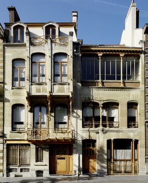
The Horta Museum (French: Musée Horta; Dutch: Hortamuseum) is a museum in Brussels, Belgium, dedicated to the life and work of the architect Victor Horta and his time. The museum is housed in Horta's former town house and workshop (French: Maison et Atelier Horta, Dutch: Woning en Atelier Horta), built between 1898 and 1901, in Art Nouveau style. It is located at 23–25, rue Américaine/Amerikaansestraat in the municipality of Saint-Gilles.

Fortifications of Brussels
Former city walls in Brussels, Belgium
Distance: Approx. 658 meters
Latitude and longitude: 50.833,4.345
The Fortifications of Brussels (French: Fortifications de Bruxelles; Dutch: Vestingwerken van Brussel) refers to the medieval city walls that surrounded Brussels, Belgium, built primarily to defend the city but also for administrative reasons. There were two stages of fortifications of Brussels: the first walls, built in the early 13th century, and the second walls, built in the late 14th century and later upgraded. In the 19th century, the second walls were torn down and replaced with the Small Ring, a series of boulevards bounding the historical city centre.

Halle Gate
Former city gate and current museum in Brussels, Belgium
Distance: Approx. 670 meters
Latitude and longitude: 50.83305556,4.34472222
The Halle Gate (French: Porte de Hal, pronounced [pɔʁt də al]; Dutch: Hallepoort) is a former medieval city gate and the last vestige of the second walls of Brussels, Belgium. Built between 1381 and 1383, it was heavily restored in the 19th century in its current neo-Gothic style by the architect Henri Beyaert. It is now a museum dedicated to the medieval City of Brussels, part of the Royal Museums of Art and History (RMAH).

Hôtel des Monnaies metro station
Metro station in Brussels, Belgium
Distance: Approx. 668 meters
Latitude and longitude: 50.83333333,4.34944444
Hôtel des Monnaies (French) or Munthof (Dutch) is a Brussels Metro station on the southern segment of lines 2 and 6. It is located under the Small Ring (Brussels' inner ring road), near Saint Peter's Hospital, in the municipality of Saint-Gilles, south of the City of Brussels, Belgium. One of its entrances is on the Rue de l'Hôtel des Monnaies/Munthofstraat, after which it is named, and where Belgian currency used to be minted.
Institut Saint-Luc
Arts school in Brussels
Distance: Approx. 302 meters
Latitude and longitude: 50.825,4.35
The Institut Saint-Luc (French: [ɛ̃s.ti.ty sɛ̃.lyk]) is an arts school in Brussels, Belgium. It consists of six departments, with a total of 2,200 students and 430 employees, spread over five locations in Ixelles and Saint-Gilles.

Chaussée de Charleroi
Thoroughfare in Brussels, Belgium
Distance: Approx. 548 meters
Latitude and longitude: 50.82861111,4.35555556
The Chaussée de Charleroi (French: [ʃo.se d(ə) ʃaʁ.lə.ʁwa]) or Charleroisesteenweg (Dutch) is a major street in Brussels, Belgium, running through the municipalities of Saint-Gilles and the City of Brussels. It connects the Place Stéphanie/Stefanieplein in the City of Brussels to the Ma Campagne crossroad in Saint-Gilles. It forms the N261 road with the Avenue Brugmann/Brugmannlaan, the Rue de Stalle/Stallestraat and the Rue Prolongée de Stalle/Verlengde Stallestraat.

Horta premetro station
Premetro station in Brussels, Belgium
Distance: Approx. 212 meters
Latitude and longitude: 50.8261,4.3458
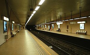
Horta is a premetro (underground tram) station located under the Chaussée de Waterloo/Waterloosesteenweg in the Saint-Gilles municipality of Brussels, Belgium. The station is named after the Art Nouveau architect Victor Horta, who designed a number of significant buildings in the area. It opened on 3 December 1993.

Parvis de Saint-Gilles premetro station
Premetro station in Brussels, Belgium
Distance: Approx. 400 meters
Latitude and longitude: 50.830556,4.3452778
Parvis de Saint-Gilles (French) or Sint-Gillisvoorplein (Dutch) is a premetro (underground tram) station located in the Saint-Gilles municipality of Brussels, Belgium. The main entrance is from the Parvis de Saint-Gilles/Sint-Gillisvoorplein, after which it is named. It opened on 3 December 1993.

Hôtel Goblet d'Alviella
Hôtel particulier in Brussels, Belgium
Distance: Approx. 632 meters
Latitude and longitude: 50.82888889,4.35666667
The Hôtel Goblet d'Alviella (French: Hôtel Goblet d'Alviella, Dutch: Huis Goblet d'Alviella) is a hôtel particulier designed by Octave van Rysselberghe on the Rue Faider/Faiderstraat in Saint-Gilles, Brussels, Belgium. It is the first major realization by Van Rysselberghe, who himself lived here until 1888. After that, the client, Count Eugène Goblet d'Alviella, professor, liberal member of parliament and freemason, moved in.
Saint-Gilles Prison
Prison in Brussels, Belgium
Distance: Approx. 670 meters
Latitude and longitude: 50.82138889,4.3475
Saint-Gilles Prison (French: Prison de Saint-Gilles, Dutch: Gevangenis van Sint-Gillis) is a prison in Brussels, Belgium, that opened in 1884. It is located on the borders of the municipalities of Saint-Gilles, Ixelles and Forest, next to Forest Prison and Berkendael Prison. Representative of the cellular system established during the 19th century, Saint-Gilles Prison was for a long time emblematic of overcrowding in Belgian prisons.

Saint-Gilles Municipal Hall
Municipal hall building in Saint-Gilles, Belgium
Distance: Approx. 363 meters
Latitude and longitude: 50.82444444,4.34583333
The Municipal Hall (French: Hôtel communal; Dutch: Gemeentehuis) of Saint-Gilles is the municipal hall building and the seat of that municipality of Brussels, Belgium. Designed by the architect Albert Dumont in neo-Flemish Renaissance style and completed in 1904, it is located at 39, place Maurice Van Meenen/Maurice Van Meenenplein. This site is served by the premetro (underground tram) station Horta on lines 3 and 4, as well as the tram stop Lombardie/Lombardije (on lines 81 and 97).
Weather in this IP's area
mist
8 Celsius
8 Celsius
7 Celsius
9 Celsius
1029 hPa
95 %
1029 hPa
1022 hPa
2400 meters
0.51 m/s
90 degree
100 %
07:43:26
17:09:04
