Country:
Region:
City:
Latitude and Longitude:
Time Zone:
Postal Code:
IP information under different IP Channel
ip-api
Country
Region
City
ASN
Time Zone
ISP
Blacklist
Proxy
Latitude
Longitude
Postal
Route
Luminati
Country
Region
nb
City
elst
ASN
Time Zone
Europe/Amsterdam
ISP
Eurofiber Nederland BV
Latitude
Longitude
Postal
IPinfo
Country
Region
City
ASN
Time Zone
ISP
Blacklist
Proxy
Latitude
Longitude
Postal
Route
db-ip
Country
Region
City
ASN
Time Zone
ISP
Blacklist
Proxy
Latitude
Longitude
Postal
Route
ipdata
Country
Region
City
ASN
Time Zone
ISP
Blacklist
Proxy
Latitude
Longitude
Postal
Route
Popular places and events near this IP address

Valkenburg aan de Geul
Municipality in Limburg, Netherlands
Distance: Approx. 292 meters
Latitude and longitude: 50.865,5.83111111
Valkenburg aan de Geul (Dutch: [ˈvɑlkə(m)bʏr(ə)x aːn də ˈɣøːl] ; Limburgish: Valkeberg [ˈvɑl˦əkəˌbæʀ˦əx] ) is a municipality situated in the southeastern Dutch province of Limburg. The name refers to the central town in the municipality, Valkenburg, and the small river Geul passing through it.
Houthem, Netherlands
Village in Limburg, Netherlands
Distance: Approx. 1913 meters
Latitude and longitude: 50.86666667,5.8
Houthem is a village in the Dutch province of Limburg. It is a part of the municipality of Valkenburg aan de Geul, and lies about 8 km east of Maastricht.

Cauberg
Distance: Approx. 593 meters
Latitude and longitude: 50.86106111,5.82368056
The Cauberg is a hill in Valkenburg aan de Geul, a town in the South Limburg region of the Netherlands. The hill played an important role in the early development of tourism in Valkenburg. Today, several major tourist attractions are situated on or nearby Cauberg.

Valkenburg Castle
Ruined castle in Valkenburg aan de Geul, Netherlands
Distance: Approx. 510 meters
Latitude and longitude: 50.862,5.831
Valkenburg Castle is a ruined castle in Valkenburg aan de Geul, Netherlands. It is unique in the Netherlands in that it is the only castle in the country built on a hill. The castle is listed in the top hundred of Dutch cultural monuments.
Vilt
Village in Limburg, Netherlands
Distance: Approx. 1517 meters
Latitude and longitude: 50.85722222,5.81055556
Vilt is a village in the Dutch province of Limburg, within the municipality of Valkenburg aan de Geul. It is located on the top of the Cauberg. The village was first mentioned in the 14th century as Velt, and means field.

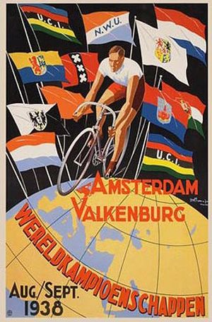
1938 UCI Road World Championships
Cycling championship held in Valkenburg, Netherlands
Distance: Approx. 1847 meters
Latitude and longitude: 50.84972222,5.83305556
The 1938 UCI Road World Championships was the eighteenth edition of the UCI Road World Championships. It took place in Valkenburg, Netherlands on 2 and 5 September 1938. Belgian Marcel Kint became the winner in the professional road race.

1948 UCI Road World Championships
Cycling championship held in Valkenburg, Netherlands
Distance: Approx. 1847 meters
Latitude and longitude: 50.84972222,5.83305556
The 1948 UCI Road World Championships was the 21st edition of the UCI Road World Championships It took place on Saturday 21 and Sunday 22 August 1948 in Valkenburg, Netherlands. For the first time, six riders per country were allowed to participate in the professional race. The Cauberg had to be climbed every lap.

Valkenburg railway station
Railway station in the Netherlands
Distance: Approx. 535 meters
Latitude and longitude: 50.86916667,5.83277778
Valkenburg railway station is located in Valkenburg aan de Geul, the Netherlands. The station was opened on 23 October 1853 and is located on the Maastricht–Aachen railway. The station building is the oldest in the Netherlands.
Prinses Juliana
Restaurant in Valkenburg aan de Geul, Netherlands
Distance: Approx. 292 meters
Latitude and longitude: 50.86841667,5.82834722
Prinses Juliana is a defunct restaurant located in Valkenburg aan de Geul in the Netherlands. It was a fine dining restaurant that was awarded one or two Michelin stars in the period 1958–2006. The last head chef was Andy Brauers.
De Lindenhorst
Restaurant in Valkenburg, Netherlands
Distance: Approx. 1007 meters
Latitude and longitude: 50.87171667,5.81621944
De Lindenhorst is a defunct restaurant in Valkenburg, Netherlands. It was a fine dining restaurant that was awarded one Michelin star in 1983 and retained that rating until 1993. Head chef in the time of the Michelin star was Ida Kleijnen.
Kruitmolen
Watermill in Valkenburg, Netherlands
Distance: Approx. 323 meters
Latitude and longitude: 50.8659,5.8226
The Kruitmolen (English: Powder mill, Limburgish: Polfermeule) is a watermill located on the Plenkertstraat 82 in Valkenburg aan de Geul, Netherlands. Build in 1820 along the Geul river, the watermill functioned as powder mill until 1851 and temporarily became a paper mill between 1875 and 1884. Since 1887 it is part of a brewery where it currently still forms a part of the electrical supply system.

De Valkenier
Amusement park in Valkenburg aan de Geul, Netherlands
Distance: Approx. 324 meters
Latitude and longitude: 50.868,5.824
De Valkenier (English: The falconer) was an amusement park in Valkenburg aan de Geul, Netherlands. The attractions focused mostly on families with children below the age of twelve. Founded by Jan Albert Otermans in 1934 under the name Ontspanningsoord Natuurbad Valkenburg (English: Recreational natural pool Valkenburg) it was the oldest amusement park in the Benelux countries.
Weather in this IP's area
overcast clouds
8 Celsius
8 Celsius
6 Celsius
9 Celsius
1029 hPa
99 %
1029 hPa
1020 hPa
10000 meters
0.63 m/s
0.69 m/s
152 degree
99 %
07:37:37
17:03:03


